| Previous :: Next Topic |
| Author |
Message |
Kim Brown
Member


Joined: 13 Jul 2009
Posts: 6899 | TRs | Pics
|
(moderator note: discussion split from another topic by request)
The Early Winters campground was a highway construction camp. There are some remains of an old water pump still there.
"..living on the east side of the Sierra world be ideal - except for harsher winters and the chance of apocalyptic fires burning the whole area."
Bosterson, NWHiker's marketing expert
"..living on the east side of the Sierra world be ideal - except for harsher winters and the chance of apocalyptic fires burning the whole area."
Bosterson, NWHiker's marketing expert
|
| Back to top |
  
|
|
fourteen410
Member

Joined: 23 May 2008
Posts: 2629 | TRs | Pics
|
| Kim Brown wrote: | | The Early Winters campground was a highway construction camp. |
Awesome to know! I love the historical tidbits on this site.
|
| Back to top |
|
|
Kim Brown
Member
Joined: 13 Jul 2009
Posts: 6899 | TRs | Pics
|
| fourteen410 wrote: | | Kim Brown wrote: | | The Early Winters campground was a highway construction camp. |
Awesome to know! I love the historical tidbits on this site. |
I'll pull up the article I wrote for WTA's magazine, which includes the citations on this information. I got a lot of info on the building of the highway from Jeff Adamson, who we all love, as he is the one who gives us the Highway 20 plowing reports each spring. He sent me some old newspaper & magazine articles.
"..living on the east side of the Sierra world be ideal - except for harsher winters and the chance of apocalyptic fires burning the whole area."
Bosterson, NWHiker's marketing expert
"..living on the east side of the Sierra world be ideal - except for harsher winters and the chance of apocalyptic fires burning the whole area."
Bosterson, NWHiker's marketing expert
|
| Back to top |
|
|
Kim Brown
Member
Joined: 13 Jul 2009
Posts: 6899 | TRs | Pics
|
"..living on the east side of the Sierra world be ideal - except for harsher winters and the chance of apocalyptic fires burning the whole area."
Bosterson, NWHiker's marketing expert
|
| Back to top |
|
|
Snowbrushy
Member
Joined: 23 Jul 2003
Posts: 6670 | TRs | Pics
Location: South Sound |
| Kim Brown wrote: | | OK, so I grabbed this link that Mr. Adamson sent me - 1972 collection of articles. |
Thank you Kim Brown for that report from 1895 about the state wagon road reconnaissance which followed the "old prospector trail." Apparently the original trail was mostly a backpacker trail with ladders. I can see why some minor would want to ditch (cache) heavy gear along the way to the mines.
Oh Pilot of the storm who leaves no trace Like thoughts inside a dream Heed the path that led me to that place Yellow desert stream.
Oh Pilot of the storm who leaves no trace Like thoughts inside a dream Heed the path that led me to that place Yellow desert stream.
|
| Back to top |
|
|
Malachai Constant
Member

Joined: 13 Jan 2002
Posts: 16092 | TRs | Pics
Location: Back Again Like A Bad Penny |
There was quite a rout there then before the dams. Bolts were driven into the canyon walls to support planks, kind of like the Camino del Roy in Spain. It must have been very cool. 
"You do not laugh when you look at the mountains, or when you look at the sea." Lafcadio Hearn
"You do not laugh when you look at the mountains, or when you look at the sea." Lafcadio Hearn
|
| Back to top |
|
|
puzzlr
Mid Fork Rocks

Joined: 13 Feb 2007
Posts: 7220 | TRs | Pics
Location: Stuck in the middle |
|
puzzlr
Mid Fork Rocks
|
 Mon Oct 12, 2015 10:19 pm |
|
|
Thanks for that link Kim. Great stuff. But who knows what other treasures are buried in the /NR/rdonlyres/ subbasement of the DOT website. Unfortunately, it doesn't allow a directory listing.
|
| Back to top |
|
|
Snowbrushy
Member
Joined: 23 Jul 2003
Posts: 6670 | TRs | Pics
Location: South Sound |
| puzzlr wrote: | | what other treasures are buried in the /NR/rdonlyres/ subbasement of the DOT website. |
Here is the public info about a state auto south Cascade pass that was actually given a state route number but never built. This was originally an alternate of the old Oregon wagon road (Oregon Trail.)
https://en.wikipedia.org/wiki/Washington_State_Route_168
Oh Pilot of the storm who leaves no trace Like thoughts inside a dream Heed the path that led me to that place Yellow desert stream.
Oh Pilot of the storm who leaves no trace Like thoughts inside a dream Heed the path that led me to that place Yellow desert stream.
|
| Back to top |
|
|
Snowbrushy
Member
Joined: 23 Jul 2003
Posts: 6670 | TRs | Pics
Location: South Sound |
| Kim Brown wrote: | | The Early Winters campground was a highway construction camp. There are some remains of an old water pump still there. |
Early Winters Ski Resort (Defunct) was a prospect taken into account for the decision to build the highway, along with the general economic development of the area - tourism. Gold and silver - the outfitters always follow closely and stick around after the gold rush and provide jobs. But they don't sell bacon.  https://en.wikipedia.org/wiki/Washington_State_Route_20
Oh Pilot of the storm who leaves no trace Like thoughts inside a dream Heed the path that led me to that place Yellow desert stream.
Oh Pilot of the storm who leaves no trace Like thoughts inside a dream Heed the path that led me to that place Yellow desert stream.
|
| Back to top |
|
|
Snowbrushy
Member
Joined: 23 Jul 2003
Posts: 6670 | TRs | Pics
Location: South Sound |
From the above Wiki article.
"History: What is known today as the North Cascades Highway was originally the corridor used by local Native American tribes as a trading route from Washington's Eastern Plateau country to the Pacific Coast for more than 8,000 years."
The above statement is debatable. The pass used was Cascade Pass. Many canoe were found at the top of Lake Chelan. The Indians didn't have planks and ladders to make a trail over the Skagit Pass. Cascade Pass was easier and involved water travel which was more agreeable. Furthermore, there wasn't much of a trade between west and east. It was more for social reasons of marriage, etc..
Oh Pilot of the storm who leaves no trace Like thoughts inside a dream Heed the path that led me to that place Yellow desert stream.
Oh Pilot of the storm who leaves no trace Like thoughts inside a dream Heed the path that led me to that place Yellow desert stream.
|
| Back to top |
|
|
Kim Brown
Member
Joined: 13 Jul 2009
Posts: 6899 | TRs | Pics
|
You're right about the social aspect of the route. I understand from a conversation I had with a Sauk Suiattle tribal member that the ancestral tribes that now comprise the Sauk Suiattle had relatives east of the crest. I would imagine there was some trade; if nothing else, trading gifts annually.
I enjoy stories about the origins of our modern roads. THe gent who posted about the hunters camp on an old road above highway 20 posted a fine story indeed. Stuff like that is cool.
"..living on the east side of the Sierra world be ideal - except for harsher winters and the chance of apocalyptic fires burning the whole area."
Bosterson, NWHiker's marketing expert
"..living on the east side of the Sierra world be ideal - except for harsher winters and the chance of apocalyptic fires burning the whole area."
Bosterson, NWHiker's marketing expert
|
| Back to top |
|
|
Snowbrushy
Member
Joined: 23 Jul 2003
Posts: 6670 | TRs | Pics
Location: South Sound |
| Kim Brown wrote: | | trading gifts |
Potlatch: https://en.wikipedia.org/wiki/Potlatch
I personally can't find any history to indicate that the highway 20 route was ever used in it's entirety as a trail or wagon road until the modern period. And that was about access to a "destination ski resort" to compete with resort development at Whistler in BC.
Oh Pilot of the storm who leaves no trace Like thoughts inside a dream Heed the path that led me to that place Yellow desert stream.
Oh Pilot of the storm who leaves no trace Like thoughts inside a dream Heed the path that led me to that place Yellow desert stream.
|
| Back to top |
|
|
Snowbrushy
Member
Joined: 23 Jul 2003
Posts: 6670 | TRs | Pics
Location: South Sound |
| Kim Brown wrote: | | I enjoy stories about the origins of our modern roads. |
This road is built on or along the oldest white trail through what used to be wilderness between Dupont, Wa. and the upper Cowlitz River. Between Fort Nisqually and the large Cowlitz Farm, and a water trail to Fort Vancouver, all of which were run by the British Hudsons Bay Company. American settlers would later use the trail and complain to the government about how muddy it could be.
http://americanroadmagazine.com/forum/index.php?showtopic=955
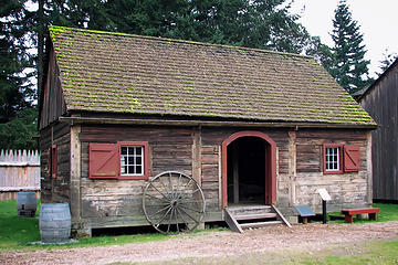 The Granary in Fort Nisqually.
Oh Pilot of the storm who leaves no trace Like thoughts inside a dream Heed the path that led me to that place Yellow desert stream.
Oh Pilot of the storm who leaves no trace Like thoughts inside a dream Heed the path that led me to that place Yellow desert stream.
|
| Back to top |
|
|
|
|


