| Previous :: Next Topic |
| Author |
Message |
mbravenboer
Member


Joined: 20 Oct 2013
Posts: 1422 | TRs | Pics
Location: Seattle |
I'm trying to quickly catch up on some of my post-poned summer hiking plans before winter takes over. One place I've enjoyed the trip reports from is Crater Mountain, Lake 6380 and Jerry Lakes. Notably, the report from GaliWalker ( https://www.nwhikers.net/forums/viewtopic.php?t=7970259 ) proved that it can be done in a day (at least by GaliWalker  ), and kyle d ( https://www.nwhikers.net/forums/viewtopic.php?t=7987156 ) demonstrated that the area has beautiful larch trees. Maybe I would get lucky with larches, a bit of snow, and a sunny day?
Me and my dog started hiking at 6am, the first 50 minutes with a headlamp (on the way out I learned that I didn't miss too much). The trail is a bit brushy in the beginning, but it soon gets better (so do not be discouraged) and even becomes extremely pleasant, covered in soft needles and with almost no rocks and roots. It took me about 2 hours to climb to the unmarked split to Crater Lake at 5200ft. There are two creek crossings in this section, both fairly large. The unmarked split is a small open area right before a small creek. Even without GPS it is hard to miss.
During the more mellow traverse to Crater Lake there were finally some views of the North Cascades peaks. Fog was hanging in the valley, which was quite pretty. There really isn't too much to see until close to the lake at 5800ft though, and with a trailhead at 1800ft, this hike is definitely more about the destination than the journey. ), and kyle d ( https://www.nwhikers.net/forums/viewtopic.php?t=7987156 ) demonstrated that the area has beautiful larch trees. Maybe I would get lucky with larches, a bit of snow, and a sunny day?
Me and my dog started hiking at 6am, the first 50 minutes with a headlamp (on the way out I learned that I didn't miss too much). The trail is a bit brushy in the beginning, but it soon gets better (so do not be discouraged) and even becomes extremely pleasant, covered in soft needles and with almost no rocks and roots. It took me about 2 hours to climb to the unmarked split to Crater Lake at 5200ft. There are two creek crossings in this section, both fairly large. The unmarked split is a small open area right before a small creek. Even without GPS it is hard to miss.
During the more mellow traverse to Crater Lake there were finally some views of the North Cascades peaks. Fog was hanging in the valley, which was quite pretty. There really isn't too much to see until close to the lake at 5800ft though, and with a trailhead at 1800ft, this hike is definitely more about the destination than the journey.
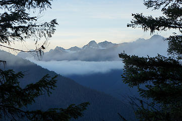 Foggy early morning in the North Cascades 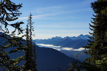 View south (Granite Creek drainage) 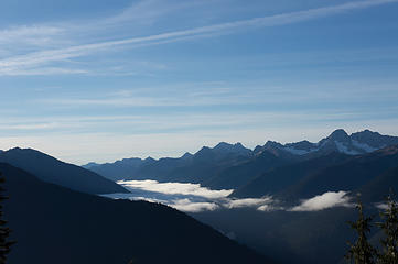 View south (Granite Creek drainage) 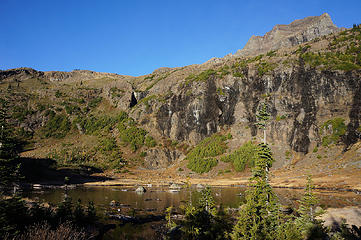 Crater Lake 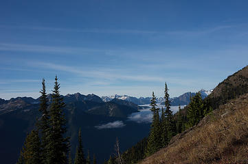 Early view west with fog hanging in the Panther and Thunder creek drainage. Later Snowfield Peak will become visible 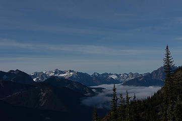 Early view of Eldorado in the distance 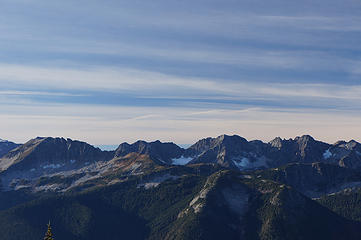 The modest Elija Ridge is easily overlooked in the sea of higher summits, but is quite beautiful 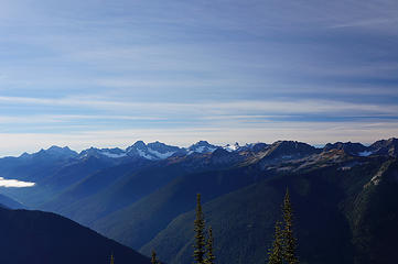 North Cascades (with some fresh snow on the higher peaks, like Mesahchie, Katsuk, and Kimtah in the middle) 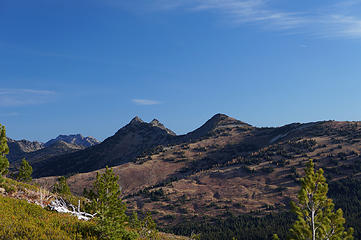 Devils Park with some larches 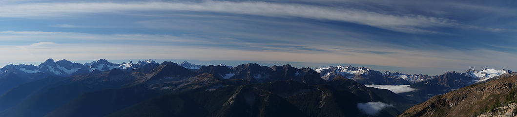 North Cascades Panorama 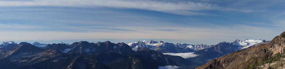 Panorama from Mt Logan to Snowfield Peak, with Ruby Mountain the foreground barely visible 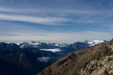 North Cascades peaks (Eldorado, Primus, Snowfield) 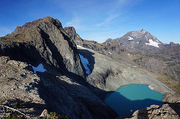 Lake 6380 and Jack Mountain in the background 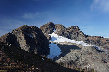 Crater Mountain with Jerry Glacier 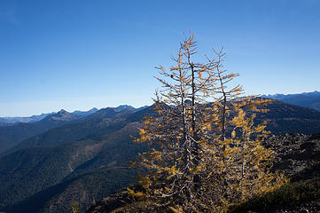 View north view with larches loosing their needles 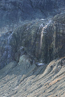 Frozen streams slowly melting in the sun 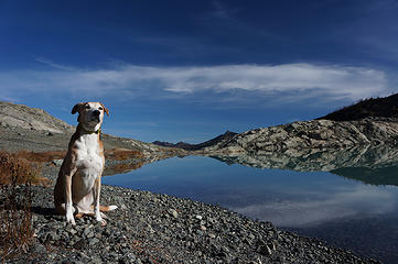 Liesl 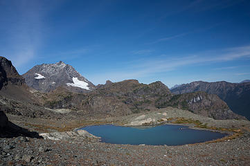 Tarn west of Lake 6380 with view of Jack Mountain 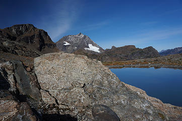 Beautiful rocks 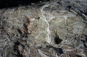 Beautiful rocks 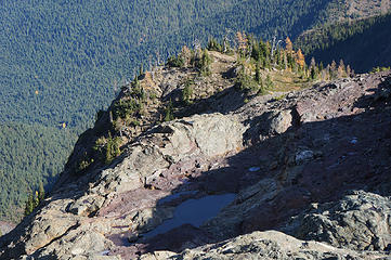 Interesting mixtures of rock types 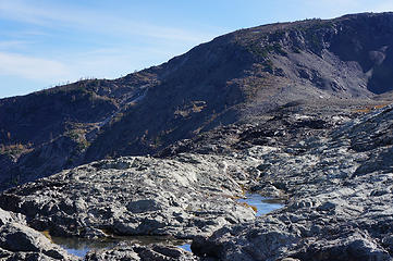 Looking back at the north-side of the Lookout No 2 ridge, which we traversed to get to the lake 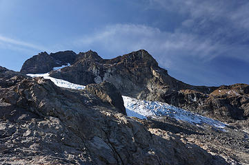 Jerry Glacier 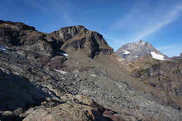 Below Jerry Glacier terminus 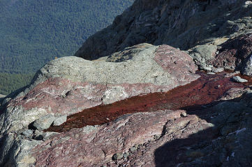 The area below the Jerry Glacier has many small red pools 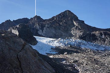 Jerry Glacier 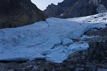 Jerry Glacier 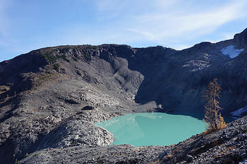 Lake 6380, a lone larch, and the ridge of lookout no 2 in the background 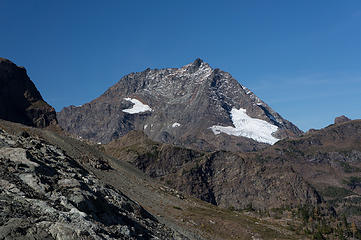 Jack Mountain 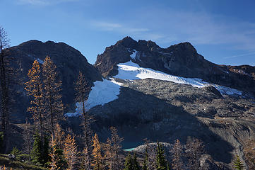 Larches, Lake 6380, Jerry Glacier and West+East summits of Crater Mountain 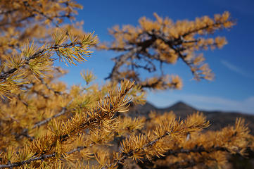 Larch 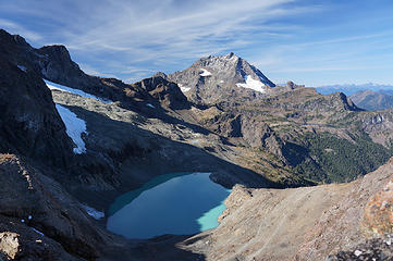 Lake 6380 and Jack Mountain in the background 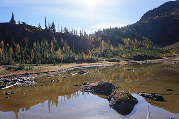 Crater Lake with a few larches 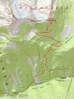 GPS track Crater Mountain Lookout No 2
|
| Back to top |
  
|
|
puzzlr
Mid Fork Rocks

Joined: 13 Feb 2007
Posts: 7220 | TRs | Pics
Location: Stuck in the middle |
|
puzzlr
Mid Fork Rocks
|
 Fri Oct 16, 2015 12:27 am |
|
|
Ever since going to the other Lookout as a side trip on the way to Jack I've wanted to go back and check out the lookout you went to. And I didn't realize the trail marked on the USGS topo was so far off, assuming your GPS is close the actual route.
|
| Back to top |
|
|
Bootpathguy
Member
Joined: 18 Jun 2015
Posts: 1790 | TRs | Pics
Location: United States |
 Nice report
Thanks for sharing
Nice report
Thanks for sharing
Experience is what'cha get, when you get what'cha don't want
Experience is what'cha get, when you get what'cha don't want
|
| Back to top |
|
|
iron
Member

Joined: 10 Aug 2008
Posts: 6392 | TRs | Pics
Location: southeast kootenays |
|
iron
Member
|
Fri Oct 16, 2015 8:10 pm |
|
|
awesome. this has been high on my larch trip hikes. there's a peak further north of interest as well.
|
| Back to top |
|
|
GaliWalker
Have camera will use

Joined: 10 Dec 2007
Posts: 4929 | TRs | Pics
Location: Pittsburgh |
|
GaliWalker
Have camera will use
|
Tue Oct 20, 2015 11:53 am |
|
|
Missed seeing this one, since I was on a hiking trip. Very cool! Very nice photos too (better than mine)!
| mbravenboer wrote: | | After checking the map and Google Earth I thought there is a slight detour that would perhaps at most be class 2, which turned out to be correct. I kept following the north ridge as far as possible, and then did a descending traverse of the north slope towards the lake. |
Yup, that's the route I took.
|
| Back to top |
|
|
mbravenboer
Member
Joined: 20 Oct 2013
Posts: 1422 | TRs | Pics
Location: Seattle |
Thanks GaliWalker! I think I still have a lot to learn before my photos approach your excellent reports, but I'll consider it an encouragement .
Thanks for sharing your route info.
|
| Back to top |
|
|
Brushbuffalo
Member

Joined: 17 Sep 2015
Posts: 1887 | TRs | Pics
Location: there earlier, here now, somewhere later... Bellingham in between |
Excellent TR for a beautiful area. Thanks.
Area trivia 1: while camping on top of main Crater in the 1970s, I dropped a cookpot off the top while scraping frozen snow from the summit cornice. Saw the fallen pot on the Jerry Glacier far below. Went down and around to get it but also found a double-bitted axe that must have been tossed off the top when the lookout was destroyed. Seems odd to have had such a tool 1500' above trees.. The axe resides on my woodshed to this day (I considered it litter rather than an artifact, since it was quite out of place).  Trivia 2: we talked with a couple loaded down with rock-climbing gear including large angle pitons ( called "bongs" back in the day)to climb what, I don't know...who spoke of a grizzly sighting near Jerry Lakes.... Trivia 2: we talked with a couple loaded down with rock-climbing gear including large angle pitons ( called "bongs" back in the day)to climb what, I don't know...who spoke of a grizzly sighting near Jerry Lakes....  Identity of bear never verified SFAIK., but it is wild enough back there to be grizz habitat. Identity of bear never verified SFAIK., but it is wild enough back there to be grizz habitat.
Passing rocks and trees like they were standing still
Passing rocks and trees like they were standing still
|
| Back to top |
|
|
Distel32
Member
Joined: 03 Jun 2014
Posts: 961 | TRs | Pics
Location: Edmonds, WA |
|
Distel32
Member
|
Fri Oct 23, 2015 2:15 pm |
|
|
|
| Back to top |
|
|
|
|
You cannot post new topics in this forum
You cannot reply to topics in this forum
You cannot edit your posts in this forum
You cannot delete your posts in this forum
You cannot vote in polls in this forum
|
Disclosure: As an Amazon Associate NWHikers.net earns from qualifying purchases when you use our link(s). |


