| Previous :: Next Topic |
| Author |
Message |
Hulksmash
Cleaning up.


Joined: 20 Apr 2008
Posts: 7113 | TRs | Pics
Location: Arlington |
|
Hulksmash
Cleaning up.
|
 Thu Apr 07, 2016 8:50 am |
|
|
So realize that what is a recreational trail today did not start out that way. Yes there are some exceptions, but the vast majority were built to some reason other than hiking. They are left over from the days before the automobile was the prevalent form of transportation...the railroad did not go everywhere.
If there was something that needed to be transported pack stock was often the choice method. Trail were built to accomdate pack strings. The effort then (and still is now) to build was a ludicrous investment of time and labor. The were not haphazardly located.
Obviously the trails were quickly adopted for recreation. Vintage recreation books are a good source of information. But also hunting/foraging books. Mining history, logging history, fire history.
One more thing i forgot the national archives is a good resource.
Here's a Linky
"Bears couldn't care less about us....we smell bad and don't taste too good. Bugs on the other hand see us as vending machines." - WetDog
Albuterol! it's the 11th essential
"Bears couldn't care less about us....we smell bad and don't taste too good. Bugs on the other hand see us as vending machines." - WetDog
Albuterol! it's the 11th essential
|
| Back to top |
  
|
|
RodF
Member

Joined: 01 Sep 2007
Posts: 2593 | TRs | Pics
Location: Sequim WA |
|
RodF
Member
|
Thu Apr 07, 2016 12:10 pm |
|
|
Every historical (pre-1960) USFS, NPS or commercial guide map I've seen contains errors, including misplaced and missing sites and trails. (Compare the various trail maps cited in this list of abandoned trails in the Olympics, for example.)
The USGS historical maps are the most accurate maps available. However, they depict only "built trails", not way trails and routes. And the first USGS topo maps of much of the interior and southern Olympics weren't issued until 1956 (the last area in the contiguous 48 states in which USGS completed 15-minute topo mapping).
The original (1905-1928) USFS trail system was funded by Congress explicitly for fire protection purposes, so most are at low elevation in river valleys. The first exception (a trail built purely for recreational purposes) in the Pacific Northwest is Eagle Creek Trail, begun in 1916. In the 1920s, USFS began building alpine trails specifically for recreational purposes. Flagging and construction of the Oregon Skyline Trail (today's Pacific Crest Trail) began in 1920 and was essentially complete by 1936.
"of all the paths you take in life, make sure a few of them are dirt" - John Muir
"the wild is not the opposite of cultivated. It is the opposite of the captivated - Vandana Shiva
"of all the paths you take in life, make sure a few of them are dirt" - John Muir
"the wild is not the opposite of cultivated. It is the opposite of the captivated - Vandana Shiva
|
| Back to top |
|
|
Schroder
Member

Joined: 26 Oct 2007
Posts: 6722 | TRs | Pics
Location: on the beach |
|
Schroder
Member
|
Fri Apr 08, 2016 9:58 am |
|
|
| Bdcast34 wrote: | | nyone have any new information on obtaining old trail maps/guide books? |
Caltopo has historic map layers. Just go to the drop-down menu in the upper right corner and select the layer you want
|
| Back to top |
|
|
puzzlr
Mid Fork Rocks

Joined: 13 Feb 2007
Posts: 7220 | TRs | Pics
Location: Stuck in the middle |
|
puzzlr
Mid Fork Rocks
|
Fri Apr 08, 2016 12:49 pm |
|
|
One of my fears with the very useful and frequently updated online maps is that the historical record left by old maps will not be available in the future. In 2050 will you be able to pull up a Google street map circa 2015?
I've been looking for old maps covering the Middle Fork Snoqualmie area for ten years and have hundreds covering various areas and at various scales. Maps show up in lots of places if you pay attention. The USGS historical map archive is great for the topos, and the caltopo link is the easiest way to browse the main versions. The Mountaineers have a good collection of maps, but currently they are not publicly accessible. For King County there are some interesting maps in the Road Services Map Vault, other counties may have similar resources. The downtown Seattle Public Library has most of the old Kroll maps in the special collections area on the top floor - but these focused on property ownership and the accuracy of the trail lines in outlying areas is terrible. Old guidebooks are great sources for trail history and I've found AbeBooks to be the best source for the lowest cost.
I have found that Forest Service Recreation Maps, the kind you would buy at Ranger Stations, are some of the most useful for old trails, but also some of the hardest to find. No-one seems to keep the old ones and the USFS doesn't archive them online like the USGS does. I've been able to collect this set of old maps and have the content stacked in Photoshop layers for easy comparison of changes. Way fun!
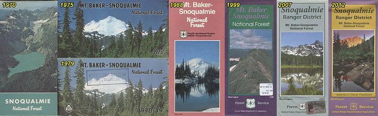 My collection of USFS recreation maps for the Snoqualmie, then Mount Baker Snoqualmie region
|
| Back to top |
|
|
BdCast
Member

Joined: 13 May 2011
Posts: 238 | TRs | Pics
Location: Washington |
|
BdCast
Member
|
Fri Apr 08, 2016 1:06 pm |
|
|
| Schroder wrote: | | Caltopo has historic map layers |
That's an awesome resource. Much easier to browse than the USGS site.
|
| Back to top |
|
|
BdCast
Member
Joined: 13 May 2011
Posts: 238 | TRs | Pics
Location: Washington |
|
BdCast
Member
|
Fri Apr 08, 2016 1:07 pm |
|
|
| puzzlr wrote: | | I have found that Forest Service Recreation Maps, the kind you would buy at Ranger Stations, are some of the most useful for old trails, but also some of the hardest to find. |
Good to know! I wouldn't expect that an agency wouldnt be keeping inventory of all maps created. I'll keep an eye out for any vintage FSR maps that might pop up. I bet at the Packwood flea market you might be able to find some gems. I'll have to take a look this summer.
|
| Back to top |
|
|
mb
Member
Joined: 11 Aug 2002
Posts: 507 | TRs | Pics
|
|
mb
Member
|
Fri Apr 08, 2016 10:47 pm |
|
|
On digital ephemera, See also:
http://www.rumseywrites.com/
And places like the internet archive, where she's next speaking. Haven't read the book but the topic is interestg.
(See also map collector David Rumsey.)
|
| Back to top |
|
|
contour5
Member

Joined: 16 Jul 2003
Posts: 2963 | TRs | Pics
|
|
contour5
Member
|
Fri Apr 08, 2016 11:45 pm |
|
|
| Quote: | | Anyone have any new information on obtaining old trail maps/guide books? |
I've built a small library of old hiking books from my local Value Village. It's kind of hit and miss- usually there's not much, but a few times a year, on average, a huge pile of old guidebooks will suddenly appear. It always gives me a slight twinge of sadness, when I reflect that some unknown hiker has hiked their last hike, or maybe worse, but the books are always $2.99 or less, often well thumbed and sometimes with cryptic markings or useful notes written in the margins.
There's another local used book shop which I shall keep a secret, even though the prices are a rip off and the owner is a snob- she somehow manages to latch onto the most delightfully rare and obscure titles and sometimes has really cool, long out of print maps.
Magus Books in the U District gets a pretty steady stream of interesting old guidebooks...
|
| Back to top |
|
|
BdCast
Member
Joined: 13 May 2011
Posts: 238 | TRs | Pics
Location: Washington |
|
BdCast
Member
|
Wed Nov 14, 2018 9:22 am |
|
|
I love this topic of old and forgotten trails/collectible maps.
I used the search function and stumbled on this thread, and then realize I myself resurrected the discussion a couple years back. Figured I should resurrect it again! This time, I find myself with a slight collection of old vintage maps, and a desire to find more. So, if anyone know of any good local (Tacoma) used book stores that might have some historical guide books, or historical maps, Id love to know.
I still have yet to check out the physical UW collection in the library, but one of these days I will get myself up there to have a look.
|
| Back to top |
|
|
RodF
Member
Joined: 01 Sep 2007
Posts: 2593 | TRs | Pics
Location: Sequim WA |
|
RodF
Member
|
Wed Nov 14, 2018 2:20 pm |
|
|
| BdCast wrote: | | So, if anyone know of any good local (Tacoma) used book stores that might have some historical guide books, or historical maps, Id love to know. |
Tacoma Public Library is a Federal depository library, and its Northwest Room would be worth checking out, too.
Washington State Library in Tumwater has an even more extensive collection.
Both are happy to allow you to bring your laptop and scanner.
"of all the paths you take in life, make sure a few of them are dirt" - John Muir
"the wild is not the opposite of cultivated. It is the opposite of the captivated - Vandana Shiva
"of all the paths you take in life, make sure a few of them are dirt" - John Muir
"the wild is not the opposite of cultivated. It is the opposite of the captivated - Vandana Shiva
|
| Back to top |
|
|
Riverside Laker
Member

Joined: 12 Jan 2004
Posts: 2818 | TRs | Pics
|
|
| Back to top |
|
|
DIYSteve
seeking hygge

Joined: 06 Mar 2007
Posts: 12655 | TRs | Pics
Location: here now |
|
DIYSteve
seeking hygge
|
Wed Nov 14, 2018 3:33 pm |
|
|
| Schroder wrote: | | Caltopo has historic map layers. Just go to the drop-down menu in the upper right corner and select the layer you want |
FTR, this is a 2-1/2 year old post. Caltopo has stripped out at least one old map database from its menu. A few years ago, an old map, then available on the Caltopo menu, showed the old mining road that climbed from Esmeralda Basin to closely below Ingalls Pass (sometimes depicted as "Stuart Pass" on old maps). As I recall, the road appeared as a county road. AFAICT, that map database is no longer on the Caltopo menu. (We sometimes skin up that old road bed when spring ski touring.)
|
| Back to top |
|
|
BdCast
Member
Joined: 13 May 2011
Posts: 238 | TRs | Pics
Location: Washington |
|
BdCast
Member
|
Wed Nov 14, 2018 5:30 pm |
|
|
Thanks Riverside, yup Im using caltopo as a resource often. Resurfaced this old thread to see anyone had any more info to add, or if the community wanted to discuss old and forgotten trails again.
I encourage you guys to read the earlier posts here about the old Chenius creek trail that was being maintained by forum members. Good example of old trails that used to lead to incredible places(Independence Ridge - Windy Gap).
|
| Back to top |
|
|
BdCast
Member
Joined: 13 May 2011
Posts: 238 | TRs | Pics
Location: Washington |
|
BdCast
Member
|
Wed Nov 14, 2018 5:36 pm |
|
|
I guess one new topic of discussion, that I would be interested to see if anyone had information on, is the plethora of shelters and cabins that are marked on the historical USFS maps around Mount Rainier NP. If you looks specifically in the area north of the Carbon Glacier terminus, and east towards Skyscraper Islamabad you can see what Im talking able. Theres also a lot of cabins in the hills about the American river easy of Chinook. Im curious how many of these are still there or if theyve all been destroyed.
|
| Back to top |
|
|
Kim Brown
Member
Joined: 13 Jul 2009
Posts: 6899 | TRs | Pics
|
| BdCast wrote: | | Skyscraper Islamabad |
Pretty much the best auto-correct I have ever seen.
"..living on the east side of the Sierra world be ideal - except for harsher winters and the chance of apocalyptic fires burning the whole area."
Bosterson, NWHiker's marketing expert
"..living on the east side of the Sierra world be ideal - except for harsher winters and the chance of apocalyptic fires burning the whole area."
Bosterson, NWHiker's marketing expert
|
| Back to top |
|
|
|
|


