| Previous :: Next Topic |
| Author |
Message |
Eric Willhite
Member


Joined: 26 Aug 2010
Posts: 204 | TRs | Pics
|
|
| Back to top |
  
|
|
RodF
Member

Joined: 01 Sep 2007
Posts: 2593 | TRs | Pics
Location: Sequim WA |
|
RodF
Member
|
 Wed Jan 18, 2017 2:32 pm |
|
|
Bald AWS site (Kayosta Beach) - the location you identify as "Shelter shown here on 1950s and 60s maps" is confirmed by Frederick Leissler in his guidebook "Roads and Trails of Olympic National Park" (UW Press, 1957) p. 52 "An abandoned Coast Guard cabin is located at the tip of this point." which he calls Point No. 3 on his map 8. He also notes "old Coast Guard trail... is steep and rough" over that point.
The Park's 1976 Backcountry Management Plan lists Norwegian Memorial shelter, which I assume is the same structure? On Park shelter lists, it's location is given as "7 miles north of Mora Road" and is described as being in "good" condition and "usable", and report its roof was repaired in 1980. Through the 1970s and 1980s, Park shelter plans vacillate, listing it alternatively for retention or removal, with no record it was ever removed. So its logs may still be there.
"of all the paths you take in life, make sure a few of them are dirt" - John Muir
"the wild is not the opposite of cultivated. It is the opposite of the captivated - Vandana Shiva
"of all the paths you take in life, make sure a few of them are dirt" - John Muir
"the wild is not the opposite of cultivated. It is the opposite of the captivated - Vandana Shiva
|
| Back to top |
|
|
tinman
Member

Joined: 08 Oct 2004
Posts: 355 | TRs | Pics
Location: Where it rains, WA |
|
tinman
Member
|
Wed Jan 18, 2017 4:44 pm |
|
|
Eric and Rod, the Coast Guard Cabin and the Norwegian Shelter were 2 different structures. The Coastie Cabin was located on a point (remnants still there) about 1/2 mile south of the Starbuck Mine site. The trail over the top of the point to the cabin site is very steep on the north side as Leissler said.
The Norwegian shelter was located on the south side of the unnamed creek south of the Norwegian Monument. It was burned down in the late 80's or maybe early 90's. It was a small shelter crudely constructed of beach logs but was very serviceable when burnt.
Now to complicate things more, I believe the original AWS lookout was built on the point just to the north of Cedar Creek. See attached pictures, taken during the war. When I first visited there in the early 80's there was still a cable handrail and steps cut out of the rock leading to where the cabin had been. It was obvious that the rock had collapsed to the beach where the cabin had been. That point has continued to erode over the last 30+ years I have seen it. I can surmise that the cabin was then moved to the sight south of Starbuck Creek on a more stable point.
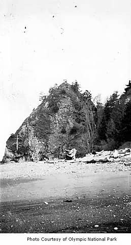 Cedar Crk Lookout 2 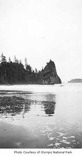 Cedar Crk Lookout 1
Wherever you go, there you are.......
Wherever you go, there you are.......
|
| Back to top |
|
|
RodF
Member
Joined: 01 Sep 2007
Posts: 2593 | TRs | Pics
Location: Sequim WA |
|
RodF
Member
|
Wed Jan 18, 2017 8:00 pm |
|
|
Tinman, thanks for sharing the photos and your excellent clarification on the cabin vs. the shelter! (The needless destruction of so many perfectly serviceable shelters is  a sad chapter in the Park's history.)
Eric, mailed you scans of Leissler's text and map, showing the cabin in its original location in 1957. a sad chapter in the Park's history.)
Eric, mailed you scans of Leissler's text and map, showing the cabin in its original location in 1957.
"of all the paths you take in life, make sure a few of them are dirt" - John Muir
"the wild is not the opposite of cultivated. It is the opposite of the captivated - Vandana Shiva
"of all the paths you take in life, make sure a few of them are dirt" - John Muir
"the wild is not the opposite of cultivated. It is the opposite of the captivated - Vandana Shiva
|
| Back to top |
|
|
tinman
Member
Joined: 08 Oct 2004
Posts: 355 | TRs | Pics
Location: Where it rains, WA |
|
tinman
Member
|
Wed Jan 18, 2017 8:47 pm |
|
|
Wherever you go, there you are.......
|
| Back to top |
|
|
yorknl
Member
Joined: 04 Aug 2008
Posts: 136 | TRs | Pics
|
|
yorknl
Member
|
Wed Jan 18, 2017 9:10 pm |
|
|
Eric, I'm a little confused about the location of the South Ozette site. Both of the AWS maps appear to place it somewhere on Boot Bay, not the spot on the '56 USGS map with the shelter notation. The comment on your page about the cabin being on a mountain stream would be consistent with a spot on Boot Bay near Quinn Creek's outlet. On the other hand, it makes little sense to put an observation cabin in a little geologic pocket like that which presumably has at least a slightly impaired view toward the south end of the lake. It's not like fresh water would have been difficult to find at the other site, either, what with the lake being omnipresent - there'd be no reason to pick a creekside location over any other candidate.
I've never laid eyes on that area of Lake Ozette and have no idea what the reality of the situation was; rather I'm curious if anyone else out there has any evidence one way or the other. Cool findings, regardless!
|
| Back to top |
|
|
Deereguy
Member
Joined: 22 Sep 2010
Posts: 65 | TRs | Pics
|
|
Deereguy
Member
|
Wed Jan 18, 2017 11:50 pm |
|
|
Around 1956, us kids were messing around Yellow Banks, up on the hill. We found a cabin apparently used for sighting military purposes. As I recall, the cabin was perfectly fitted with stuff. At that time, the cabin was ready to fall over the hill. I went back years later to see if I could find any remnants, which I couldn't. It's funny, but I can still see (in my mind) the cabin and porch overlook. deereguy
|
| Back to top |
|
|
RodF
Member
Joined: 01 Sep 2007
Posts: 2593 | TRs | Pics
Location: Sequim WA |
|
RodF
Member
|
Thu Jan 19, 2017 1:41 am |
|
|
| Eric Willhite wrote: | | But even the given STR produced a location that wasn't right on the lake. I don't know what map they used in the 1940's to get the STR but the given STR looks wrong. |
Checking pre-war USGS and Park maps, the TRS lines are slightly shifted, but the difference is both too small (less than 1/16 mile) and is in the wrong direction to have put the AWS coordinates on the lakeshore.
"of all the paths you take in life, make sure a few of them are dirt" - John Muir
"the wild is not the opposite of cultivated. It is the opposite of the captivated - Vandana Shiva
"of all the paths you take in life, make sure a few of them are dirt" - John Muir
"the wild is not the opposite of cultivated. It is the opposite of the captivated - Vandana Shiva
|
| Back to top |
|
|
yorknl
Member
Joined: 04 Aug 2008
Posts: 136 | TRs | Pics
|
|
yorknl
Member
|
Thu Jan 19, 2017 9:37 pm |
|
|
Unless somebody with first-hand knowledge pops up, we may never know the truth of this very, very important mystery concerning South Ozette. In the meantime the point north of Boot Bay feels - for all it's worth - a better fit to the known data. Eric, like others I think it's supremely cool that you poke into all these old sites with such vigor!
|
| Back to top |
|
|
|
|


