| Previous :: Next Topic |
| Author |
Message |
Matt
Tea, Earl Grey, Hot


Joined: 30 Jan 2007
Posts: 4307 | TRs | Pics
Location: Shoreline |
|
Matt
Tea, Earl Grey, Hot
|
 Sun Feb 05, 2017 11:34 am |
|
|
Date: 1/28/17
Destination: Lookout Mountain 5699 (USGS Big Devil)
Party: Matt, Dicey, Snowdog, BarbE, Steph Abegg
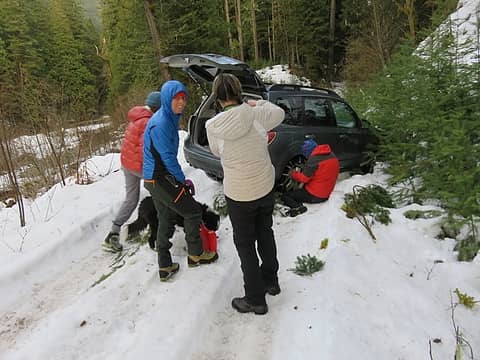
Our original goal was Oakes & Acorn peaks. The starting point on the Bacon Creek Road is at only 700 feet, so I thought we'd be able to drive that far. Nope. The road was snow covered almost from the start, but had existing tire ruts so we tried driving up it. About a mile in, I steered wrong, veered out of the ruts, and got stuck. After half an hour of digging and pushing, we got the car back straight on the road, but decided not to try driving the additional 1.5 miles for Oakes.
So instead we went to Lookout Mtn. The Cascade River Road was plowed to the Forest Service boundary, and then had compact snow and ice on the road, but it was low enough that we made it to the trailhead.
 Stuck on the Bacon Creek Road 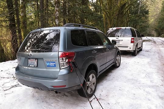 Lookout Mtn trailhead 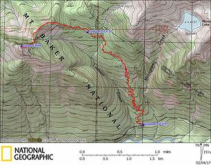 Lookout Mtn GPS track 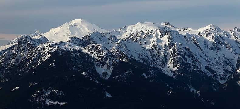 5 labels Looking northwest to Baker & Bacon 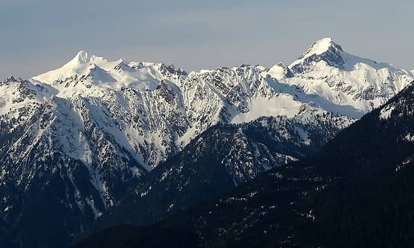 Shuksan & Blum 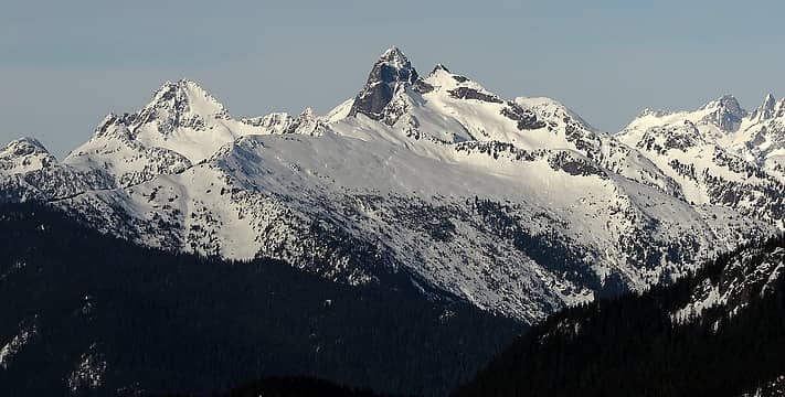 Despair & Triumph 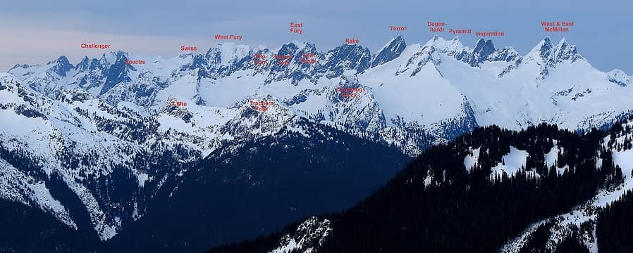 The whole Picket Range, also showing why Trappers Peak is such a fine viewpoint. 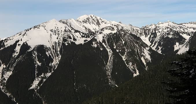 Big Devil & Six Hellions 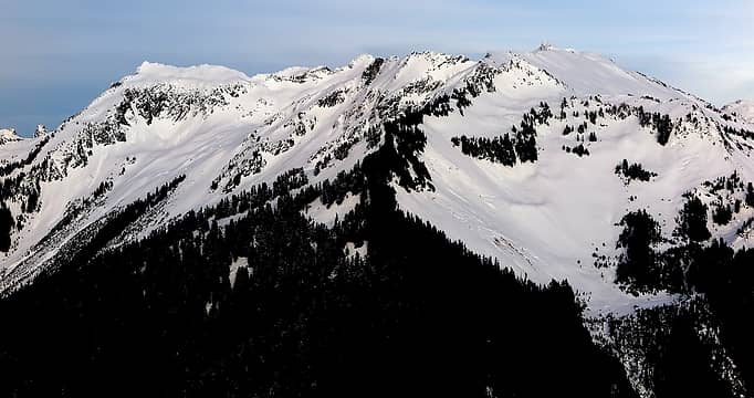 Looking up Teebone Ridge to Little Devil, and then Baksit (Middle Devil) on the left 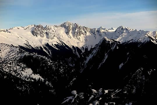 Eldorado standing above Marble Creek Cirque 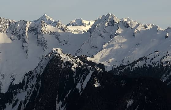 Ex Spire, with Forbidden, Buckner, a corner of Boston, Triad, and Sahale 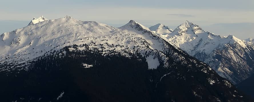 Hidden Lake Peak & Lookout, with Johannesburg peeking around its left shoulder, and Spider & Formidable on the right 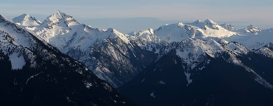 Core of the Ptargmigan Traverse Spider & Formidable, Sentinel & Old Guard 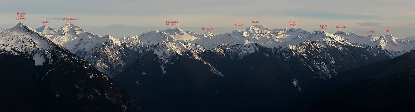 Looking further down the Ptargmigan Traverse to Sentinel & Old Guard, Sinister & Dome, Spire Point, Sonny Boy and the Bruseth peaks 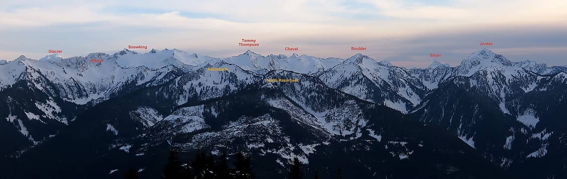 The peaks southward: Razorback covers most of the foreground. Main horizon peaks include Snowking, Tommy Thompson, Boulder & Jordan. Peeking up in the background are Glacier at left, Chaval in center, and Sloan at left. 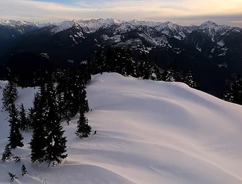 A hint of color on the snow below the lookout 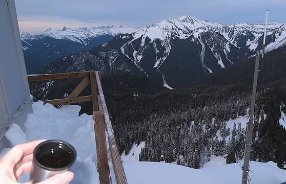 Tea on the lookout, with Pickets and Big Devil 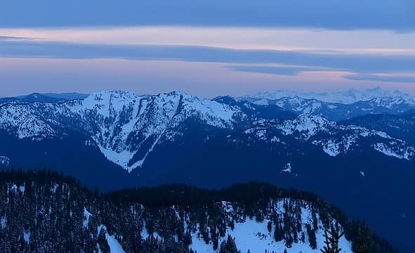 Faint color in the west, above Sauk, Bald, and the Sisters Range 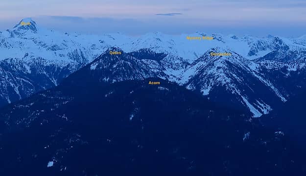 Twilight view of the peaks we'd originally intended to climb today
As beacons mountains burned at evening. J.R.R. Tolkien
As beacons mountains burned at evening. J.R.R. Tolkien
|
| Back to top |
  
|
|
KarlK
Member

Joined: 18 Jun 2009
Posts: 584 | TRs | Pics
|
|
KarlK
Member
|
Sun Feb 05, 2017 1:06 pm |
|
|
Your photos are terrific (as always)...
|
| Back to top |
|
|
mbravenboer
Member
Joined: 20 Oct 2013
Posts: 1422 | TRs | Pics
Location: Seattle |
 Thanks for road conditions update in the area and the Suiattle River Road. I've been curious how much snow & ice there is, and it sounds like it's not trivial to drive.
|
| Back to top |
|
|
fourteen410
Member

Joined: 23 May 2008
Posts: 2628 | TRs | Pics
|
|
| Back to top |
|
|
Stefan
Member

Joined: 17 Dec 2001
Posts: 5091 | TRs | Pics
|
|
Stefan
Member
|
Mon Feb 06, 2017 4:30 pm |
|
|
Love the smile from Dicey while Matt sits on the ground! 
|
| Back to top |
|
|
Justus S.
Member
Joined: 17 Nov 2004
Posts: 1298 | TRs | Pics
Location: WA |
Great pics Matt looks pleasant.
|
| Back to top |
|
|
Nancyann
Member
Joined: 28 Jul 2013
Posts: 2318 | TRs | Pics
Location: Sultan Basin |
|
Nancyann
Member
|
Tue Feb 07, 2017 12:18 pm |
|
|
Thanks for the labels on the pictures, Matt. Fantastic!
|
| Back to top |
|
|
iron
Member

Joined: 10 Aug 2008
Posts: 6392 | TRs | Pics
Location: southeast kootenays |
|
iron
Member
|
Tue Feb 07, 2017 4:43 pm |
|
|
your pic of mystery ridge with oakes in the foreground gave me pause --- pause that it was connected somewhat reasonably. alas, i see there is 'some' amount of work to connect the two, but i did have the thought that a nice little loop, even a backpack, could be made from oakes to damnation to the thornton area. stash a bike up at thornton lakes TH and you're good to go!
|
| Back to top |
|
|
contour5
Member

Joined: 16 Jul 2003
Posts: 2963 | TRs | Pics
|
|
contour5
Member
|
Tue Feb 07, 2017 11:43 pm |
|
|
Some fine views from the lookout. Thanks for the labels on the photos; they're always helpful for getting a better grasp of the landscape.
Hmmm, Mystery Ridge...
|
| Back to top |
|
|
Matt
Tea, Earl Grey, Hot
Joined: 30 Jan 2007
Posts: 4307 | TRs | Pics
Location: Shoreline |
|
Matt
Tea, Earl Grey, Hot
|
Wed Feb 08, 2017 12:27 am |
|
|
| iron wrote: | | your pic of mystery ridge with oakes in the foreground gave me pause --- pause that it was connected somewhat reasonably. alas, i see there is 'some' amount of work to connect the two, |
Unfortunately the entire Bacon Creek valley lines in between.
As beacons mountains burned at evening. J.R.R. Tolkien
As beacons mountains burned at evening. J.R.R. Tolkien
|
| Back to top |
|
|
Matt
Tea, Earl Grey, Hot
Joined: 30 Jan 2007
Posts: 4307 | TRs | Pics
Location: Shoreline |
|
Matt
Tea, Earl Grey, Hot
|
Wed Feb 08, 2017 12:27 am |
|
|
I added labels to a couple more of the photos.
As beacons mountains burned at evening. J.R.R. Tolkien
As beacons mountains burned at evening. J.R.R. Tolkien
|
| Back to top |
|
|
D. Inscho
Not bored yet...

Joined: 28 Feb 2010
Posts: 973 | TRs | Pics
Location: Bellingham,WA |
|
D. Inscho
Not bored yet...
|
Thu Feb 09, 2017 8:20 am |
|
|
A fine effort Matt, considerable even without snow. Great index of surrounding peaks too.
Any evidence of roof leaks on the inside of the structure? The flat roof has proven quite a challenge to pin down the compromised area. Any loose shutters? Thanks for any info.
http://david-inscho.smugmug.com/
The key to a successful trip is to do the planning during work hours. -- John Muir
My most memorable hikes can be classified as 'Shortcuts that Backfired'. --Ed Abbey
http://david-inscho.smugmug.com/
The key to a successful trip is to do the planning during work hours. -- John Muir
My most memorable hikes can be classified as 'Shortcuts that Backfired'. --Ed Abbey
|
| Back to top |
|
|
Distel32
Member
Joined: 03 Jun 2014
Posts: 961 | TRs | Pics
Location: Edmonds, WA |
|
Distel32
Member
|
Sat Feb 11, 2017 10:30 am |
|
|
|
| Back to top |
|
|
Matt
Tea, Earl Grey, Hot
Joined: 30 Jan 2007
Posts: 4307 | TRs | Pics
Location: Shoreline |
|
Matt
Tea, Earl Grey, Hot
|
Sat Feb 11, 2017 10:55 am |
|
|
| D. Inscho wrote: | | Any evidence of roof leaks on the inside of the structure? The flat roof has proven quite a challenge to pin down the compromised area. Any loose shutters? Thanks for any info |
I didn't see any evidence of leaks. It was too cold to leak during the period I was there, but there was no frozen water or drips anywhere inside. I didn't notice any loose shutters, but I also didn't look closely at them. There were several windows that don't have shutters at all. Is that normal?
As beacons mountains burned at evening. J.R.R. Tolkien
As beacons mountains burned at evening. J.R.R. Tolkien
|
| Back to top |
|
|
D. Inscho
Not bored yet...
Joined: 28 Feb 2010
Posts: 973 | TRs | Pics
Location: Bellingham,WA |
|
D. Inscho
Not bored yet...
|
Sun Feb 12, 2017 11:02 am |
|
|
Thanks for the news Matt. There are are a few shutters missing so some uncovered windows are normal.
http://david-inscho.smugmug.com/
The key to a successful trip is to do the planning during work hours. -- John Muir
My most memorable hikes can be classified as 'Shortcuts that Backfired'. --Ed Abbey
http://david-inscho.smugmug.com/
The key to a successful trip is to do the planning during work hours. -- John Muir
My most memorable hikes can be classified as 'Shortcuts that Backfired'. --Ed Abbey
|
| Back to top |
|
|
|
|
You cannot post new topics in this forum
You cannot reply to topics in this forum
You cannot edit your posts in this forum
You cannot delete your posts in this forum
You cannot vote in polls in this forum
|
Disclosure: As an Amazon Associate NWHikers.net earns from qualifying purchases when you use our link(s). |


.JPG#1600x1200)


