| Previous :: Next Topic |
| Author |
Message |
Matt
Tea, Earl Grey, Hot


Joined: 30 Jan 2007
Posts: 4307 | TRs | Pics
Location: Shoreline |
|
Matt
Tea, Earl Grey, Hot
|
 Sat Feb 11, 2017 11:08 am |
|
|
Anyone have any current info on how far the North Fork Skykomish Road is driveable going north from Index?
As beacons mountains burned at evening. J.R.R. Tolkien
As beacons mountains burned at evening. J.R.R. Tolkien
|
| Back to top |
  
|
|
RichP
Member

Joined: 13 Jul 2006
Posts: 5634 | TRs | Pics
Location: here |
|
RichP
Member
|
Sat Feb 11, 2017 1:42 pm |
|
|
Matt,
Nanyann sent me this detailed pm on the road when I had the same question thinking of a trip to Mineral Butte a couple of weeks ago. I still don't have a clear picture of how far up the road one can drive from Index but a follow up message stated that it was a 2.5 mile walk to Howard Ck from where they parked.
I decided to postpone the trip until the days get a bit longer.
| Quote: | | Nancyann wrote: | Hi Rich, that darn bypass trail is a real mess. The state has marked out their proposed route and there are several different unofficial trails put in by locals who have properties on the other side. There are different colored markers and tree bands all over the place. This is the third time I have been through there, and we went a different way after the first quarter mile due to blowdowns, basically following boot prints in the snow. I didn't take any pics for the first 1/4 mile because I was too busy navigating through the mess. We actually ended up crossing to the other side of the N. Fork Sky, and then re crossing it to get to the other end of the washed out road. This will not be possible as soon as the river level goes up.
We crossed after dropping down off the hillside, right at this big snow-covered culvert.
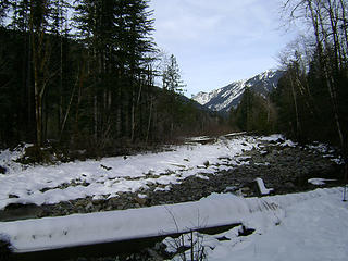 Index-Galena washout trail 1/28/17 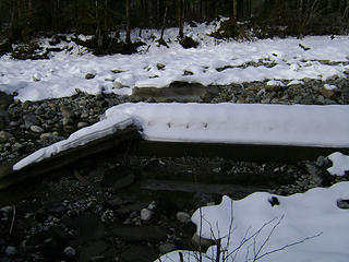 Index-Galena washout trail 1/28/17 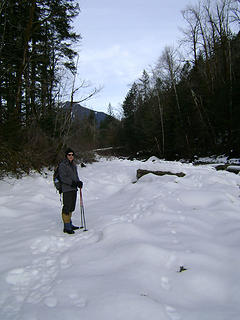 Index-Galena washout trail 1/28/17 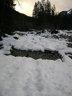 Index-Galena washout trail 1/28/17 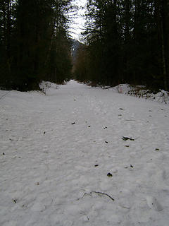 Index-Galena Road past the washout 1/28/17 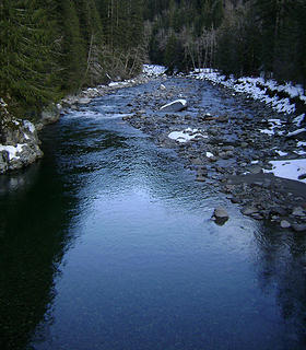 North Fork Sky, upstream from bridge to Mineral Butte and Mineral City access roads 1/28/17 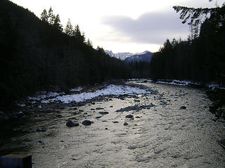 View downstream from the bridge to Mineral Butte and Mineral City access roads 1/28/17 |
|
|
| Back to top |
|
|
ale_capone
Member

Joined: 22 Sep 2009
Posts: 720 | TRs | Pics
|
Drove to 6310 on bare pavement last night. I would imagine it's good to trout Creek, where the washout is. Sounds like it's also where Nancy Ann parked.
Everything off road is snow covered at about 1,000'.
|
| Back to top |
|
|
Nancyann
Member
Joined: 28 Jul 2013
Posts: 2318 | TRs | Pics
Location: Sultan Basin |
|
Nancyann
Member
|
Sun Feb 12, 2017 12:40 pm |
|
|
Thanks for the update, ale_capone! Yes, the washout is just past the Trout Creek gated road.
The bypass route we took past there to the other side is no longer possible due to too much water in the N. Fork Sky. It is possible to access Iron Mt. and the mines a little ways up Trout Creek before the washout though. 
|
| Back to top |
|
|
JonnyQuest
Member
Joined: 10 Dec 2013
Posts: 593 | TRs | Pics
|
Here's a site that sometimes has up-to-date info on the NF Sky road.
http://skyko.org/
|
| Back to top |
|
|
|
|
You cannot post new topics in this forum
You cannot reply to topics in this forum
You cannot edit your posts in this forum
You cannot delete your posts in this forum
You cannot vote in polls in this forum
|
Disclosure: As an Amazon Associate NWHikers.net earns from qualifying purchases when you use our link(s). |


