| Previous :: Next Topic |
| Author |
Message |
RichP
Member


Joined: 13 Jul 2006
Posts: 5634 | TRs | Pics
Location: here |
|
RichP
Member
|
 Wed Feb 15, 2017 8:43 am |
|
|
Puzzlr, Snowdog, Isabel and I took the long drive over the Cascades to Ellensburg and went south on Canyon Road to the Umtanum Creek Recreation Area. We started the hike in a chilly 15 degrees by crossing the Yakima River on a suspension bridge.
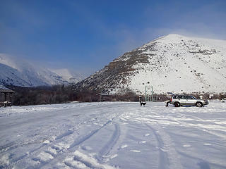 Umtanum Canyon Trailhead. 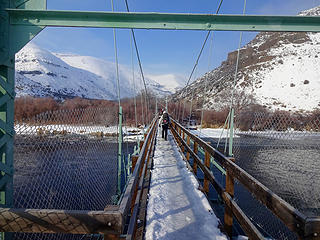 Crossing the Yakima River. 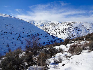 We will head up the ridge to the right. 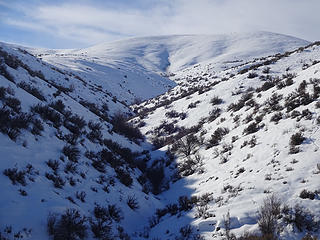 Starting up the ridge. 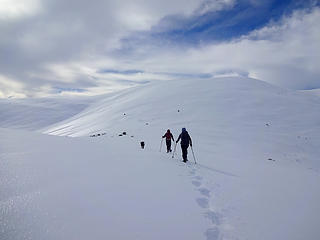 A crusty layer with powder underneath made for tedious snowshoeing conditions. 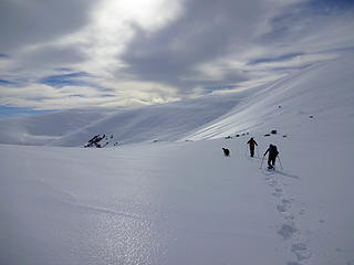 Pushing up the ridge. 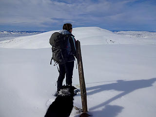 Snowdog and Izzy at Point 3511'. Wenas Benchmark is the next bump on the ridge. 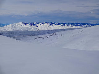 Cleman Mtn to the south across the Wenas Valey. 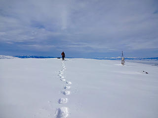 Puzzlr arriving to Wenas Benchmark 3630.' 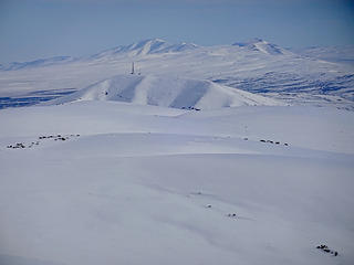 View Southeast from Wenas Benchmark. Baldy and Hog Ranch Buttes in the distance; more highpoints on the 55-mile long Umtanum Ridge. . 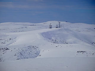 West to Rattler Benchmark beyond the antennas. 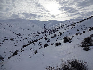 Almost down.
|
| Back to top |
  
|
|
lookout bob
WTA proponent.....

Joined: 12 Apr 2005
Posts: 3043 | TRs | Pics
Location: wta work while in between lookouts |
|
lookout bob
WTA proponent.....
|
Wed Feb 15, 2017 12:11 pm |
|
|
I thought the ticks jump up through the snow to grab a meal..... 
"Altitude is its own reward"
John Jerome ( from "On Mountains")
"Altitude is its own reward"
John Jerome ( from "On Mountains")
|
| Back to top |
|
|
RichP
Member
Joined: 13 Jul 2006
Posts: 5634 | TRs | Pics
Location: here |
|
RichP
Member
|
Wed Feb 15, 2017 12:40 pm |
|
|
| lookout bob wrote: | | I thought the ticks jump up through the snow to grab a meal..... |
I was hiking in the snow last year in Feb near Blewett Pass and found several on me, so you must be right.
|
| Back to top |
|
|
Snowdog
Member

Joined: 21 Jul 2006
Posts: 1028 | TRs | Pics
Location: on (& off) the beaten path |
|
Snowdog
Member
|
Wed Feb 15, 2017 12:51 pm |
|
|
Really fun & interesting outing! It sure felt like more yesterday than the stats suggest. The constant punching thru thick ice layer, then down a foot or more of soft snow made for tedious travel. Isabel had a challenging day too, hopping from one snowshoe step to the next. Good thing she is an agility dog!  Such expansive views too- love eastern Washington's big sky!
'we don't have time for a shortcut'
'we don't have time for a shortcut'
|
| Back to top |
|
|
GaliWalker
Have camera will use

Joined: 10 Dec 2007
Posts: 4929 | TRs | Pics
Location: Pittsburgh |
|
GaliWalker
Have camera will use
|
Wed Feb 15, 2017 1:11 pm |
|
|
Woah! I'm sure that people post them, but I don't think I've seen snowy pictures from there before. Really nice! 
|
| Back to top |
|
|
puzzlr
Mid Fork Rocks

Joined: 13 Feb 2007
Posts: 7220 | TRs | Pics
Location: Stuck in the middle |
|
puzzlr
Mid Fork Rocks
|
Thu Feb 16, 2017 1:33 pm |
|
|
This was my first significant hike after mostly recovering from a 2 week cold I caught in Guatemala, although there seems to be an abundance of that going around here too. Having done this hike before exactly 6 years ago without any snow I expected a fairly easy day. But with the vastly different snow conditions this turned out to be a real work out. It needed all three of us to break trail in the icy crust.
A few of my favorite photos, more on flickr
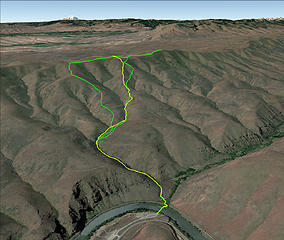 Green is our GPS track, yellow is the trail route when not covered in snow 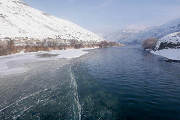 Ice on the Yakima River 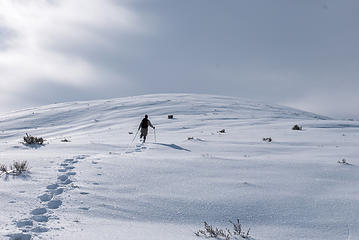 It looks like we're almost there but there's still almost 500' of gain to go  The icy crust glittered beautifully in the sunlight 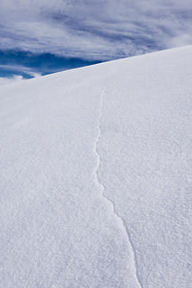 One of the long cracks in the thin icy crust. On a glacier this would be concerning, showing the possible presence of a crevasse. 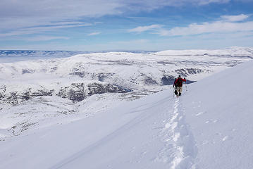 Traversing over to the ridge that the trail runs down (but under the snow and not visible today) 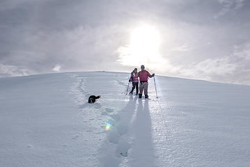 Descending the ridge. The icy crust made a lot of noise first as our snowshoes broke through it, then as broken pieces slid down the slope in front of us. 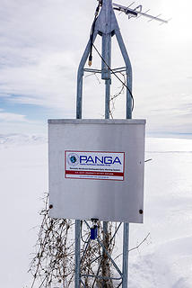 WENA PANGA station 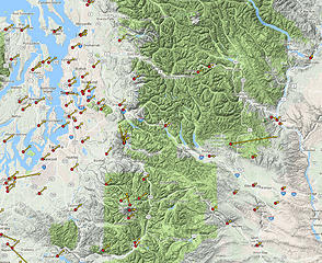 Central WA velocity map 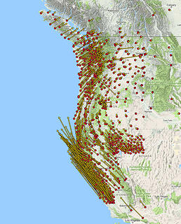 West coast velocity map
|
| Back to top |
|
|
wildernessed
viewbagger

Joined: 31 Oct 2004
Posts: 9275 | TRs | Pics
Location: Wenatchee |
Living in the Anthropocene
Living in the Anthropocene
|
| Back to top |
|
|
|
|


