| Previous :: Next Topic |
| Author |
Message |
markweth
Member


Joined: 08 Feb 2017
Posts: 155 | TRs | Pics
Location: Montana |
|
markweth
Member
|
 Wed Jun 21, 2017 3:16 pm |
|
|
WOW! Talk about an adventure . . . I cut a wide swath through the Wenaha-Tucannon Wilderness over three nights/four days and somewhere in the neighborhood of 56 miles. Some parts of the trip were great, others were absolutely terrific, and others were simply maddening. None of it was boring and most of it was awesome.
Here goes . . .
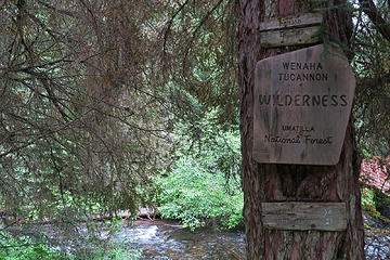 Wenaha-Tucannon Wilderness, Umatilla National Forest, Washington. 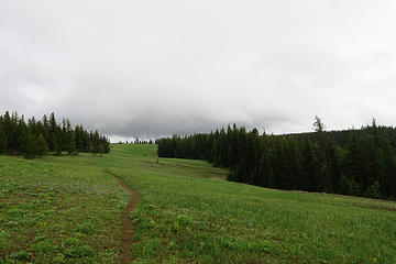 Wenaha-Tucannon Wilderness, Umatilla National Forest, Washington. 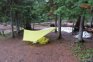 Wenaha-Tucannon Wilderness, Umatilla National Forest, Washington. 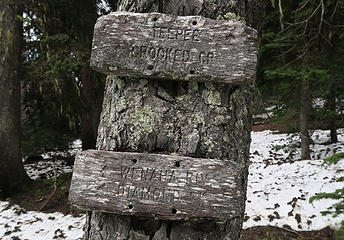 Wenaha-Tucannon Wilderness, Umatilla National Forest, Washington. 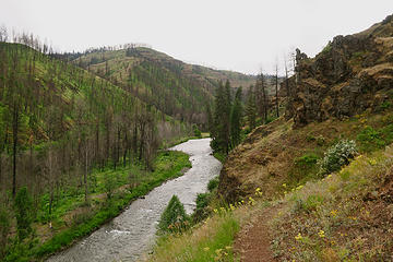 Wenaha-Tucannon Wilderness, Umatilla National Forest, Washington. 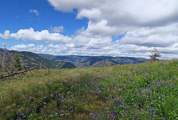 Wenaha-Tucannon Wilderness, Umatilla National Forest, Washington. 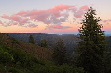 Wenaha-Tucannon Wilderness, Umatilla National Forest, Washington. 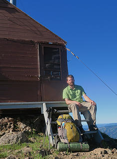 Wenaha-Tucannon Wilderness, Umatilla National Forest, Washington. 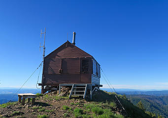 Wenaha-Tucannon Wilderness, Umatilla National Forest, Washington.
|
| Back to top |
  
|
|
Ski
><((((°>

Joined: 28 May 2005
Posts: 12831 | TRs | Pics
Location: tacoma |
|
Ski
><((((°>
|
Wed Jun 21, 2017 3:28 pm |
|
|
 looks SO different when it's all green! wow!
"I shall wear white flannel trousers, and walk upon the beach.
I have heard the mermaids singing, each to each."
"I shall wear white flannel trousers, and walk upon the beach.
I have heard the mermaids singing, each to each."
|
| Back to top |
|
|
texasbb
Misplaced Texan
Joined: 30 Mar 2009
Posts: 1153 | TRs | Pics
Location: Tri-Cities, WA |
|
texasbb
Misplaced Texan
|
Wed Jun 21, 2017 5:05 pm |
|
|
Love it! I did the same loop in 2009 and found it similarly enjoyable. Melton Creek trail is great (and the sign wasn't much clearer back then either). I came up on a small blackie hiking ahead of me; had to finally shoo him off 'cause he was going too slow.  I still had a bridge over Crooked Creek. I camped right there at the Crooked/Wenaha confluence and saw that night the brightest blazing starry night I've ever seen, and I've seen a few. Smooth Ridge was hard to follow even before the fire, so I can imagine it's challenging now.
One difference is I took Turkey Creek trail to rejoin Panjab on the way out.
The filthy hunters camps are out of control and have been for years. I should post a photo essay. I still had a bridge over Crooked Creek. I camped right there at the Crooked/Wenaha confluence and saw that night the brightest blazing starry night I've ever seen, and I've seen a few. Smooth Ridge was hard to follow even before the fire, so I can imagine it's challenging now.
One difference is I took Turkey Creek trail to rejoin Panjab on the way out.
The filthy hunters camps are out of control and have been for years. I should post a photo essay.  Thanks for sharing and stirring up memories. I love the W-T.
|
| Back to top |
|
|
Pyrites
Member

Joined: 16 Sep 2014
Posts: 1884 | TRs | Pics
Location: South Sound |
|
Pyrites
Member
|
Thu Jun 22, 2017 4:13 pm |
|
|
WTA did a BCRT in April this year. They also did a project on the Wilderness in 2016.
We logged out Panjab, Turkey, and Rattlesnake to the snow line. We also did a heavy brushing on Panjab, a little tread, as well as some brushing and a little tread on Rattlesnake. I think if snow line had been higher more work would have been focused on Panjab. This is the one the FS cares about most.
WTA plans to go back next year.
Keep Calm and Carry On?
Heck No.
Stay Excited and Get Outside!
Keep Calm and Carry On?
Heck No.
Stay Excited and Get Outside!
|
| Back to top |
|
|
texasbb
Misplaced Texan
Joined: 30 Mar 2009
Posts: 1153 | TRs | Pics
Location: Tri-Cities, WA |
|
texasbb
Misplaced Texan
|
Thu Jun 22, 2017 7:44 pm |
|
|
| Pyrites wrote: | | We logged out Panjab, Turkey, and Rattlesnake to the snow line. We also did a heavy brushing on Panjab, a little tread, as well as some brushing and a little tread on Rattlesnake. I think if snow line had been higher more work would have been focused on Panjab. This is the one the FS cares about most. |
Thanks! And you're right, Panjab is the one that gets all the traffic. It's still quite a mess up near the top, at least it was on Thanksgiving. And Rattlesnake is almost impossible to follow in the burn area west of Red Fir Spring, for anyone who's not familiar with it. But those two trails make for one of the best day-hikable loops in the area, so all logging efforts are greatly appreciated.
Edit: Corrected name of spring.
|
| Back to top |
|
|
markweth
Member
Joined: 08 Feb 2017
Posts: 155 | TRs | Pics
Location: Montana |
|
markweth
Member
|
Fri Jun 23, 2017 12:40 pm |
|
|
| Pyrites wrote: | | WTA did a BCRT in April this year. They also did a project on the Wilderness in 2016.
We logged out Panjab, Turkey, and Rattlesnake to the snow line. We also did a heavy brushing on Panjab, a little tread, as well as some brushing and a little tread on Rattlesnake. I think if snow line had been higher more work would have been focused on Panjab. This is the one the FS cares about most.
WTA plans to go back next year. |
Thanks for the work! Panjab Trail was certainly delightful hiking.
Any idea if there are plans to do work on the trail from Fairview Bar to Smooth Ridge? That section was almost impossible to follow after it left the open slopes of the hillside and entered the recently burned forest.
The Wenaha River Trail looked like it had recent work done on it between Crooked Creek and Fairview Bar. What a wonderful section of trail, great upstream views and pleasant walking.
|
| Back to top |
|
|
FiresideChats
Member
Joined: 20 Jan 2014
Posts: 363 | TRs | Pics
Location: San Juan Islands |
This stirred up a fond memory of a sunset on top of Oregon Butte when I was just starting to explore the wild. I also remember looking south from the Butte into Oregon and all those wild mountains stretched out in a green and purple hue in the evening light. Love that area.
|
| Back to top |
|
|
glenoid
Member

Joined: 30 Oct 2012
Posts: 307 | TRs | Pics
|
|
glenoid
Member
|
Sat Jun 24, 2017 7:40 am |
|
|
Nice trip! Didn't you just love the wetter areas and the brush?? If you go back to explore the west side of the Wenaha, you will have clear trails above the river, but once you are down on the Wenaha itself, expect brushwacking. As for Dusty Camp it is used by the guide in this area. (It even exists, because Picket spring is just below the trail and camp.) The camp is cleaner some years then others. Most people do use the Panjab trail in this area. (It should be noted that the guide in this area logs out the Panjab long before Memorial day, and way before the forest service crews ever arrive. Last year's trail work was a easier because of all the work he has done over the years on the Panjab.)
I think Squaw springs is a dive. But the water there us easy to get at. Sheephead Corral is dry but cleaner. Had a group of 50 or so cow/calf elk walk through our camp there once.
I would also say that about 90% of trail junctions in Wenaha-Tucannon Wilderness are not signed. You are on your own....
|
| Back to top |
|
|
DIYSteve
seeking hygge

Joined: 06 Mar 2007
Posts: 12655 | TRs | Pics
Location: here now |
|
DIYSteve
seeking hygge
|
Sat Jun 24, 2017 8:37 am |
|
|
Good trip and write up. Such a cool area. W-T WA has some true wilderness and quite different than other WAs in the PNW.
|
| Back to top |
|
|
|
|
You cannot post new topics in this forum
You cannot reply to topics in this forum
You cannot edit your posts in this forum
You cannot delete your posts in this forum
You cannot vote in polls in this forum
|
Disclosure: As an Amazon Associate NWHikers.net earns from qualifying purchases when you use our link(s). |


