| Previous :: Next Topic |
| Author |
Message |
bertman
Member


Joined: 17 Jul 2006
Posts: 362 | TRs | Pics
|
|
bertman
Member
|
 Mon Aug 14, 2017 4:32 pm |
|
|
So hoping to get down to Oregon to view the total solar eclipse. Trying to figure out where to go backpacking. Apparently the Whitewater fire has closed down Mount Jefferson and Jefferson Park. I spoke with the ranger at Detroit Ranger Station and they suggested Marion Lake as an option. However, it looks like that is a readily accessible destination and I am certain it is going to be crowded.
Does anyone have any recommendations for a little less traveled backpacking destination off of Hwy 22 or Hwy 20? I'm probably driving south from Seattle on Saturday and hopefully start backpacking in. I'm willing to go up to 10 miles if need be.
Thanks!
|
| Back to top |
  
|
|
John Morrow
Member

Joined: 03 Apr 2007
Posts: 1526 | TRs | Pics
Location: Roslyn |
I am guessing you are but I'd monitor the smoke for the next few days if the weather pattern isn't expected to change. It may help steer you to a good backcountry location. No sense all that effort to be occluded....
Wouldn't be surprised if Marion Lake ended up in the fire closure as it seems to be creeping/moving south
I fI had it off I'd try the Mt Sutton WSA by the Fossil Beds. Water polished canyon to the east leads to the summit it appears. Like, who's heard of that place?????
Tell me, what is it you plan to do with your one wild and precious life?-Mary Oliver
A nation that continues year after year to spend more money on military defense than on programs of social uplift is approaching spiritual doom.
― MLK Jr.
Tell me, what is it you plan to do with your one wild and precious life?-Mary Oliver
A nation that continues year after year to spend more money on military defense than on programs of social uplift is approaching spiritual doom.
― MLK Jr.
|
| Back to top |
|
|
Snowday
Member

Joined: 13 Aug 2010
Posts: 120 | TRs | Pics
Location: Ellensburg, Park City, Bend, etc. |
|
Snowday
Member
|
Tue Aug 15, 2017 8:36 am |
|
|
I'd go over Santiam Pass and then I'd hike in to Carl Lake, camp there the night before and go up to the PCT and find a place along the ridge to view the eclipse. This is southeast of Mt. Jefferson. I'd expect plenty of company. Carl Lake is my favorite lake in the area. I'd be there if it weren't for some health issues -- you can have my spot  Some good alternatives would be hiking into Canyon Creek Meadows and Three Fingered Jack (or Wasco Lake). There are also options to hike north (Square or Booth Lakes) or south (Patjens Lakes, Mt. Washington). I'd expect the closer to the pass, the more crowded it will be (might be able to Park at Hoo Doo ski area).
Have fun!
Edit: the southern options will have less time in the dark.
Some good alternatives would be hiking into Canyon Creek Meadows and Three Fingered Jack (or Wasco Lake). There are also options to hike north (Square or Booth Lakes) or south (Patjens Lakes, Mt. Washington). I'd expect the closer to the pass, the more crowded it will be (might be able to Park at Hoo Doo ski area).
Have fun!
Edit: the southern options will have less time in the dark.
|
| Back to top |
|
|
grannyhiker
Member

Joined: 29 Jul 2006
Posts: 3519 | TRs | Pics
Location: Gateway to the Columbia Gorge |
Carl Lake is closed--all the trails into the Mt. Jeff Wilderness on both sides of the mountains, except for a few at the very south end, are closed. The Cabot Lake trail is one of these that is closed. Official closure notice per InciWeb
Map:
The Hoodoo Ski area is the fire camp for the Whitewater fire, so that's closed, too.
Most of the Three Sisters Wilderness was just closed last night, too. Closure notice on InciWeb
It's a good idea to check InciWeb before making any plans!
I'm worried about the smoke, too--we have campsites reserved on the Metolius River.
May your trails be crooked, winding, lonesome, dangerous, leading to the most amazing view.--E.Abbey
May your trails be crooked, winding, lonesome, dangerous, leading to the most amazing view.--E.Abbey
|
| Back to top |
|
|
Sore Feet
Member

Joined: 16 Dec 2001
Posts: 6307 | TRs | Pics
Location: Out There, Somewhere |
Also keep in mind that most, if not all, estimates have suggested that as many as a million people are going to descent on the path of totality in Oregon. I think (hope) most of that will be confined to the Salem area, Madras, and the coast, but it's going to be a mad house regardless.
|
| Back to top |
|
|
zephyr
aka friendly hiker

Joined: 21 Jun 2009
Posts: 3370 | TRs | Pics
Location: West Seattle |
|
zephyr
aka friendly hiker
|
Wed Aug 16, 2017 10:28 am |
|
|
Today there's an article in the Seattle Times warning of the various congested roads. There's a map of the many Columbia River crossings on major roadways. Quote: If youre entertaining the idea of popping in your car really early Monday and racing down to Oregon in time for the eclipse, think again.
Youre not the only person thinking that most everybody else will have heeded the dire traffic warnings from both Oregon and Washington, and that you and the other spontaneous types will have the roads to yourselves.
And you arent the only person whos pored over maps looking for those little-known, lightly traveled alternate routes on the eastern side of both states.
If you try to come down Monday, no matter how early you leave, youre already too late, said Oregon Department of Transportation (ODOT) spokesman Dave Thompson, whose agency has been planning for eclipse traffic for more than a year.
...
In trying to anticipate what people will do as they head toward the first total eclipse of the sun in the United States since 1979, Thompson and his colleagues have examined virtually every highway in Eastern Washington and most are narrow, two-lane, curving rural roads which will not get you into the eclipses path with any speed or ease, he said.
More information and suggestions in the article. I will probably post this in another thread as well. ~z
|
| Back to top |
|
|
boot up
Old Not Bold Hiker

Joined: 12 Dec 2006
Posts: 4745 | TRs | Pics
Location: Bend Oregon |
|
boot up
Old Not Bold Hiker
|
Wed Aug 16, 2017 12:10 pm |
|
|
and a big plume of smoke is still visible in the Jefferson Wilderness area.
|
| Back to top |
|
|
bertman
Member
Joined: 17 Jul 2006
Posts: 362 | TRs | Pics
|
|
bertman
Member
|
Wed Aug 16, 2017 12:26 pm |
|
|
Thanks for the replies, folks. I'm trying to avoid the traffic charlie foxtrot by driving down on Saturday and backpacking for two nights. But those closures are getting worse. I think at this point my best bet is to get to the Detroit Ranger Station and ask before backpacking in.
|
| Back to top |
|
|
John Morrow
Member
Joined: 03 Apr 2007
Posts: 1526 | TRs | Pics
Location: Roslyn |
| boot up wrote: | | and a big plume of smoke is still visible in the Jefferson Wilderness area. |
Take a pic and post!
Tell me, what is it you plan to do with your one wild and precious life?-Mary Oliver
A nation that continues year after year to spend more money on military defense than on programs of social uplift is approaching spiritual doom.
― MLK Jr.
Tell me, what is it you plan to do with your one wild and precious life?-Mary Oliver
A nation that continues year after year to spend more money on military defense than on programs of social uplift is approaching spiritual doom.
― MLK Jr.
|
| Back to top |
|
|
xrp
Tactical Backpacker

Joined: 01 May 2012
Posts: 369 | TRs | Pics
|
|
xrp
Tactical Backpacker
|
Wed Aug 16, 2017 5:42 pm |
|
|
If you haven't already parked at your trailhead, you're too late.
1,000,000+ people from the Seattle area are already planning to do the same thing as you -- at the same time. Think about that for a minute.
Roads at a standstill for miles.
Trailheads overflowing.
Overflow of people on the trails, in the woods and cramping into campsites.
Here's what it looks like (spoiler):
|
| Back to top |
|
|
pcg
Member

Joined: 09 Jun 2012
Posts: 334 | TRs | Pics
|
|
pcg
Member
|
Wed Aug 16, 2017 6:07 pm |
|
|
|
| Back to top |
|
|
boot up
Old Not Bold Hiker
Joined: 12 Dec 2006
Posts: 4745 | TRs | Pics
Location: Bend Oregon |
|
boot up
Old Not Bold Hiker
|
Wed Aug 16, 2017 8:22 pm |
|
|
Dang.....a spoiler pic. Not even worth going outside now.  Gas stations in Redmond OR are already running out of gas. LONG lines at the pumps in Bend already. I gassed up our cars yesterday and it was no problem. It is like someone flipped a switch on traffic coming in today.
And the absolute worst disaster.......... The Bend Costco ran out of frozen pizzas yesterday.
Gas stations in Redmond OR are already running out of gas. LONG lines at the pumps in Bend already. I gassed up our cars yesterday and it was no problem. It is like someone flipped a switch on traffic coming in today.
And the absolute worst disaster.......... The Bend Costco ran out of frozen pizzas yesterday.  There may be riots over that one.
I notice mail delivery has stopped There may be riots over that one.
I notice mail delivery has stopped
|
| Back to top |
|
|
boot up
Old Not Bold Hiker
Joined: 12 Dec 2006
Posts: 4745 | TRs | Pics
Location: Bend Oregon |
|
boot up
Old Not Bold Hiker
|
Wed Aug 16, 2017 9:14 pm |
|
|
Sunset tonight looking towards Metolius/Sisters/Jefferson wilderness from my front porch.
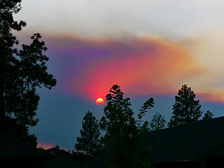 Smoky sunset Bend OR, 8/16/17 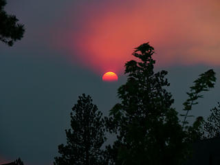 Smoky sunset Bend OR, 8/16/17 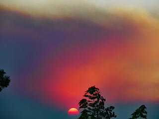 Smoky sunset Bend OR, 8/16/17 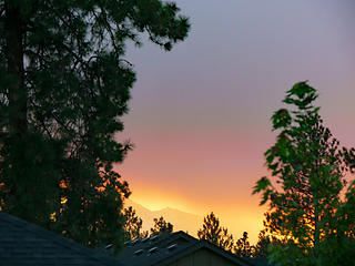 Smoky sunset Bend OR, 8/16/17  I forgot to mention that Tripcheck is you friend in Oregon. I will be watching it a lot just for entertainment, and also my daughters are driving from Seattle on Saturday, contrary to my recommendation to skip it.
|
| Back to top |
|
|
grannyhiker
Member
Joined: 29 Jul 2006
Posts: 3519 | TRs | Pics
Location: Gateway to the Columbia Gorge |
That looks lovely (sarcasm). The smoke forecast for Sisters (the town nearest the Metolius) is "moderate" which is, I believe, what it was Aug. 2-3 when I was there. If it gets worse, I'll bail out, if I can get out. I'm told I'm in one of the "sensitive groups."
I'm more concerned about the rest of my family who are arriving Saturday. I tried to persuade them to come sooner, but no luck. My eldest son and his wife fly into PDX tomorrow morning and we're heading out right away.
May your trails be crooked, winding, lonesome, dangerous, leading to the most amazing view.--E.Abbey
May your trails be crooked, winding, lonesome, dangerous, leading to the most amazing view.--E.Abbey
|
| Back to top |
|
|
John Morrow
Member
Joined: 03 Apr 2007
Posts: 1526 | TRs | Pics
Location: Roslyn |
| boot up wrote: | Smoky sunset Bend OR, 8/16/17 Smoky sunset Bend OR, 8/16/17 Smoky sunset Bend OR, 8/16/17 Smoky sunset Bend OR, 8/16/17 |
| boot up wrote: | | I forgot to mention that Tripcheck is you friend in Oregon. |
Indeed, and thanks for the pics!
Tell me, what is it you plan to do with your one wild and precious life?-Mary Oliver
A nation that continues year after year to spend more money on military defense than on programs of social uplift is approaching spiritual doom.
― MLK Jr.
Tell me, what is it you plan to do with your one wild and precious life?-Mary Oliver
A nation that continues year after year to spend more money on military defense than on programs of social uplift is approaching spiritual doom.
― MLK Jr.
|
| Back to top |
|
|
|
|


