| Previous :: Next Topic |
| Author |
Message |
ArcDome
Member


Joined: 30 Jun 2006
Posts: 285 | TRs | Pics
|
|
ArcDome
Member
|
 Tue Sep 05, 2017 8:24 am |
|
|
I do not think there is an immediate threat but a level 1 evacuation notification has been listed for Lost River, Mazama, and Rendezvous.
| Quote: | | Diamond Creek Fire September 5
Incident: Diamond Creek Fire Wildfire
Released: 10 min. ago
Fire crests Butte Pass; Level 1 evacuations ordered
Acres: 85,000 US; 10,000 Canada
Location: 12 miles north of Mazama, WA
Completion: 65%
Total Personnel: 50
Yesterday: Firefighters reported moderate spread to the east and north in the Spanish Creek and Ashonola Creek areas. To the southwest, the fire crested over Butte Pass but remained hung up in the upper reaches of the Monument Creek area in extremely rocky terrain. An inversion resulted in heavy smoke, severely limiting air resources. From the start, the extreme terrain and fuel loading has limited the direct response actions that might normally be taken to put out a fire, said Acting District Ranger, Erin Uloth. Crews have been working for weeks to protect our communities and we will continue to do so where it is safe to engage this fire. Today: Fire managers are anticipating a shift in winds to the southeast resulting in potentially less new growth in the Monument Creek, Remmel Lake and Ptarmigan Creek areas. However, another day of critical fire weather and an abundance of dead and down timber may result in continued fire spread to the west and northwest. Helicopter and ground crews will be utilized as it is safe to do so. Due to continued fire growth and smoke, a community meeting is scheduled for Wednesday September 6, 2017 from 6pm-7pm at the Red Barn in Winthrop. Fire managers will be available to provide detailed information and maps.
Evacuations: Level 1 evacuations are now in effect for the communities of Lost River, Mazama, and Rendezvous. Residents of these areas should be aware there is a potential threat to the area and make plans for possible evacuations.
Closures: There are currently more than 60 roads or trails closed for public safety including Monument Trail #484 and Andrews Creek #504. Complete closure details and maps are available at inciweb.nwcg.gov/incident/5409/.
Weather: This is the 65 consecutive day without precipitation over much of Central Washington. Near record high temperatures and critically low humidity will continue through mid-week.
Fire Restrictions: Fire restrictions remain in place. Maintaining, attending, or using a fire or campfire, and use of charcoal briquette barbecues, or other devices that use solid fuel is prohibited across the Okanogan-Wenatchee National Forest. An Industrial Fire Precaution Level III is in effect which does not allow any firewood cutting with a power saw for commercial or personal use. |
|
| Back to top |
  
|
|
Bedivere
Why Do Witches Burn?

Joined: 25 Jul 2008
Posts: 7464 | TRs | Pics
Location: The Hermitage |
|
Bedivere
Why Do Witches Burn?
|
Tue Sep 05, 2017 12:05 pm |
|
|
Interesting. The fire hasn't shown any growth to the South in quite some time.
|
| Back to top |
|
|
gb
Member

Joined: 01 Jul 2010
Posts: 6309 | TRs | Pics
|
|
gb
Member
|
Tue Sep 05, 2017 1:10 pm |
|
|
95,000 acres this morning, up 10,000 acres overnight. Isn't that about 1/5th of the Pasayten Wilderness?
|
| Back to top |
|
|
sooperfly
Member

Joined: 04 May 2003
Posts: 1234 | TRs | Pics
Location: North Central Wa. |
| gb wrote: | | 95,000 acres this morning, up 10,000 acres overnight. Isn't that about 1/5th of the Pasayten Wilderness? |
10K of that total are in Canada. Not that it looks like it's slowing down any time soon, I'm sure before it's done it will be well over 100K. 
|
| Back to top |
|
|
BeyondLost
Crazy Bob
Joined: 07 Jul 2007
Posts: 3601 | TRs | Pics
Location: Whidbey Island, WA |
A neighbor at Beyond Lost sent me this from the meeting last night.
"When the fire has reached the respective lines, they will give the evacuation notices ...
The black dots represent fire breaks they're either working on or old ones ... They said the only one they're considering right now is from Yellowjacket up the hill and then following the road to the east ...so doesn't help us much ...
The question was raised about adequate fire personnel, and they say they've put requests in for more, but due to the other fires and hurricanes, there aren't enough resources to go around, either people or equipment."
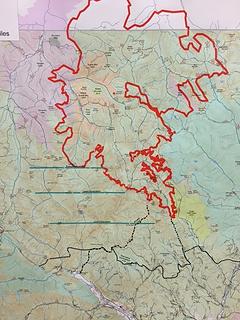 image1.JPG
|
| Back to top |
|
|
Joey
verrry senior member

Joined: 05 Jun 2005
Posts: 2797 | TRs | Pics
Location: Redmond |
|
Joey
verrry senior member
|
Thu Sep 07, 2017 7:44 pm |
|
|
MODIS shows fire is moving south and has burned the upper part of Monument Creek drainage. That creek leads into Lost River. Light wind is forecast out of the NW which is exactly what we do not want to see.
|
| Back to top |
|
|
BeyondLost
Crazy Bob
Joined: 07 Jul 2007
Posts: 3601 | TRs | Pics
Location: Whidbey Island, WA |
Yes, the modis map shows the fire has moved south about half way between the level 1 and level 2 fire evacuation lines. By my rough estimate.
EDIT:
Just saw this on the Diamond Creek FB page from last night. It looks inevitable that evacuation notices will be out in 1-2 days.
"Aerial reconnaissance this afternoon over the Diamond Creek Fire reports the fire has backed into the Monument Creek drainage and is approximately 1-1 1/2 miles from the Level 2 action decision line."
|
| Back to top |
|
|
BeyondLost
Crazy Bob
Joined: 07 Jul 2007
Posts: 3601 | TRs | Pics
Location: Whidbey Island, WA |
Photo this afternoon from Beyond Lost. Hikers and high hunters are being warned of the possibility Harts Pass Rd might be closed and exit via Rainy Pass.
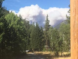 image2.JPG
|
| Back to top |
|
|
pasayten
Class of 65...

Joined: 18 Aug 2011
Posts: 536 | TRs | Pics
Location: Winthrop, WA |
|
pasayten
Class of 65...
|
Mon Sep 11, 2017 5:47 pm |
|
|
| BeyondLost wrote: | | Photo this afternoon from Beyond Lost. |
That is looking very close...
Attention PCT Hikers and High Hunters: Hart's Pass Pacific Crest Trail Pickup Point Affected by Diamond Creek
The Pacific Crest Trail (PCT) and Hart's Pass Road, which provides the northernmost motorized access point on the PCT, are currently open. Should fire activity increase, the PCT and/or Hart's Pass Road could be affected and may be closed to the public. The alternate pickup point for PCT hikers, if the Hart's Pass Road is closed, would be Rainy Pass on Highway 20. Please be prepared for the potential needs to reroute your egress from the Pasayten Wilderness.
Any trail or road closures will be updated daily by the US Forest Service and posted on their fire website. For more information, contact the Diamond Creek Fire at:
Diamond Creek Fire Information: 509-996-4040
Website: https://inciweb.nwcg.gov/incident/5409/
Automated Updates: diamondcreekfire.blogspot.com
Facebook: diamondcreekfire2017
|
| Back to top |
|
|
BeyondLost
Crazy Bob
Joined: 07 Jul 2007
Posts: 3601 | TRs | Pics
Location: Whidbey Island, WA |
Screen shot of Modis map this PM. Very active and may have passed Level 2 evacuation.
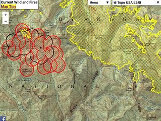 Screen Shot 2017-09-11 at 7.43.12 PM.png
|
| Back to top |
|
|
Fletcher
Member

Joined: 29 Jul 2009
Posts: 1870 | TRs | Pics
Location: kirkland |
|
Fletcher
Member
|
Tue Sep 12, 2017 7:08 am |
|
|
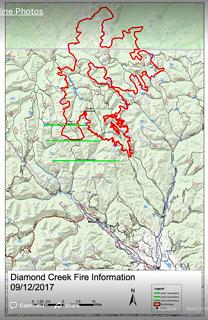
Oh man, looks like the fire is certainly destroying Monument Creek at this point. Really hoping the forecasted rain rolls in next week.
|
| Back to top |
|
|
RichP
Member

Joined: 13 Jul 2006
Posts: 5634 | TRs | Pics
Location: here |
|
RichP
Member
|
Tue Sep 12, 2017 11:45 am |
|
|
Whoa. Lake of the Woods will be no more.
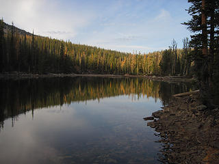 Lake of the Woods 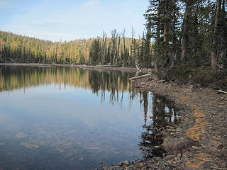 Lake of the Woods 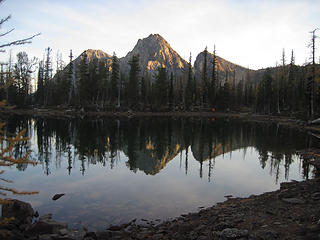 Pistol Peaks from Lake of the Woods 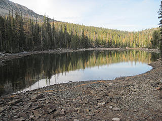 Lago del Bosque 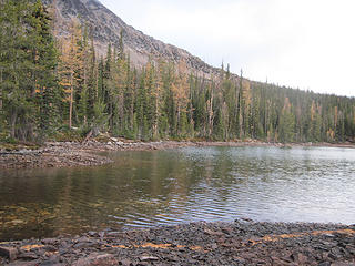 Lake of the Woods the morning after
|
| Back to top |
|
|
BeyondLost
Crazy Bob
Joined: 07 Jul 2007
Posts: 3601 | TRs | Pics
Location: Whidbey Island, WA |
It is Level 2 this AM. Wind from the north will continue to push it south. Rain possible by Sunday. Hope we have that long.
""Incident prioritization worksheet social/political considerations moderate. The Pasayten Wilderness is closed east of the PCT. this will impact the high country hunt 9/15 through 9/25. Level 2 evacuation notifications will be implemented on 9/13. The PCT may need to be closed at a later date. the incident has been active for 51 days and has been through multiple transitions and managed at the type 1,2,3 and 4 levels. The current type 3 team has held multiple cooperator meetings, a community meeting attended by 377 people, and will host a second community meeting on 9/13."
 Screen Shot 2017-09-13 at 5.15.09 AM.png
|
| Back to top |
|
|
Gil
Member

Joined: 29 Sep 2004
Posts: 4062 | TRs | Pics
|
|
Gil
Member
|
Wed Sep 13, 2017 11:56 am |
|
|
Friends help the miles go easier.
Klahini
|
| Back to top |
|
|
sooperfly
Member
Joined: 04 May 2003
Posts: 1234 | TRs | Pics
Location: North Central Wa. |
Harts Pass road is now closed.
Closures: The Harts Pass Road is now closed at the Forest Boundary beyond the Lost River Airport. The PCT is still open, but the access is now Rainy Pass trailhead or Canyon Creek trailhead. The trailheads of Robinson Creek and Rattlesnake are also closed.
The Ballard and River Bend campgrounds are now also closed
|
| Back to top |
|
|
|
|


