| Previous :: Next Topic |
| Author |
Message |
Bedivere
Why Do Witches Burn?


Joined: 25 Jul 2008
Posts: 7464 | TRs | Pics
Location: The Hermitage |
|
Bedivere
Why Do Witches Burn?
|
 Fri Sep 15, 2017 12:17 pm |
|
|
This fire has taken out many of my favorite places in the Pasayten and a few that I haven't had a chance to get to yet but were on my "to do" list. I'm hopeful the rains will get here before it reaches Tungsten Mine. Losing those cabins would be a terrible shame.
The fire permiter makes it looks like it's burned right up to the Eastern shore of lower Dot lake. Such a shame, that was a really nice and very rarely used camp spot among a magnificent Larch grove. I'd really wanted to go back there in the fall one of these years soon.
|
| Back to top |
  
|
|
sooperfly
Member

Joined: 04 May 2003
Posts: 1234 | TRs | Pics
Location: North Central Wa. |
| Bedivere wrote: | | The fire permiter makes it looks like it's burned right up to the Eastern shore of lower Dot lake. Such a shame, that was a really nice and very rarely used camp spot among a magnificent Larch grove. I'd really wanted to go back there in the fall one of these years soon. |
I visited Dot in 2012.. shame if all these burnt up..... 
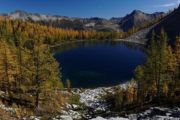 Lower Dot
|
| Back to top |
|
|
BeyondLost
Crazy Bob

Joined: 07 Jul 2007
Posts: 3601 | TRs | Pics
Location: Whidbey Island, WA |
The Diamond Creek fire is up to 122,000 acres but the southward point has come to rocky slopes which will slow it. The winds have dropped, temps are down and Sunday rain and/or snow are predicted. The fire is about 2 miles from Level 3 and 6-7 miles from us. Fire fighters were on our property the last two days preparing a fire line, back burn scenario and clearing snags on the mountain side(Scramble) next to us. 6-7 miles sounds like a lot but the Carlton fire two years ago ran 9 miles in 8 hours when the wind came up unexpectedly.
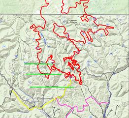 Fire Map 9:15.png
|
| Back to top |
|
|
pasayten
Class of 65...

Joined: 18 Aug 2011
Posts: 536 | TRs | Pics
Location: Winthrop, WA |
|
pasayten
Class of 65...
|
Fri Sep 15, 2017 3:43 pm |
|
|
HARTS PASS ROAD CLOSED!
September 15, 2017 Update: Housemans NIMO Team assumes command of Diamond Creek Fire
Location: 11 miles NNW of Mazama, WA
Total Personnel: 160
Acres: 98,390 U.S; 23,610 (9,555 hectares) Canada
Cause: Believed to be Human
Containment: 30%
Start Date: July 23, 2017
Update: The strong north winds forecasted for Thursday did not occur to push the Diamond Creek Fire substantially to the south. The fire continued to throw up smoke in the Monument Creek drainage and moved approximately .75 miles down the drainage but is running into large areas of rock which are hindering fire movement south. There was continued fire activity in the Pat Creek drainage where helicopters worked to reduce both heat and fire spread. There was increased fire behavior on other parts of the Diamond Creek Fire including the area north of the Canadian border and on the northeast flank near Remmel Creek. Firefighters continued to work on the primary line, building hand-line toward the summit of McLeod Mountain. West of the Yellowjacket Sno-park engines and logging equipment are dropping snags and brushing out and improving roads towards Robinson Creek. The Harts Pass Road remains closed to public traffic. A National Incident Management Organization (NIMO) Team led by Bob Houseman is assuming management of the fire beginning Friday morning. They will incorporate many of the members of Rob Kepharts Type 3 Team into the command structure to provide a seamless transition. The fire continues to burn into steep, rugged terrain in the Pasaytan Wilderness and is being managed using a confine strategy that combines containment by natural features and full suppression to control the spread toward the town of Mazama.
Todays Activities: Fire crews continued to camp out to get an early start on suppression activities north of Mazama. Snagging and road brushing will carry on west of Yellowjacket Sno-park. Wrapping of structures with fire resistant material ahead of the northeast perimeter of the fire in the Remmel Creek area will be completed on Friday.
Weather: High pressure will build over the region on Friday. The north winds of the previous two days will weaken and swing to the southeast this afternoon. Temperatures will continue to decline with a high of 60 degrees and a humidity of 22%. There is potential good news in the long-range forecast as a more autumnal pattern may develop starting Sunday with rain predicted for the low country and potential snow above 6,000 foot elevations.
Smoke: Clearer conditions are forecast for Friday. For smoke conditions and more information, visit wasmoke.blogspot.com.
Closures: The campgrounds at Ballard and River Bend and the Harts Pass Road are closed. The Pacific Crest Trail remains open at this time. The public should be aware that the fire situation is fluid and that new closures could occur with little advance warning. There are currently more than 60 roads or trails closed for public safety including Monument Trail #484 and Andrews Creek #504. Complete closure details and maps are available at inciweb.nwcg.gov/incident/5409/.
Evacuation Alert Level: Mazama, Rendezvous and Lost River are at Level 2 evacuation. A Level 2 notifies residents and visitors that they should be ready to evacuate at a moments notice. Monitor emergency services information for updates. The Okanogan County alert system will provide automated alerts to the public. To sign up for this service, visit okanogandem.org or call (509) 422-7206.
Information: (509) 996-4040 from 8 am 6 pm
Website: inciweb.nwcg.gov/incident/5409/
Facebook: facebook.com/diamondcreekfire2017
Smoke Conditions: wasmoke.blogspot.com
Canada: http://bcfireinfo.for.gov.bc.ca/h
/WildfireNews/OneFire.asp
|
| Back to top |
|
|
sooperfly
Member
Joined: 04 May 2003
Posts: 1234 | TRs | Pics
Location: North Central Wa. |
| pasayten wrote: | | HARTS PASS ROAD CLOSED! |
 Thread was updated with this info two days ago.. but hey thanks for the reminder! Thread was updated with this info two days ago.. but hey thanks for the reminder!
|
| Back to top |
|
|
BeyondLost
Crazy Bob
Joined: 07 Jul 2007
Posts: 3601 | TRs | Pics
Location: Whidbey Island, WA |
No significant southward burning yesterday or so far today. Cooler plus rain chance looking good for tomorrow. Then the long range forecast shows more of the same. I am feeling a bit encouraged. Maybe the weather will finally bail us out! :-)
|
| Back to top |
|
|
zephyr
aka friendly hiker

Joined: 21 Jun 2009
Posts: 3370 | TRs | Pics
Location: West Seattle |
|
zephyr
aka friendly hiker
|
Sat Sep 16, 2017 1:38 pm |
|
|
| BeyondLost wrote: | | I am feeling a bit encouraged. Maybe the weather will finally bail us out! :-) |
Sounds excellent.  May the rains come soon. ~z May the rains come soon. ~z
|
| Back to top |
|
|
grannyhiker
Member

Joined: 29 Jul 2006
Posts: 3519 | TRs | Pics
Location: Gateway to the Columbia Gorge |
Rain, rain, come and stay! I never before thought I'd say that!
Bob, you haven't mentioned the status of your Houston home--probably you don't want to! I hope and pray that at least Beyond Lost stays intact!
May your trails be crooked, winding, lonesome, dangerous, leading to the most amazing view.--E.Abbey
May your trails be crooked, winding, lonesome, dangerous, leading to the most amazing view.--E.Abbey
|
| Back to top |
|
|
BeyondLost
Crazy Bob
Joined: 07 Jul 2007
Posts: 3601 | TRs | Pics
Location: Whidbey Island, WA |
Our Houston house flooded 28 inches deep. Tear out is done and now drying. Hope to start rebuild in 1-2 weeks and will take months. We are fortunate in having two levels and we are living on the second floor. Going to be an interesting winter living with contractors and construction workers. 
|
| Back to top |
|
|
BeyondLost
Crazy Bob
Joined: 07 Jul 2007
Posts: 3601 | TRs | Pics
Location: Whidbey Island, WA |
Things are improving!
From Inciweb:
"Closures: Due to moderating fire behavior and completed line construction, areas on the east and west sides of the Diamond Creek Fire are being opened for public use effective September 18. On the west side, Harts Pass Road, Robinson Creek and Middle Fork of the Pasaytan River are now open. Open on the east side are Falls Creek, Black Lake, the lower section of Andrews Creek and the Chewuch 510 trail to the confluence of Basin Creek. Maps will be available this afternoon and will be posted to the Diamond Creek Fire InciWeb and Facebook pages."
|
| Back to top |
|
|
Fletcher
Member

Joined: 29 Jul 2009
Posts: 1870 | TRs | Pics
Location: kirkland |
|
Fletcher
Member
|
Mon Sep 18, 2017 11:39 am |
|
|
|
| Back to top |
|
|
Gil
Member

Joined: 29 Sep 2004
Posts: 4062 | TRs | Pics
|
|
Gil
Member
|
Mon Sep 18, 2017 6:08 pm |
|
|
Fantastic though a week too late.
Friends help the miles go easier.
Klahini
Friends help the miles go easier.
Klahini
|
| Back to top |
|
|
BeyondLost
Crazy Bob
Joined: 07 Jul 2007
Posts: 3601 | TRs | Pics
Location: Whidbey Island, WA |
Evacuation alert Level dropped to Level 1 due to the weather! 
|
| Back to top |
|
|
zephyr
aka friendly hiker
Joined: 21 Jun 2009
Posts: 3370 | TRs | Pics
Location: West Seattle |
|
zephyr
aka friendly hiker
|
Tue Sep 19, 2017 8:43 am |
|
|
| BeyondLost wrote: | | Evacuation alert Level dropped to Level 1 due to the weather! |
Awesome news. It's been a wild ride this season. Is it too soon to say it's over until next year? ~z
|
| Back to top |
|
|
BeyondLost
Crazy Bob
Joined: 07 Jul 2007
Posts: 3601 | TRs | Pics
Location: Whidbey Island, WA |
I'm cautiously optimistic that it is over for this fire season. As one of my sons noted, "You now have great fire lines ready for next year!". Kind of cynical but he's right.
|
| Back to top |
|
|
|
|


