| Previous :: Next Topic |
| Author |
Message |
Mike Collins
Member


Joined: 18 Dec 2001
Posts: 3096 | TRs | Pics
|
The original plan was to climb Sonny Boy this weekend as the weather promised to be favorable on a ridge with low avalanche risk. The plowing on the Cascade River road stopped about six miles short of our needed turnoff and the snow was too deep to safely continue. So we headed back to Marblemount and visited the Ranger Station for ideas and maps. The station is closed as winter is a slow period for them. We were lucky to have found a ranger who recommended Ruby Mountain. Ruby met the important accessibility factor and she graciously lent us maps for the outing.
So we parked our car at the Thunder Knob parking area just before the bridge over the Thunder Arm branch of Ross Lake. Paul Klenke and I had allowed three days for this adventure. We hiked up the Thunder Creek trail to the point where it had a bridge up until October 2003. Last summer it had a logjam there which I used to cross over. The logjam is missing a key twenty foot section now and the river cannot be forded there. We did cross on a new logjam about 1/8 mile downstream from the old bridge. We scooted, shinnied, and walked carefully over the logs as they all had 8 inches of snow on them. Once on the other side we reconnected with the Thunder Creek trail. After about 1/2 mile it branches and we took the left fork which goes to 4th of July Pass. That is where we set up our camp which was home for two nights. The campsite at 3,700' has a wooden post saying "water" with an arrow. What a pleasant surprise to find the small stream actually flowing as it would have taken a while to boil the fluffy snow around us.
The next day we left camp and travelled north through mixed forest toward the summit. There is a trail to the summit but aside from seeing one lonely blaze we did not see evidence of it. The snowpack is 30% of the average for this date and snowshoes were not needed until about 5,400'. Much of the route north is through steep forest which made the going frustratingly slow. The snowdepth was too low to kick steps and we wound up kicking into the frozen duff and sliding back down. I think we added another 1,000 feet to the climb as we would go up 12 inches and then lose 6 inches. It would have been nice to have had crampons to use the front points for support. Paul led virtually the entire time and he invisably pulled me up the mountain. We eventually broke out onto a snowy ridge where the strong winds had compacted the snow allowing us to remove the snowshoes. A bunny had preceded us to the top at 7408' and its prints stood out in 1/2 inch relief from the snow. Its hopping compressed the snow and the winds weren't strong enough to blow it away. The peak farthest west is the true summit and it seemed like forever to get over there. We summited 6 1/2 hrs after leaving camp. The skies were as clear as could be and we relished the views while planning further outings. Jack, Hozemeen, and Colonial were particularly beautiful. I lingered for 15 minutes while Paul waited a little longer before the 3 hr trip back to camp. We were too tired to fire up the stove for supper. Falling asleep quickly brought us into the second night of 4 degree temps. The next day we loaded our gear as fast as we could making fast time to the Buffalo Run restaurant in Marblemount. On the way out we ran into Jerry H. a hiker from Bellingham who I have been out with before. We were quite surprised to see anyone else on this trip. This peak is usually climbed in the summer but can be climbed safely as a winter excursion.
|
| Back to top |
  
|
|
Guiran
Member
Joined: 03 Mar 2004
Posts: 621 | TRs | Pics
Location: University of Washington |
|
Guiran
Member
|
 Sun Jan 16, 2005 10:03 am |
|
|
Sounds like a great trip. Will the trailhead be accessible all winter?
|
| Back to top |
|
|
Mike Collins
Member
Joined: 18 Dec 2001
Posts: 3096 | TRs | Pics
|
The North Cascade Highway was plowed to the scenic overlook point a couple miles beyond the Thunder Arm bridge. It looks like that is the normal extent of the plowing. You run the risk of being plowed in when parking off to the side so toss a decent shovel in the car in case you need to dig the car out when returning.
|
| Back to top |
|
|
lopper
off-route

Joined: 22 Jan 2002
Posts: 845 | TRs | Pics
|
|
lopper
off-route
|
Mon Jan 17, 2005 12:05 pm |
|
|
Great report. The bunny-track phenomenon you describe reminds me of the climactic section of Howard Snyder's book about the Wilcox expedition disaster on Denali ("In the Hall of the Mountain King" ).
Any chance you might post a view from Ruby looking north to Jack and Crater ??
|
| Back to top |
|
|
Mike Collins
Member
Joined: 18 Dec 2001
Posts: 3096 | TRs | Pics
|
Jack and Crater were outstanding in the crisp air. My climbing partner, Paul "Klenkenegger", might have a picture to share. My camera lens was frozen and wouldn't open up.
|
| Back to top |
|
|
Tom
Admin
Joined: 15 Dec 2001
Posts: 17851 | TRs | Pics
|
|
Tom
Admin
|
Mon Jan 17, 2005 2:44 pm |
|
|
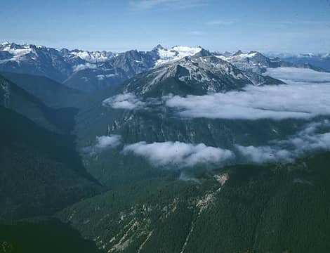
Jack was somewhat clouded over when I was up there a few years ago, but here is a shot...
Jack Mtn (Behind Clouds) And Crater Mtn (Right) From Ruby Mtn
|
| Back to top |
|
|
lopper
off-route
Joined: 22 Jan 2002
Posts: 845 | TRs | Pics
|
|
lopper
off-route
|
Mon Jan 17, 2005 3:27 pm |
|
|
|
| Back to top |
|
|
mike
Member
Joined: 09 Jul 2004
Posts: 6397 | TRs | Pics
Location: SJIsl |
|
mike
Member
|
Mon Jan 17, 2005 5:07 pm |
|
|
| Quote: | | My camera lens was frozen and wouldn't open up. |
That's why I keep my OM1. Nothing to go wrong, no batteries required.  edit: This TR made think Thankfully they didn't build that tramway up there.
|
| Back to top |
|
|
lopper
off-route
Joined: 22 Jan 2002
Posts: 845 | TRs | Pics
|
|
lopper
off-route
|
Mon Jan 17, 2005 10:36 pm |
|
|
One shot deserves another.
Here is an inverse view. What a great neighborhood.
 Ruby frm Crater
|
| Back to top |
|
|
JimK
Member

Joined: 07 Feb 2002
Posts: 5606 | TRs | Pics
Location: Ballard |
|
JimK
Member
|
Mon Jan 17, 2005 11:24 pm |
|
|
Nice shot Lopper. In fact, it's so nice, lets take a closer look at it from the summit of Ruby Mt.
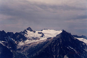 Snowfield Peak From Ruby Mountain
|
| Back to top |
|
|
polarbear
Member

Joined: 16 Dec 2001
Posts: 3680 | TRs | Pics
Location: Snow Lake hide-away |
Mike, what trail would you take to access Sonny Boy Peak? Would it be Kindy Creek or the South Fork Cascade River trail?
|
| Back to top |
|
|
Mike Collins
Member
Joined: 18 Dec 2001
Posts: 3096 | TRs | Pics
|
Fourteen miles past Marblemount take the south side Cascade Road and then the Sonny Boy spur to its end at Kindy Creek. Ford Kindy and on the other side is a forgotten Kindy Creek trail. Follow it a short ways and then follow the fall line to jump onto the Kindy Creek/Sonny Boy divide. Keep walking on the spine of the divide enjoying the views the whole way.
|
| Back to top |
|
|
polarbear
Member
Joined: 16 Dec 2001
Posts: 3680 | TRs | Pics
Location: Snow Lake hide-away |
Thanks Mike, I've eyeballed that mountain on my Pargetter map more than once. Any idea where the name Sonny Boy came from?
|
| Back to top |
|
|
Mike Collins
Member
Joined: 18 Dec 2001
Posts: 3096 | TRs | Pics
|
I only know of the term as an older epithet of endearment popularized by a song of the same name by Al Jolson in the '20s. One verse in the song went like this, "I don't mind those gray skies you made 'em blue Sonny Boy." The early climbers might have tagged the name from that genesis. The name Ruby by the way comes from the garnets in the schist which the early prospectors mistakenly called rubies.
|
| Back to top |
|
|
|
|


