| Previous :: Next Topic |
| Author |
Message |
boot up
Old Not Bold Hiker


Joined: 12 Dec 2006
Posts: 4745 | TRs | Pics
Location: Bend Oregon |
|
boot up
Old Not Bold Hiker
|
 Sun Feb 11, 2018 10:40 pm |
|
|
Wondering why I moved to Central Oregon?
I just couldn't find hikes this Epic and Intense in WA.  I join the CONC (Central Oregon Nordic Club) for a Sunday Social hike fairly often. They pulled out all the stops for today's Epic Hike. Do keep in mind I am one of the youngest people in the club, at age 65.
Weather conditions pushed us out to The Badlands. Where many miles of trails wander through the desert to amazing rock formations. I haven't done the designated Dry Canyon Trail, and didn't know what to expect. Normally the hike in that area is Dry Canyon, which sounds pretty similar but is closed for Raptor breeding from February 1 through September. Apparently raptors have a very long dating period as part of their breeding, or something.
11 people and 5 dogs headed off into the Badlands with enough gear for a day or two hike. The 9 pound Chi-mix quickly established itself as Alpha over the pack of unleashed big dogs. That was definitely entertaining.
I join the CONC (Central Oregon Nordic Club) for a Sunday Social hike fairly often. They pulled out all the stops for today's Epic Hike. Do keep in mind I am one of the youngest people in the club, at age 65.
Weather conditions pushed us out to The Badlands. Where many miles of trails wander through the desert to amazing rock formations. I haven't done the designated Dry Canyon Trail, and didn't know what to expect. Normally the hike in that area is Dry Canyon, which sounds pretty similar but is closed for Raptor breeding from February 1 through September. Apparently raptors have a very long dating period as part of their breeding, or something.
11 people and 5 dogs headed off into the Badlands with enough gear for a day or two hike. The 9 pound Chi-mix quickly established itself as Alpha over the pack of unleashed big dogs. That was definitely entertaining.
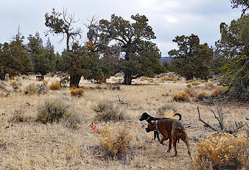 Tough Chi-mix-pound-puppy leading the pack.
Canyon River Trail, East of Bend OR, 2/11/18 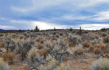 not a lot of landmarks to keep you oriented.
Canyon River Trail, East of Bend OR, 2/11/18 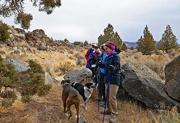 Canyon River Trail, East of Bend OR, 2/11/18 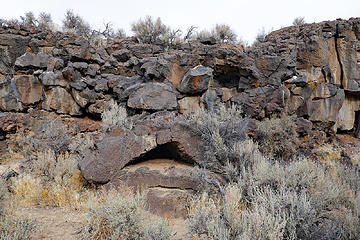 Canyon River Trail, East of Bend OR, 2/11/18 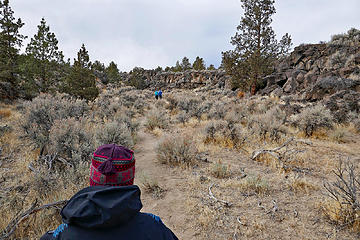 Canyon River Trail, East of Bend OR, 2/11/18 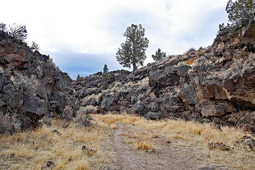 Canyon River Trail, East of Bend OR, 2/11/18 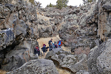 Canyon River Trail, East of Bend OR, 2/11/18 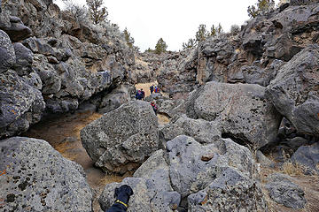 Canyon River Trail, East of Bend OR, 2/11/18 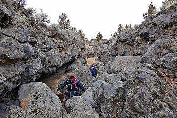 CONC scrambling the rocky section.
Canyon River Trail, East of Bend OR, 2/11/18 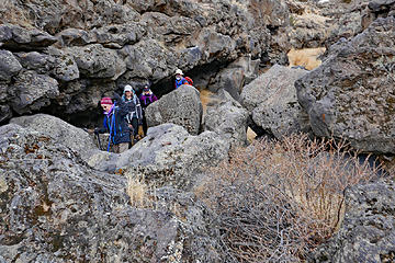 CONC on the rocks.
Canyon River Trail, East of Bend OR, 2/11/18 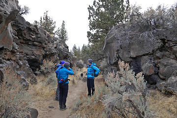 Rest break required on this tough hike.
Canyon River Trail, East of Bend OR, 2/11/18 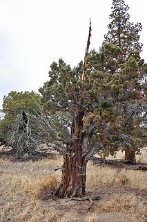 Badlands Gnome
Canyon River Trail, East of Bend OR, 2/11/18 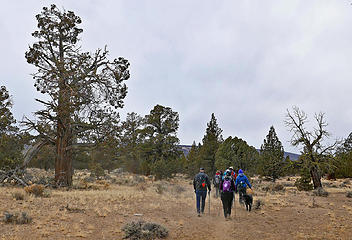 In a cloud of dust, the CONC with a pack of their dogs.
Canyon River Trail, East of Bend OR, 2/11/18 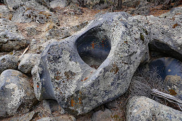 River sculpted rock in an ancient dry riverbed.
Canyon River Trail, East of Bend OR, 2/11/18  We did get a couple of snow flakes falling down during the hike. We did get a couple of snow flakes falling down during the hike.
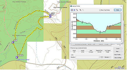 2.2 miles round trip,
63 feet elevation gain
3593 feet elevation parking,
Canyon River Trail, East of Bend OR, 2/11/18 
|
| Back to top |
  
|
|
Just_Some_Hiker
Member

Joined: 02 Jan 2013
Posts: 691 | TRs | Pics
Location: Snoqualmie, WA |
Central/Eastern Oregon's desert is more interesting than Washington's IMO. The terrain is a little more varied and there seems to be more canyons and cool rock formations. I may take a trip down there soon if the terrible snow conditions persist.
As an aside, do you know if the Pole Creek trailhead is accessible right now?
|
| Back to top |
|
|
MyFootHurts
Huge Member

Joined: 22 Nov 2011
Posts: 912 | TRs | Pics
Location: Kekistan |
There's supposed to be petroglyphs in that canyon but I couldn't find them when I did that hike in 2014.
|
| Back to top |
|
|
boot up
Old Not Bold Hiker
Joined: 12 Dec 2006
Posts: 4745 | TRs | Pics
Location: Bend Oregon |
|
boot up
Old Not Bold Hiker
|
Mon Feb 12, 2018 11:50 am |
|
|
| Just_Some_Hiker wrote: | | As an aside, do you know if the Pole Creek trailhead is accessible right now? |
My pet peeve for Oregon, although many might consider it a feature.
There are pretty much no current trip reports or conditions reports available for most trails, and even more so for Central Oregon. You pretty much have to roll the dice and try to get there. Finding information is like stepping back in time. Internet seems to be a new thing that hasn't been incorporated. That is why you have to find some old timers that know where trails are and what conditions might be. Unfortunately the old timers are dying out, so most of the trail usage is concentrated on a very limited number of high visibility trails. It's interesting to compare WA and OR on information distribution and its impact on trail usage.
I can't even find the elevation for that trailhead listed anywhere to give a better idea for snowline. That road might have been affected by last year's forest fires too, or still recovering from the 2013 fires, which damaged the road extensively. A search online finds the most recent trip report from 2013. That is typical or even on the good side of updates in for Central OR.
"Best" information says the trailhead opens generically in June.
|
| Back to top |
|
|
boot up
Old Not Bold Hiker
Joined: 12 Dec 2006
Posts: 4745 | TRs | Pics
Location: Bend Oregon |
|
boot up
Old Not Bold Hiker
|
Mon Feb 12, 2018 11:55 am |
|
|
| MyFootHurts wrote: | | There's supposed to be petroglyphs in that canyon but I couldn't find them when I did that hike in 2014. |
This is where hiking with an experienced group is handy, to find out the history.
There were lots of petroglyphs in this canyon. Sadly, Younguns from a generation or more ago used this area for heavy 4-wheeling and partying and built fires in all the caves and overhangs that had the ancient markings, and they are ALL gone. It really looks like it was purposeful vandalism. Just goes to show that vandalism is not a new thing or just restricted to city slickers.
The trail shooting off the main trail to get to the canyon is not marked and I could have easily shot by without someone showing me the way. There are also large boulders at the front of the canyon to keep 4-wheelers from driving into it.
The Good Ole Days were not all good....
|
| Back to top |
|
|
Just_Some_Hiker
Member
Joined: 02 Jan 2013
Posts: 691 | TRs | Pics
Location: Snoqualmie, WA |
| boot up wrote: | | My pet peeve for Oregon, although many might consider it a feature. There are pretty much no current trip reports or conditions reports available for most trails, and even more so for Central Oregon. |
Yep! That's why I was hoping you might know. The trip report section of the Oregon Hikers forum is dead. Which is amazing since there are so many backcountry users down there.
|
| Back to top |
|
|
boot up
Old Not Bold Hiker
Joined: 12 Dec 2006
Posts: 4745 | TRs | Pics
Location: Bend Oregon |
|
boot up
Old Not Bold Hiker
|
Mon Feb 12, 2018 12:56 pm |
|
|
| Just_Some_Hiker wrote: | | Yep! That's why I was hoping you might know. The trip report section of the Oregon Hikers forum is dead. Which is amazing since there are so many backcountry users down there. |
I keep thinking I must be missing something with the lack of internet information in Central Oregon. The Best information is from the mtn biking sites which sometimes overlap hiking trails or are close enough to be similar. The CONC hiking club site looks like it was designed in the 1990's and you can only access the few posted pics from previous hikes from the club email that is sent out after hikes, and just for that week. And even that info is heavily filtered and audited so that no information is included, such as maps or trip data. They are even hesitant to post people photos without consent from each person, but they won't post pics that don't include club members.  My joke is that some of the club must be in Witness Protection programs.
And they are the best club in the area. Otherwise you have to rely on Meetup groups, and those are the usual sketchy conglomeration of people.
But back to Pole creek trailhead. It appears to be at 5300 feet on a sketchy Forest road. I am not familiar with that road or trailhead, although I will be checking it out in the future, now.
That is an elevation right on the snowline of the moment. A lot depends on how shaded and the exposure of the access road. Likely the trail would be ice/snow right from the parking lot, IF the road is open at all. I was just tromping around on snow/ice at Swampy sno-park at elevation 5822 last week with bare pavement driving in, albeit the road gets sort of plowed. We just had a tiny blast of snow coming through with a few more flurries predicted over the week. Pole Creek is likely to be seeing more snow than down in the lowlands, depending also on how much weather shadow it is getting from Sisters mountains.
It would not be crowded if you can get in there though. My joke is that some of the club must be in Witness Protection programs.
And they are the best club in the area. Otherwise you have to rely on Meetup groups, and those are the usual sketchy conglomeration of people.
But back to Pole creek trailhead. It appears to be at 5300 feet on a sketchy Forest road. I am not familiar with that road or trailhead, although I will be checking it out in the future, now.
That is an elevation right on the snowline of the moment. A lot depends on how shaded and the exposure of the access road. Likely the trail would be ice/snow right from the parking lot, IF the road is open at all. I was just tromping around on snow/ice at Swampy sno-park at elevation 5822 last week with bare pavement driving in, albeit the road gets sort of plowed. We just had a tiny blast of snow coming through with a few more flurries predicted over the week. Pole Creek is likely to be seeing more snow than down in the lowlands, depending also on how much weather shadow it is getting from Sisters mountains.
It would not be crowded if you can get in there though.  Unless it is a snowmobile area. Unless it is a snowmobile area.
|
| Back to top |
|
|
|
|
You cannot post new topics in this forum
You cannot reply to topics in this forum
You cannot edit your posts in this forum
You cannot delete your posts in this forum
You cannot vote in polls in this forum
|
Disclosure: As an Amazon Associate NWHikers.net earns from qualifying purchases when you use our link(s). |


