| Previous :: Next Topic |
| Author |
Message |
ranger rock
One of the boys


Joined: 14 Dec 2011
Posts: 2550 | TRs | Pics
|
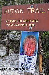 Carol  could be anything 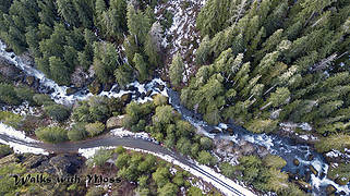 Parking  The old road  SAR ribbon  snow and debris slide on old road  Our lunch spot  Untitled-2 copy
|
| Back to top |
  
|
|
moonspots
Happy Curmudgeon

Joined: 03 Feb 2007
Posts: 2456 | TRs | Pics
Location: North Dakota |
|
moonspots
Happy Curmudgeon
|
 Mon Feb 12, 2018 6:57 am |
|
|
| ranger rock wrote: | | I'm bothered by her disappearance and just had to go check out an intuition I had about where she went... |
Well, I'm glad you went to the trouble of following up on your intuition. Thank you for that, it would have been so easy to "just skip it". I don't know anything about this missing person, but it's good to know that you care enough to make the effort.

"Out, OUT you demons of Stupidity"! - St Dogbert, patron Saint of Technology
"Out, OUT you demons of Stupidity"! - St Dogbert, patron Saint of Technology
|
| Back to top |
|
|
Sculpin
Member

Joined: 23 Apr 2015
Posts: 1383 | TRs | Pics
|
|
Sculpin
Member
|
Mon Feb 12, 2018 9:20 am |
|
|
I think your intuition about the road is a good one. I bet she did. That road actually is one of the recommended routes up Bretherton but I suspect it is used less now because of brush. The washout has been there at least 20 years. I have never actually been to the washout myself, I just bypass it by going straight up the slope from the trail where it gets close to the road, maybe a half mile from the trailhead. It is steep and moderately brushy but no more than 200 yards, the last bit up the road berm required a little bit of fingernail usage.
The reason a person Carol's age would go up that road is to access the White Bridge bootpath (guessing she was not climbing Bretherton). As a long time Olympics hiker, she would no doubt have known about that route. I have thought about heading up the bootpath to look for her remains, but if she got off route it would be a big area to search. If I do go, it would be in summer!
Between every two pines is a doorway to the new world. - John Muir
Between every two pines is a doorway to the new world. - John Muir
|
| Back to top |
|
|
ranger rock
One of the boys
Joined: 14 Dec 2011
Posts: 2550 | TRs | Pics
|
| Sculpin wrote: | | I think your intuition about the road is a good one. I bet she did. That road actually is one of the recommended routes up Bretherton but I suspect it is used less now because of brush. The washout has been there at least 20 years. I have never actually been to the washout myself, I just bypass it by going straight up the slope from the trail where it gets close to the road, maybe a half mile from the trailhead. It is steep and moderately brushy but no more than 200 yards, the last bit up the road berm required a little bit of fingernail usage.
The reason a person Carol's age would go up that road is to access the White Bridge bootpath (guessing she was not climbing Bretherton). As a long time Olympics hiker, she would no doubt have known about that route. I have thought about heading up the bootpath to look for her remains, but if she got off route it would be a big area to search. If I do go, it would be in summer! |
Yep I knew that someone Carol's age would know about that road.
I'd like to know where the boot path was. I want to try it out someday.
I suspect that the climber took the same route that you described thus bypassing the nasty ravine.
 white bridge bootpath? 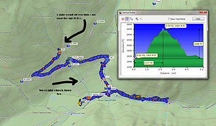 our route and a future plan
|
| Back to top |
|
|
ranger rock
One of the boys
Joined: 14 Dec 2011
Posts: 2550 | TRs | Pics
|
| Sculpin wrote: | | he reason a person Carol's age would go up that road is to access the White Bridge bootpath (guessing she was not climbing Bretherton). As a long time Olympics hiker, she would no doubt have known about that route. I have thought about heading up the bootpath to look for her remains, but if she got off route it would be a big area to search. If I do go, it would be in summer! |
Is this it?
Boulder Creek approach:
This is a difficult route that requires good routefinding skills. Start on the Putvin Trail and hike up to the first of three large washouts. About 100 ft. before the washout climb straight up the mountainside to an abandoned logging road. Try to stay in the large old growth trees, where the terrain is slightly easier. Once you reach the logging road, follow it up the Boulder Creek valley. The road is overgrown with small trees, but there is a faint track down the middle. Immediately after you cross a wooden road bridge, turn left onto a way trail heading west. The trail climbs steeply and is sometimes marked with blazes and ribbons. After a while the tread disappears.Continue to climb up the valley, keeping well above the creek. After a while, you reach a gully. If the sides are too steep to descend, hike down until it is safe to cross. After this point stay as high as possible, crossing a few small boulder fields. Try to find the best route up the headwall cliffs. The cliffs are very brushy with loose timber. The lower of the two Stone Ponds is just above the headwall.
|
| Back to top |
|
|
IanB
Vegetable Belayer

Joined: 21 Jul 2010
Posts: 1062 | TRs | Pics
Location: gone whuljin' |
|
IanB
Vegetable Belayer
|
Mon Feb 12, 2018 8:14 pm |
|
|
| ranger rock wrote: | | Boulder Creek approach:
This is a difficult route that requires good routefinding skills. Start on the Putvin Trail and hike up to the first of three large washouts. About 100 ft. before the washout climb straight up the mountainside to an abandoned logging road. Try to stay in the large old growth trees, where the terrain is slightly easier. Once you reach the logging road, follow it up the Boulder Creek valley. The road is overgrown with small trees, but there is a faint track down the middle. Immediately after you cross a wooden road bridge, turn left onto a way trail heading west. The trail climbs steeply and is sometimes marked with blazes and ribbons. After a while the tread disappears.Continue to climb up the valley, keeping well above the creek. After a while, you reach a gully. If the sides are too steep to descend, hike down until it is safe to cross. After this point stay as high as possible, crossing a few small boulder fields. Try to find the best route up the headwall cliffs. The cliffs are very brushy with loose timber. The lower of the two Stone Ponds is just above the headwall. |
Tried doing this once as an alternate approach to Mt. Stone. The OMCG 4th says to ascend the washout itself to the old road. My buddy and I assumed the road would be obvious and weren't watching our altimeter, so we blew past it and ended up at a pair of little lakes at 4,500' that are probably only visited by hunters. Pretty spot with a sweet view of Pershing.
"Forget gaining a little knowledge about a lot and strive to learn a lot about a little." - Harvey Manning
"Forget gaining a little knowledge about a lot and strive to learn a lot about a little." - Harvey Manning
|
| Back to top |
|
|
Sculpin
Member
Joined: 23 Apr 2015
Posts: 1383 | TRs | Pics
|
|
Sculpin
Member
|
Mon Feb 12, 2018 10:11 pm |
|
|
If you search on "white bridge" in TRs you will find my description appended to a Granola Girl TR.
| ranger rock wrote: | | This is a difficult route that requires good routefinding skills. |
Not really difficult.
| ranger rock wrote: | | Start on the Putvin Trail and hike up to the first of three large washouts. |
A little confused by this.
| ranger rock wrote: | | About 100 ft. before the washout climb straight up the mountainside to an abandoned logging road. Try to stay in the large old growth trees, where the terrain is slightly easier. Once you reach the logging road, follow it up the Boulder Creek valley. |
Yep.
| ranger rock wrote: | | The road is overgrown with small trees, but there is a faint track down the middle. Immediately after you cross a wooden road bridge, turn left onto a way trail heading west. The trail climbs steeply and is sometimes marked with blazes and ribbons. |
More or less correct. The wooden bridge was painted white but is now very deteriorated. The way trail to the left (west) is closing in with alders but folks have kept it open. Don't remember many blazes or ribbons beyond that.
| ranger rock wrote: | | After a while the tread disappears. |
No it doesn't. It is relatively easy to follow up, a little more challenging to follow down due to view angle.
[quote="ranger rock"]Continue to climb up the valley, keeping well above the creek. After a while, you reach a gully. If the sides are too steep to descend, hike down until it is safe to cross. After this point stay as high as possible, crossing a few small boulder fields. Try to find the best route up the headwall cliffs. The cliffs are very brushy with loose timber. The lower of the two Stone Ponds is just above the headwall.
This makes it sound difficult at the top. Sounds like this person lost the tread and ended up in a gully. It is not this hard. Follow the tread until it braids near the top. You are close to Stone Ponds. The various braids lead to 20-30 feet of easy class 3 any way you go. Then poke around for a Class 2 descent.
Between every two pines is a doorway to the new world. - John Muir
Between every two pines is a doorway to the new world. - John Muir
|
| Back to top |
|
|
ranger rock
One of the boys
Joined: 14 Dec 2011
Posts: 2550 | TRs | Pics
|
I don't do class three.. 
|
| Back to top |
|
|
Gregory
Member

Joined: 08 Mar 2014
Posts: 386 | TRs | Pics
|
|
Gregory
Member
|
Wed Feb 14, 2018 6:41 am |
|
|
The question is whether Mrs. Ferguson did class three. Personally, I think she went up there to say goodbye.I think she chose between dementia on the streets of Bummerton or her favorite place.I deeply respect that.
|
| Back to top |
|
|
Sculpin
Member
Joined: 23 Apr 2015
Posts: 1383 | TRs | Pics
|
|
Sculpin
Member
|
Wed Feb 14, 2018 1:48 pm |
|
|
| ranger rock wrote: | | I don't do class three.. |
I call it Class 3 if you have to use your hands. This particular Class 3 is the easiest it gets, no exposure and pretty much zero risk of falling if you have functional hands. The route reaches subalpine parkland and climbs a rib that blocks the route to Stone Ponds. Just before the rib, the route braids to three or so spots where you can get up on the rib, but all of them require a very brief use of the hands. Then once you are up on the rib, you have to pick your way down, but again very easy on meadow ramps. If you have been up the Putvin Trail to Lake of the Angels, you made it past a slightly more challenging spot where you have to grab a big root for about 10 feet with lots of exposure.
Between every two pines is a doorway to the new world. - John Muir
Between every two pines is a doorway to the new world. - John Muir
|
| Back to top |
|
|
ranger rock
One of the boys
Joined: 14 Dec 2011
Posts: 2550 | TRs | Pics
|
| Gregory wrote: | | The question is whether Mrs. Ferguson did class three. Personally, I think she went up there to say goodbye.I think she chose between dementia on the streets of Bummerton or her favorite place.I deeply respect that. |
That thought has passed my mind too. I can think of no better place to die. My Grandma died senile in a nursing home in Bremerton.
|
| Back to top |
|
|
Malachai Constant
Member

Joined: 13 Jan 2002
Posts: 16092 | TRs | Pics
Location: Back Again Like A Bad Penny |
Better to burn out than to Rust
"You do not laugh when you look at the mountains, or when you look at the sea." Lafcadio Hearn
"You do not laugh when you look at the mountains, or when you look at the sea." Lafcadio Hearn
|
| Back to top |
|
|
Pyrites
Member
Joined: 16 Sep 2014
Posts: 1884 | TRs | Pics
Location: South Sound |
|
Pyrites
Member
|
Wed Feb 14, 2018 11:14 pm |
|
|
Anecdotal, not quantitative. But notes really are common. Theyre not just a TV thing.
Keep Calm and Carry On?
Heck No.
Stay Excited and Get Outside!
Keep Calm and Carry On?
Heck No.
Stay Excited and Get Outside!
|
| Back to top |
|
|
treeswarper
Alleged Sockpuppet!
Joined: 25 Dec 2006
Posts: 11277 | TRs | Pics
Location: Don't move here |
|
treeswarper
Alleged Sockpuppet!
|
Thu Feb 15, 2018 10:12 am |
|
|
Snowshoes can be your friend walking on such road conditions. You can keep them on for short stretches of bare ground between snowy parts too.
What's especially fun about sock puppets is that you can make each one unique and individual, so that they each have special characters. And they don't have to be humananimals and aliens are great possibilities
What's especially fun about sock puppets is that you can make each one unique and individual, so that they each have special characters. And they don't have to be humananimals and aliens are great possibilities
|
| Back to top |
|
|
|
|


