| Previous :: Next Topic |
| Author |
Message |
Matt
Tea, Earl Grey, Hot


Joined: 30 Jan 2007
Posts: 4307 | TRs | Pics
Location: Shoreline |
|
Matt
Tea, Earl Grey, Hot
|
 Fri Feb 23, 2018 1:14 am |
|
|
Date: February 19, 2018
Destination: Hamilton Mtn 5093 (USGS Mt. Townsend)
People: Matt, Carla, Elle, Steph
Dogs: Isabel
What I learned from this trip: "Rhododendron" is the Olympics word for "Brush."
At first it was sort of interesting seeing all the wild rhododendrons growing under the forest canopy. It's definitely a different kind of vegetation on the west side of the Olympics. Then we hit places where we had to walk through them. Their twisty stems are tailor made for wrapping around your ankles and knees and waist until you have to push them aside one branch at a time. They don't grow very thickly, so they're not as bad as slide alder or vine maple, but they also grow everywhere, even right up on top of the ridge line.
The other thing I learned is that walking on hard frozen steep ground is really hard on your ankles, knees, legs, back, shoulders, neck etc.
So it was a harder, longer day than we expected. We got a good workout, but were rather sore and tired afterward.
Anyway, we made our way to the summit of Hamilton, which had limited but impressive views of the area around Mt. Constance. Stefan had done this trip in 2012, when they were able to drive up to 3240 feet. Fresh snow low on the road started us lower down, which added extra time to the trip. Once we were higher up, we followed the ridge line, which has a lot of small ups and downs. There are a few steep rock outcrops, but they can be bypassed, pretty much always on the climber's left side.
We picked this trip in order to avoid heavy snowfall and avalanche danger in the Cascades. That part succeeded, since there were only a few inches of fresh snow in the area. As Carla said, "we took our snowshoes out for a walk," since we carried them most of the way, but didn't need them. We did have to use crampons to keep our footing on some of the steeper upper areas.
Round Trip: 10.5 miles, 4060 cumulative gain, 9:45 hours
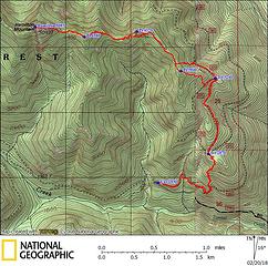 Hamilton GPS track  Cutting uphill between the lower and upper roads 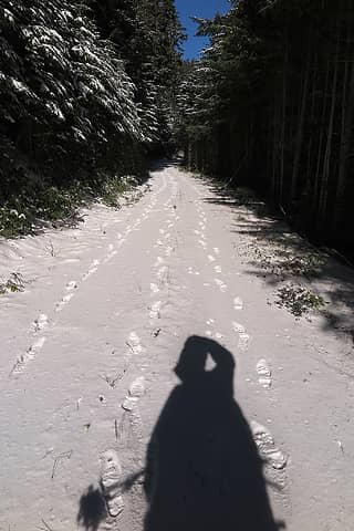 Tracks on the upper road 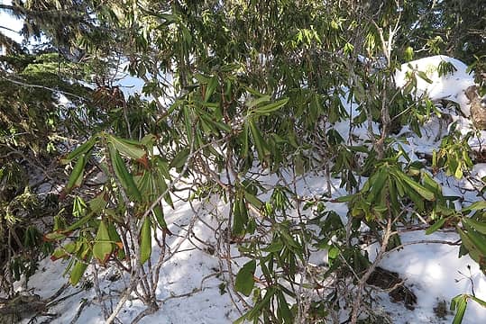 Rhododendrons being brushy 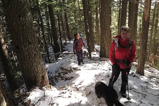 Following the ridge crest 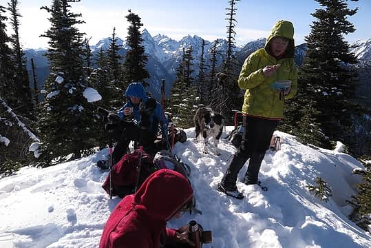 Hamilton summit 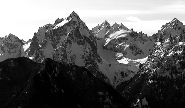 Constance 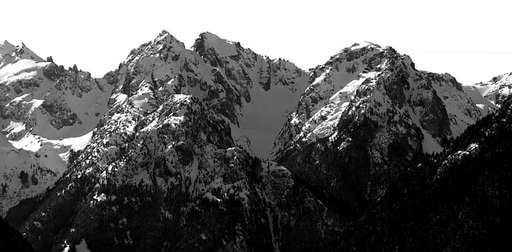 Warrior 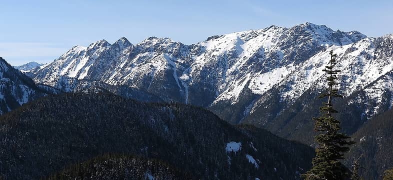 Marmot Pass, Buckhorn, Iron, Worthington, Tull Pass 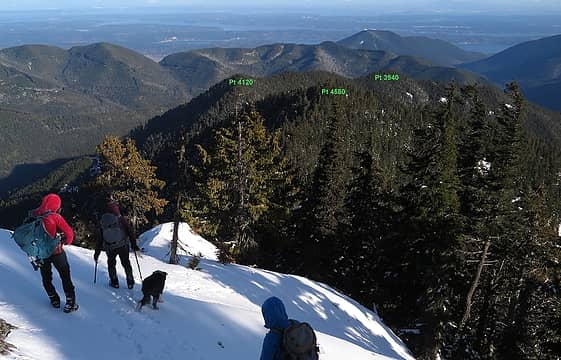 View back down to the ridge we followed 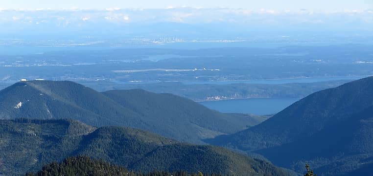 Puget Sound and Seattle 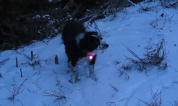 Izzy wearing her night light
As beacons mountains burned at evening. J.R.R. Tolkien
As beacons mountains burned at evening. J.R.R. Tolkien
|
| Back to top |
  
|
|
iron
Member

Joined: 10 Aug 2008
Posts: 6392 | TRs | Pics
Location: southeast kootenays |
|
iron
Member
|
Fri Feb 23, 2018 6:39 am |
|
|
| Matt wrote: | | "we took our snowshoes out for a walk," |
© hollywood 
|
| Back to top |
|
|
Stefan
Member

Joined: 17 Dec 2001
Posts: 5091 | TRs | Pics
|
|
Stefan
Member
|
Fri Feb 23, 2018 11:35 am |
|
|
I like your Black and whites. Nice
|
| Back to top |
|
|
wildernessed
viewbagger

Joined: 31 Oct 2004
Posts: 9275 | TRs | Pics
Location: Wenatchee |

Living in the Anthropocene
Living in the Anthropocene
|
| Back to top |
|
|
puzzlr
Mid Fork Rocks

Joined: 13 Feb 2007
Posts: 7220 | TRs | Pics
Location: Stuck in the middle |
|
puzzlr
Mid Fork Rocks
|
Fri Feb 23, 2018 9:02 pm |
|
|
I appreciate your carefully captioned and labeled photos. Thanks! I can see this peak from my house so I should probably climb it some day.
| Matt wrote: | Puget Sound and Seattle |
So much water!
|
| Back to top |
|
|
reststep
Member

Joined: 17 Dec 2001
Posts: 4757 | TRs | Pics
|
|
reststep
Member
|
Fri Feb 23, 2018 9:29 pm |
|
|
| Matt wrote: | Marmot Pass, Buckhorn, Iron, Worthington, Tull Pass |
What peak is that in the background behind Marmot Pass?
"The mountains are calling and I must go." - John Muir
"The mountains are calling and I must go." - John Muir
|
| Back to top |
|
|
GaliWalker
Have camera will use

Joined: 10 Dec 2007
Posts: 4929 | TRs | Pics
Location: Pittsburgh |
|
GaliWalker
Have camera will use
|
Sat Feb 24, 2018 6:08 am |
|
|
I like that B&W of Constance.
| Matt wrote: | | "Rhododendron" is the Olympics word for "Brush." ... Then we hit places where we had to walk through them. Their twisty stems are tailor made for wrapping around your ankles and knees and waist until you have to push them aside one branch at a time. They don't grow very thickly ... |
Rhododendrons can be impenetrable. I face them all the time here on the east coast, and going through them can be a real workout.
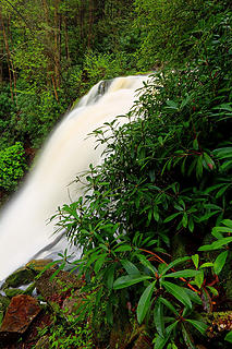 Elakala Falls 3. Blackwater Falls State Park, Monongahela National Forest, West Virginia (May 13, 2017)
|
| Back to top |
|
|
Abert
Member
Joined: 02 Sep 2010
Posts: 588 | TRs | Pics
Location: Sequim |
|
Abert
Member
|
Sat Feb 24, 2018 6:35 am |
|
|
Rhododendrons with just the right covering of snow is even better. Random branches springing up with cold, wet blobs of leaves. In your face, if you're lucky.
That's Martin Peak at the south end of The Needles, reststep.
|
| Back to top |
|
|
Matt
Tea, Earl Grey, Hot
Joined: 30 Jan 2007
Posts: 4307 | TRs | Pics
Location: Shoreline |
|
Matt
Tea, Earl Grey, Hot
|
Sat Feb 24, 2018 11:40 pm |
|
|
Abert, good eye recognizing Martin. I had to zoom in on a photo of the Needles Range from Marmot Pass to see that.
As beacons mountains burned at evening. J.R.R. Tolkien
As beacons mountains burned at evening. J.R.R. Tolkien
|
| Back to top |
|
|
|
|
You cannot post new topics in this forum
You cannot reply to topics in this forum
You cannot edit your posts in this forum
You cannot delete your posts in this forum
You cannot vote in polls in this forum
|
Disclosure: As an Amazon Associate NWHikers.net earns from qualifying purchases when you use our link(s). |


