| Previous :: Next Topic |
| Author |
Message |
Joecreek
Member


Joined: 07 Sep 2006
Posts: 114 | TRs | Pics
|
|
Joecreek
Member
|
 Fri Mar 16, 2018 8:03 pm |
|
|
Haven't seen a recent summer report on the status of the trail. Forest service has the trail listed as abandoned at the pass and not accessible to stock. Is the trail even grossly brushed out and if so, can you get up to the basin below Rennie, or even to the pass? I saw a May report but the guy was snowshoeing and I saw a 2016 report that the trail was invisible. Anyone use it in late 2017?
|
| Back to top |
  
|
|
gray matter
Member

Joined: 28 Oct 2008
Posts: 312 | TRs | Pics
Location: Anacortes |
Joe, I don't have any current beta for you, but I am also interested in the trail conditions. We are planning an early May climb. I will typically throw in a brush saw and do a bit of work on the most significant obstructions. However, from what I've heard, this trail needs a crew for some serious maintenance.
If you go up early this spring, please post a trip report!
Cheers,
Matt
|
| Back to top |
|
|
Joecreek
Member
Joined: 07 Sep 2006
Posts: 114 | TRs | Pics
|
|
Joecreek
Member
|
Tue Jul 31, 2018 1:00 pm |
|
|
Returning to this thread now that the time would be close to make this trip. I'm hoping to take my kid (16) and make a loop. We had the design to go over the pass south of renie. Cross over, fall to the boulder trail, down to the rainbow lake trail, to the lake and around back to McAlester and home. Several days planned.
Are we kidding ourselves about finding trail up to the pass? I know guys have remarked on about the first 3 miles of Reynolds and it sounds annoying with blow down and some "finding" the trail, but doable. Anyone been to the top? I've searched all local landmarks in the forum and no one has posted on this recently. Anyone know someone who may have done a renie summit to respond? Thanks
|
| Back to top |
|
|
gray matter
Member
Joined: 28 Oct 2008
Posts: 312 | TRs | Pics
Location: Anacortes |
Hi Joe,
We went up in May and climbed via the standard south fork route. I can only comment on the first three miles of trail for you. The trail needs a bit of TLC but it was not so bad to negotiate, even for my buddy who had skis on his pack. There were several parties going up and down to ski the north face of Reynolds, but there was plenty of snow at the time. Based on what we were seeing lower down on the trail, I wouldn't count on seeing a well groomed trail to the pass up the north fork. Have you tried calling the ranger district out there?
Good luck,
Matt
|
| Back to top |
|
|
wildernessed
viewbagger

Joined: 31 Oct 2004
Posts: 9275 | TRs | Pics
Location: Wenatchee |
I heard a few years ago that the trail was going to be cleared out then recently that it was going to be abandoned we camped at the basin below the Pass scrambled Rennie looped down to the Pass and back to camp 7/31/2011 and there was a lot of snow in there on that date there is a lot of tree canopy beyond South Reynolds Creek jct.
Living in the Anthropocene
Living in the Anthropocene
|
| Back to top |
|
|
mbravenboer
Member
Joined: 20 Oct 2013
Posts: 1422 | TRs | Pics
Location: Seattle |
Just in case you haven't seen it: keep an eye on the Gilbert fire: "Twisp River Road is CLOSED north of the South Creek Campground". You would be able to access Reynolds still, but you're pretty close to the fire.
|
| Back to top |
|
|
John Morrow
Member

Joined: 03 Apr 2007
Posts: 1526 | TRs | Pics
Location: Roslyn |
Probably close to ten years ago but Randy and donb went all the way to the pass to climb the NW ridge of Renyolds. They didn't mention anything too difficult in the way of trail conditions. Probably find the report here in a search. Or try Cascade Climbers
Tell me, what is it you plan to do with your one wild and precious life?-Mary Oliver
A nation that continues year after year to spend more money on military defense than on programs of social uplift is approaching spiritual doom.
― MLK Jr.
Tell me, what is it you plan to do with your one wild and precious life?-Mary Oliver
A nation that continues year after year to spend more money on military defense than on programs of social uplift is approaching spiritual doom.
― MLK Jr.
|
| Back to top |
|
|
mountainflamingo
Member

Joined: 15 Nov 2008
Posts: 82 | TRs | Pics
Location: Tralfamadore |
I was up there in early June. The trail was definitely a bit brushy and had a good number of downed trees across it. Nothing too difficult though and I generally found it easy to follow. I left the trail at the south fork of the creek to climb Reynolds, which is where the snow started at that time.
https://mountainflamingo.com/2018/06/04/2018-06-02-reynolds-peak/
I also hiked all the way to the pass in Sept. 2010. There were less blow downs than there are now, but I remember the trail being nicer after passing the south fork of the creek than the beginning of the trail....and lots of berries. The meadows at the pass were amazing as well. I think I remember having to cross a scree field without much of a sign of trail in the basin just before you get to the pass, but it was not particularly difficult
https://photos.app.goo.gl/3R9U7qSYgycvALaLA
|
| Back to top |
|
|
mountainflamingo
Member
Joined: 15 Nov 2008
Posts: 82 | TRs | Pics
Location: Tralfamadore |
Well I'm glad I went in there this spring...looks like it might all get burned again any day now.
|
| Back to top |
|
|
Joecreek
Member
Joined: 07 Sep 2006
Posts: 114 | TRs | Pics
|
|
Joecreek
Member
|
Thu Aug 02, 2018 9:29 pm |
|
|
Thanks for the assists all.
Looks to be moot. The gibert fire looks like it may burn reynolds. Rd is closed much farther back to the east now. Also, ranger district says the trail is now only maintained to the wilderness boundary, about a mile? Unless there are rapid changes, i 'll see whats left next year!
|
| Back to top |
|
|
Jake Robinson
Member
Joined: 02 Aug 2016
Posts: 521 | TRs | Pics
|
CalTopo current fires layer shows that Reynolds Creek is burning 
|
| Back to top |
|
|
wildernessed
viewbagger
Joined: 31 Oct 2004
Posts: 9275 | TRs | Pics
Location: Wenatchee |
If the fire gets into the South Fork of War Creek that will send up a plume so much fuel from dead and dying trees more than the other areas.
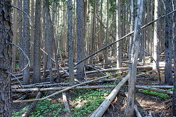 This picture pretty much sums up the terrain of the entire trip.
Living in the Anthropocene
Living in the Anthropocene
|
| Back to top |
|
|
|
|


