| Previous :: Next Topic |
| Author |
Message |
Justus S.
Member


Joined: 17 Nov 2004
Posts: 1298 | TRs | Pics
Location: WA |
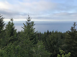
Did a quick hike up Cowboy Mtn this morning.
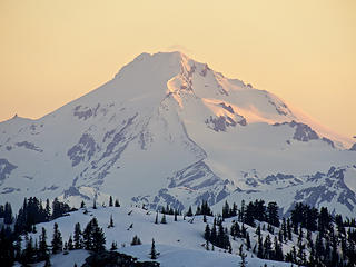 Sunrise on Glacier Peak 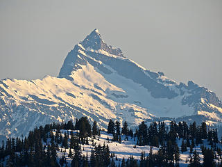 Sloan Peak 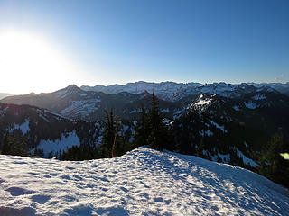 Early morning view toward Chiwaukums 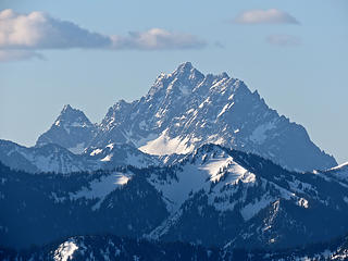 Mount Stuart 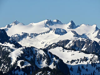 Mount Daniel 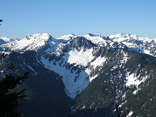 Thor to Mt Daniel 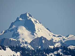 Del Campo 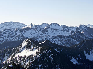 Bulls Tooth 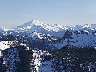 Glacier Peak 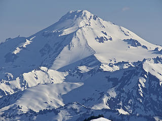 Glacier Peak 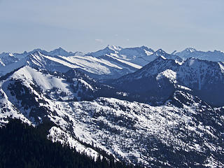 Clark
|
| Back to top |
  
|
|
olderthanIusedtobe
Member
Joined: 05 Sep 2011
Posts: 7709 | TRs | Pics
Location: Shoreline |
That looks spectacular Justus. Wasn't familiar w/ that peak at all. Conveniently located right next to everything?  A bit of zooming in going on I would think. But like I said spectacular. A bit of zooming in going on I would think. But like I said spectacular. 
|
| Back to top |
|
|
olderthanIusedtobe
Member
Joined: 05 Sep 2011
Posts: 7709 | TRs | Pics
Location: Shoreline |
I'm not sure why, but somehow I'd never hiked the East Bank Baker Lake trail in more than 20 years of living in Pugetopolis and hiking frequently. Finally changed that Monday (5/14). Started from the south trailhead. Very much enjoyed it. Had no particular destination in mind. Made it to Silver Creek before turning around and heading back. Will need to start from the north trailhead next time and see the rest of it, but I definitely got more than half. Was tempted to push on to Noisy Creek but it was hot and I didn't want to overdo it. Probably a good decision. Somewhere around Maple Grove on the way back I started to bonk a little bit.
|
| Back to top |
|
|
FungiFan
Member
Joined: 09 Sep 2010
Posts: 395 | TRs | Pics
Location: East of the Olympics |
|
FungiFan
Member
|
 Sun May 20, 2018 7:43 am |
|
|
Frog Farm and I just finished the Beach Naturalist program and figured a quick trip to the Salt Creek Recreation area with a -2.3 tide would be a nice way to celebrate. Did a post-prandial hike up to the top of Striped Mountain for its "Vista" view of the Straits of Juan de Fuca and then back to the now packed campground for sunset.
 Straits of Juan de Fuca from Striped Mountain 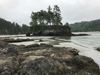 Tidal island at Tongue Point 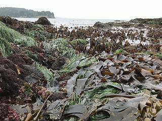 Seaweed forest 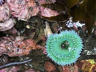 Giant green anemone 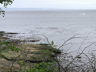 Bull kelp forest, -2.3 tide at Tongue Point
Stupid isn't illegal...but sure comes with consequences.
Famous last words: 'Here, hold my beer and watch this.'
Stupid isn't illegal...but sure comes with consequences.
Famous last words: 'Here, hold my beer and watch this.'
|
| Back to top |
|
|
olderthanIusedtobe
Member
Joined: 05 Sep 2011
Posts: 7709 | TRs | Pics
Location: Shoreline |
I've got a semi-regular hiking buddy that is good at suggesting some hikes I've overlooked. Yesterday we hit Cow Heaven, first time for me. The creek along the lower part of the trail is lovely and charming. I enjoyed the mossy woods, abundant ferns and various other plants. We got about 3.5 miles up the trial, just short of the 4,000' level when patchy snow quickly transitioned to complete coverage. Lost the trail immediately, didn't really feel like kicking steps through the woods without being sure where we were going, so we turned around. Pleasant day out. Skagit and various other rivers look high.
|
| Back to top |
|
|
Token Civilian
Member
Joined: 02 Sep 2010
Posts: 590 | TRs | Pics
|
My Baden Powell, PCT Southern California
Down in so cal on business and decided to visit an old friend I hadnt seen since the thru hike in 2006. Vincent gap trailhead to the summit is 4 miles and 2800 feet of climbing to the 9390 foot summit. Suffice it to say that the grade is consistent and unrelenting. There were a lot of folks huffing and puffing from the altitude. A slow steady pace worked well, putting me on top in a couple of hours.
Temps were mild to chilly on the summit. The LA side was shrouded in cloud cover below the summit but it was clear if a bit hazy from the west to the north and east.
A $5 per day adventure pass is required for the trail head parking. The TH is well developed with lots of parking, but expect it to fill on a nice day like I had.
This makes a great day hike, giving a good sample of the steep, rugged terrain of the San Gabriel Mountains.
|
| Back to top |
|
|
olderthanIusedtobe
Member
Joined: 05 Sep 2011
Posts: 7709 | TRs | Pics
Location: Shoreline |
A bit belated, spent Memorial Day and Tuesday over in the Teanaway. First up was Bean Creek trail to Earl Peak. First creek crossing was a bit tricky, using a log spanning about half of the creek and some barely submerged rocks I was able to keep my feet dry and not have to ford. Later creek crossings were a piece of cake to hop across. Got about halfway up the switchbacks to the saddle on the south side of Earl before hitting any snow. Just a few patches for the most part, maybe last several hundred feet were nearly completely snow covered. Lost the trail but there was a boot path and it was pretty easy to just aim uphill at the blue sky showing up thru the trees. From the saddle it was fairly easy to avoid snow if so desired the rest of the way.
Descended to the west and ran the ridge over to the base of Bean Peak. Patchy snow off and on but quite a bit of bare ground on the crest and almost completely bare on the south facing slope. For some reason didn't really feel like tagging Bean so descended a decent path down into the basin. Glacier lillies are popping, it's a bit early for shooting stars (I saw maybe 2 total). Balsam root are fading but still hanging on. A few other flowers here and there, can't even remember what I saw now.
Chilled in the basin for a while. So peaceful. There was a group of campers nearby, I heard the earlier when I was above them but while I was sitting there it was nothing but bird song and the sound of the creek. Lovely day, sunny but not too warm.
Tuesday headed up to Ingalls Pass. It always seems to be holding more snow than pretty much every other trail out that way, but even then I was surprised to hit some patches almost immediately after the trail junction. From about midway up to the pass it was almost continuous. Followed some boot track for the most part, or just wandered wherever looked best. There was a high cloud layer so visibility was good but no sun. Got to the pass and it was freaking windy and cold! Gazed at Stewie and the Ingalls complex for a while, lost motivation to continue on to the lake, so headed back down and ended the hike before midday. I'd been contemplating driving around to Leavenworth and maybe doing Eightmile Lake but I just headed home instead. Finally heard my first hermit thrush of the year and also first pika of the season. Somehow I didn't make it over to the Teanaway at all last year, was way overdue, always love visiting there.
|
| Back to top |
|
|
olderthanIusedtobe
Member
Joined: 05 Sep 2011
Posts: 7709 | TRs | Pics
Location: Shoreline |
Way overdue for a return to this old favorite. Off trail. A decent path for a while (climbers' approach), then just rock hopping and bushwacking up a river bed. Started out cloudy but cleared up mid afternoon. Had lunch w/ a pair of pikas and both hermit and varied thrush (heard a Swainson's earlier so I got the trifecta of thrushes). 20+ years ago I stumbled on this by accident when I made a wrong turn, yesterday I encountered a couple who did the same thing. I think that's the only time I've encountered another party up here. The path part was in good shape, almost seems like it's been brushed out. People are obviously still going up here but it looks pristine to me. I'm sure some of you will recognize this.
|
| Back to top |
|
|
meck
Member
Joined: 31 Dec 2010
Posts: 920 | TRs | Pics
|
|
meck
Member
|
Thu Jun 14, 2018 8:10 pm |
|
|
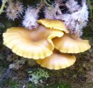
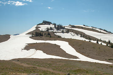
Had an early shift on Tuesday, and was able to sneak in a trip up Mt Townsend that afternoon/evening before the rain came in. The weather was absolutely perfect, too bad the rechargeable batteries in my camera weren't! Got a few pics before the "battery exhausted" message. Briefly I was able to see all five volcanoes (though Rainier was still poking up into the clouds), the evening sun shining on Adams was like a wonderful orange beacon through the gray. It was chilly at the top.
 summit in view  not much snow left up there 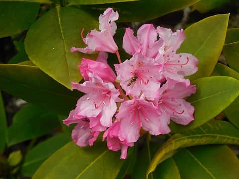 some rhodiess blooming lower 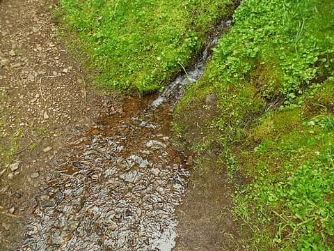 small stream near the beginning, won't last much longer 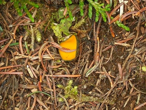 fungi of some sort 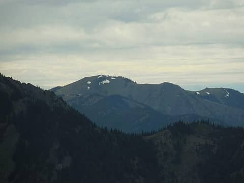 Blue Mtn from the trail (beyond Tyler Peak's shoulder)  I love this sign, my favorite outdoor playground awaits.... 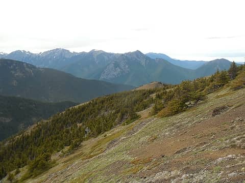 5 labels Graywolf, Baldy, Tyler (& Maynard) peaks 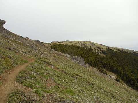 summit in view 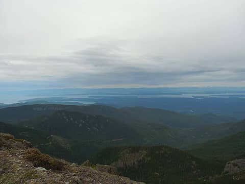 looking NE 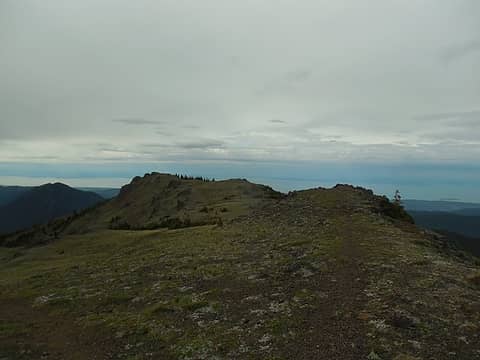 summit ridge north 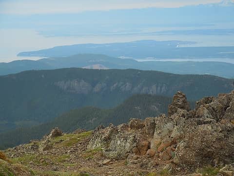 Mt Zion 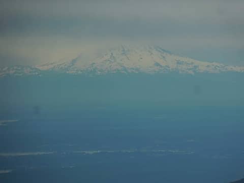 the base of Rainier 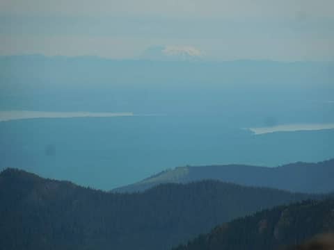 St Helens in the distance.
*Just say NO to Rent-Seeking, don't give up the concept of "ownership"*
*Just say NO to Rent-Seeking, don't give up the concept of "ownership"*
|
| Back to top |
|
|
Ancient Ambler
Member

Joined: 15 May 2007
Posts: 1092 | TRs | Pics
Location: Bainbridge Island |
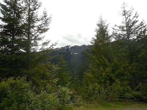
Read that the Obstruction Point road is open all the way to Obstruction Point and headed out there on June 19 with Dave B to roam Lillian Ridge for a few miles. Found about six cars at the parking lot. Still plenty of big patches of snow over the trail, but lots of snow-free trail as well. One patch of snow over the trail where it starts to drop down toward Grand Valley. Snow over portions of the way trail that heads over toward Moose. Lots of snow still on Grand Pass. Elk Mountain and Grand Ridge trail mostly snow-free as far as could be seen from where we were, though there is probably snow across the trail where it crosses the east face of Obstruction Peak. Fine views west to the Bailey Range, with substantial snow still on the east facing slopes over there.
 trail ascending Lillian Ridge from Obstruction Point 06-19-2018 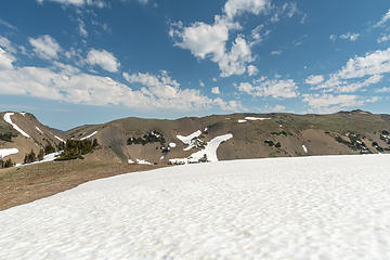 Obstruction Peak to left, Elk Mountain center to right 06-19-2018 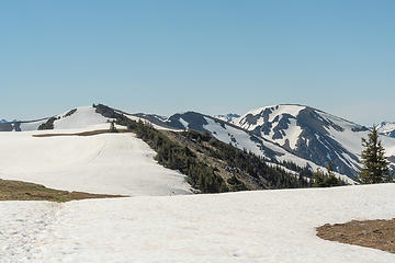 Large patches of snow still on Lillian Ridge 06-19-2018 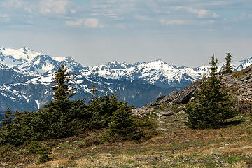 Stephen Peak, center; Olympus to the left; 06-19-2018 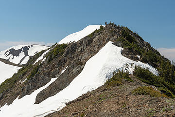 _DSC4624 sj 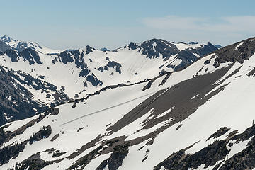 1 label Plenty of snow left on Grand Pass 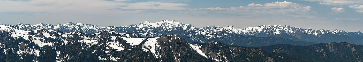 10 labels View west from Lillian Ridge, Olympic National Park 06-19-2018
|
| Back to top |
|
|
RichP
Member

Joined: 13 Jul 2006
Posts: 5634 | TRs | Pics
Location: here |
|
RichP
Member
|
Wed Jun 20, 2018 1:50 pm |
|
|
Thanks for the intel, Ancient Ambler. I'm headed out that way next week.
|
| Back to top |
|
|
bobbi
stillaGUAMish

Joined: 13 Jul 2006
Posts: 8012 | TRs | Pics
Location: olympics! |
|
bobbi
stillaGUAMish
|
Sun Jun 24, 2018 8:14 pm |
|
|
testing out my new boots and obstruction point road in olympic national park is open.
with sweetie Mark
lots of avalanche lilies!
mt. olympus is always so beautiful
lots of snow
camo birds
some wildflowers
that's all!
bobbi ૐ
"Today is your day! Your mountain is waiting. So
get on your way!" - Oh, the Places Youll Go! By Dr. Seuss
bobbi ૐ
"Today is your day! Your mountain is waiting. So
get on your way!" - Oh, the Places Youll Go! By Dr. Seuss
|
| Back to top |
|
|
Rockstarr511
Sandz

Joined: 28 Mar 2011
Posts: 35 | TRs | Pics
Location: King County |
Lake Dorothy from Miller River Road (6/26)
Wanted to see one of the larger alpine lakes and have never made it up there before. Trail was a little muddy but overall in great shape. We hiked along the lake to the south shore and had lunch. For such a large lake, I was surprised by how few spots there were along the lake that provided easy shore access. Wanted to continue on to Bear Lake and Deer Lake but had some time constraints. Saving those for next time!
Miller River Road was in good condition with some larger potholes in the last 2 miles before the trail head. Only ran into a couple other groups and there were only 5 cars at the trail head around noon.
"There is no opiate like alpine pedestrianism."
Mark Twain
"There is no opiate like alpine pedestrianism."
Mark Twain
|
| Back to top |
|
|
Jake Robinson
Member
Joined: 02 Aug 2016
Posts: 521 | TRs | Pics
|
Cathedral/Amphitheater/Remmel via the Andrews Creek Trail Monday-Tuesday. Happy to report that Upper Cathedral Lake was spared by the Diamond Creek Fire (just barely). The destruction from that fire is incredible. The view from Remmel helps you appreciate how vast the destroyed area is. For now, travel through the burn is easy.
|
| Back to top |
|
|
bobbi
stillaGUAMish
Joined: 13 Jul 2006
Posts: 8012 | TRs | Pics
Location: olympics! |
|
bobbi
stillaGUAMish
|
Sun Jul 01, 2018 9:35 pm |
|
|
Klahhane Ridge via Switchback Trail, ONP, July 1, 2018
bobbi ૐ
"Today is your day! Your mountain is waiting. So
get on your way!" - Oh, the Places Youll Go! By Dr. Seuss
bobbi ૐ
"Today is your day! Your mountain is waiting. So
get on your way!" - Oh, the Places Youll Go! By Dr. Seuss
|
| Back to top |
|
|
|
|


