| Previous :: Next Topic |
| Author |
Message |
BeardoMcGrath
Member

Joined: 16 Jan 2018
Posts: 143 | TRs | Pics
Location: Snohomish |
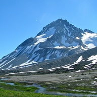
After reading up on some intriguing adventures along the upper Suiattle River (see Upper Suiattle River to Chocolate Creek and Upper Suiattle to Dusty Creek) I decided to make use of the excellent weather last weekend and see how far into the infrequently-traveled NE side of Glacier Peak I could get.
I arrived at the Suiattle River trailhead around Noon on Saturday, after slowly driving along the very potholed Suiattle River Road. I had done two daytrips previously on this trail, but during December and April so this was my first good weather outing in the valley.
I approached the well-reported landslide around 12:45; passing through this is tricky with an overnight pack and requires climbing under fallen trees in some dirt and mud. I saw some WTA trail maintenance gear nearby but clearing this looks like it will be a lot of work. The fallen cedars made for a very fragrant experience though.
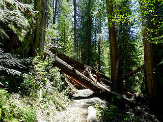 Looking upvalley 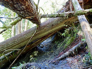 Looking downvalley. The hardest part is squirming under the trees here with a big pack 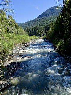 Looking upstream at the PCT Bridge 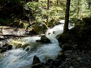 Dolly Creek at high water 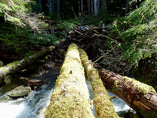 Log crossing 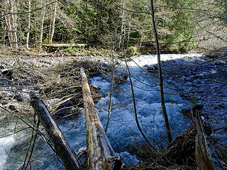 Log crossing, with old bridge behind  Go little cabbage go! 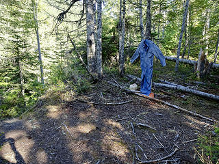 Upper Suiattle Trail descends to left, Gamma Ridge Trail to right 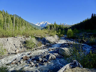 Crossing the creek here would be doable in the morning 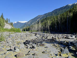 Looking downriver at the old PCT Crossing 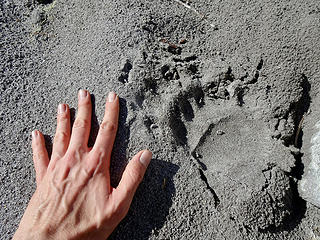 Better watch over my shoulder! 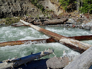 Log crossing of the Suiattle. Might have been problematic if the water were any higher 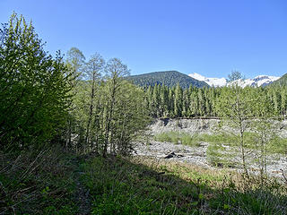 View of Glacier Peak from the other side of the river
|
| Back to top |
  
|
|
JVesquire
Member

Joined: 28 Jun 2006
Posts: 993 | TRs | Pics
Location: Pasco, WA |
Nice TR. That's a great place. Don't underestimate that Dusty Creek crossing. It is cold and fast.
|
| Back to top |
|
|
RichP
Member

Joined: 13 Jul 2006
Posts: 5634 | TRs | Pics
Location: here |
|
RichP
Member
|
 Fri May 18, 2018 6:37 pm |
|
|
Very nice trip. 
|
| Back to top |
|
|
chiwakum
not credible

Joined: 29 Jun 2009
Posts: 980 | TRs | Pics
Location: Ballard |
|
chiwakum
not credible
|
Sat May 19, 2018 6:22 pm |
|
|
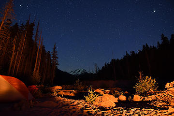
Thanks for the report. I was also rambling on the south side of the river last weekend but turned around at Vista Creek. The view from your camp looks similar to mine from memorial weekend last year. I also ran across that note about fires from last year. I was impressed with how well the paper had weathered the winter.
 img_020
|
| Back to top |
|
|
BeardoMcGrath
Member
Joined: 16 Jan 2018
Posts: 143 | TRs | Pics
Location: Snohomish |
| chiwakum wrote: | | Thanks for the report. I was also rambling on the south side of the river last weekend but turned around at Vista Creek. The view from your camp looks similar to mine from memorial weekend last year. I also ran across that note about fires from last year. I was impressed with how well the paper had weathered the winter. |
I did see a set of footprints as far as Vista Creek...nice night shot!
|
| Back to top |
|
|
chiwakum
not credible
Joined: 29 Jun 2009
Posts: 980 | TRs | Pics
Location: Ballard |
|
chiwakum
not credible
|
Sun May 20, 2018 11:35 am |
|
|
Thanks, I probably should continue to lug my heavy Nikon around (used for that shot). My mirrorless setup can't quite cut it. Shoot, if I had realized that there was a usable log in the area you crossed I would have made the effort to continue past Vista Ck for a loop trip.
Last year there were a zillion bear prints all around my camp along the river (including new ones when I got up both mornings). I didn't notice any this year.
|
| Back to top |
|
|
BeardoMcGrath
Member
Joined: 16 Jan 2018
Posts: 143 | TRs | Pics
Location: Snohomish |
Yes, admittedly it was a bit of a risk to head as far as I did downriver on the SW side; if I hadn't found a log before Gamma Creek I probably would have had to go all the way back or bushwhack up the fill to the trail.
Yeah, I didn't see any bear prints at Dusty Creek, and just the one set heading upriver across from where Miners Creek enters the Suiattle.
|
| Back to top |
|
|
Homey360
Member
Joined: 10 Aug 2016
Posts: 18 | TRs | Pics
Location: Issaquah, WA |
|
Homey360
Member
|
Wed May 23, 2018 8:59 pm |
|
|
Great report. I went around Glacier last season and was tempted to try the old route you describe but played in conservative. Planning to do it again this year and will try the old route this time. Has anyone tried the old route up to Buck Creek Pass that crosses Triad Creek?
"for everyone needs beauty as well as bread, places to play in and pray in where Nature may heal and cheer and give strength to body and soul alike."
"for everyone needs beauty as well as bread, places to play in and pray in where Nature may heal and cheer and give strength to body and soul alike."
|
| Back to top |
|
|
WalkAbout Wally
The Kununurra Kid

Joined: 27 May 2005
Posts: 11 | TRs | Pics
Location: Lost in Seattle |
Awesome Report! Exploring Upper Suiattle on Bucket List for some time...
Thank You for the Inspiration!
|
| Back to top |
|
|
|
|


