| Previous :: Next Topic |
| Author |
Message |
SultanHiker
Member


Joined: 04 Aug 2014
Posts: 78 | TRs | Pics
Location: Washington |
I have been to the Stickney summit the last 3 years. This year i went a little early after a heavy winter snow season. I wanted to dial in a definitive route so I could post a GPS track for future climbers. But there was a lot of snow on the Olney Creek route as soon as I left the old road. So my track this year will likely not be a perfect Beta for a snow free route later in the season. But I think I preferred these conditions. It made the track between the road and One Acre Lake much easier. Creek beds and bushes were easier.
Ice axe and Microspikes/crampons necessary.
I always go the Olney Creek route. Made the decision a few years ago and Im familiar with it. Still might try something from Wallace Falls area in the future. I live in Sultan. Im only 40 and have lots of time to explore, I hope...
I brought my 13 year old son 2 years ago. He made it farther than i thought he would (200 yds short of true summit due to fear of heights). He wanted to make summit this year. Probably a bad idea this early due to the snow pack. But I was overdue for a deep, long, day-long peak-bagging excursion. So off we go!
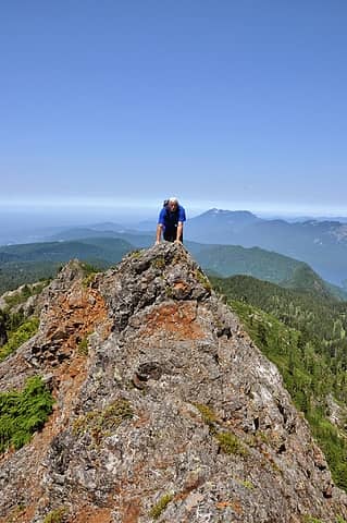
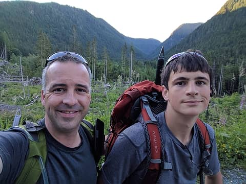 Before the long slog 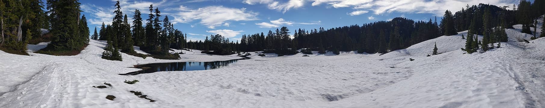 One Acre Lake 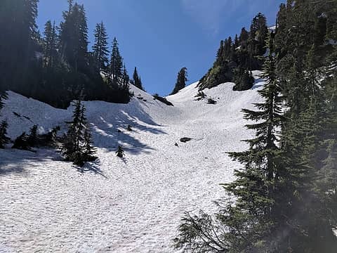 Between the lake and pond 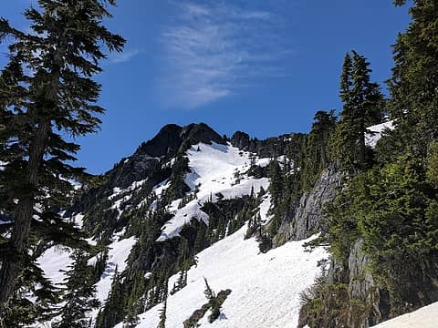 Summit in sight 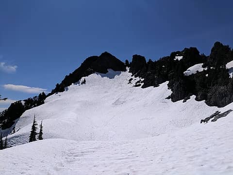 Gully below the summit block 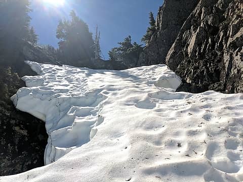 Last bit of snow in the notch before the scramble to summit 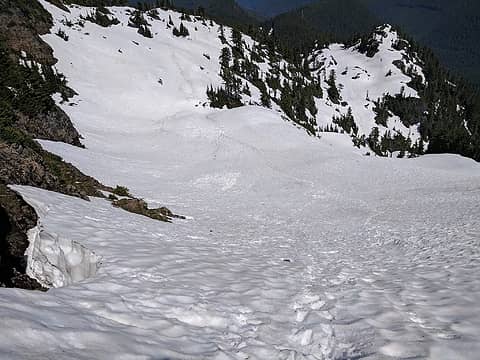 View down the gully 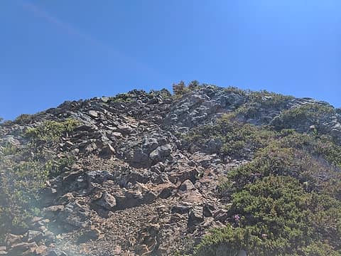 Scramble 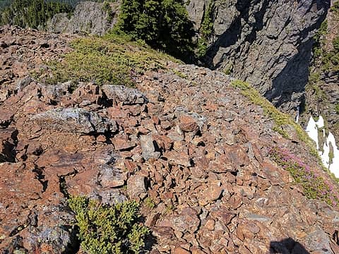 Loose crap 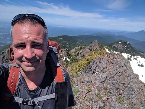 Selfie 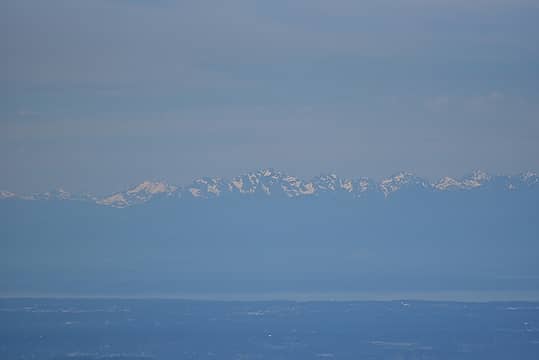 Olympics 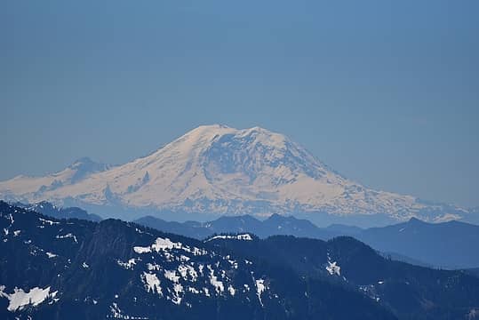 Rainier 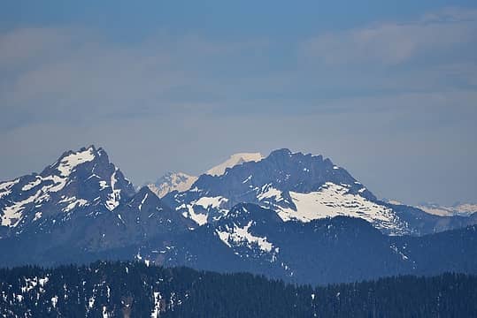 Peekabo Baker 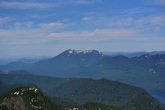 Pilchuck 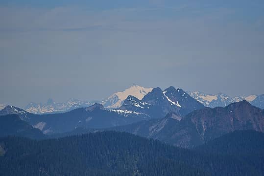 Shuksan 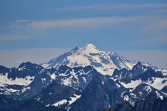 Glacier 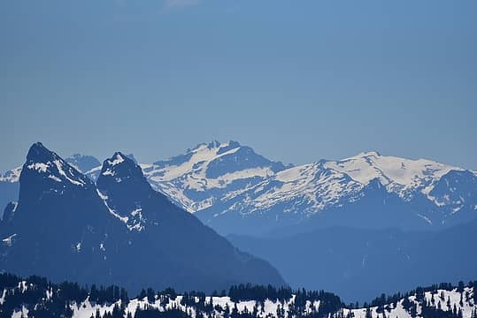 Baring, Daniel, Hinman 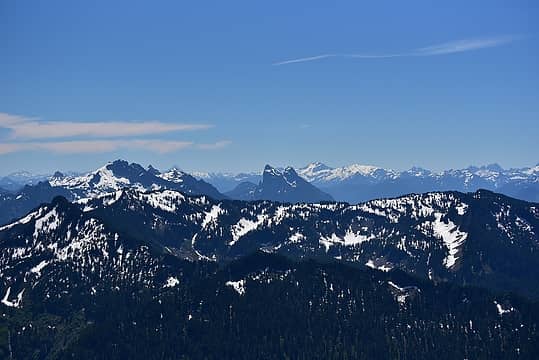 Wider view with Gunn 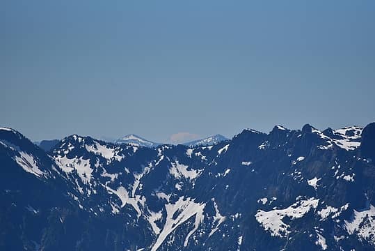 Adams 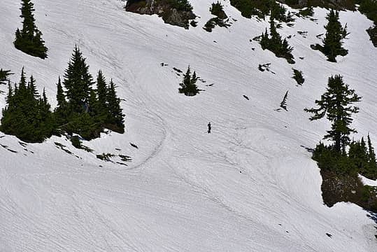 My son waiting for me... 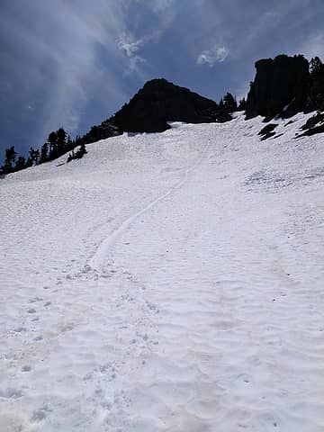 Glissade path
|
| Back to top |
  
|
|
flatsqwerl
Member
Joined: 23 Feb 2010
Posts: 1049 | TRs | Pics
Location: tacoma |
That looks like a great time to do the peak with all that brush covered by snow.
|
| Back to top |
|
|
Steve Erickson
Member

Joined: 13 Jun 2005
Posts: 210 | TRs | Pics
Location: Next door to my neighbors |
You mentioned that you did not purchase gaiters for your son yet. I always carrying duc tape in my truck and when I think I may need gaiters and don't have them, I use duc tape. Works great.
|
| Back to top |
|
|
SultanHiker
Member
Joined: 04 Aug 2014
Posts: 78 | TRs | Pics
Location: Washington |
Steve Erickson:
His legs are hairier than mine!!!
But not a bad tip!
In all seriousness, debris was almost a non-factor. And when asked, he said that he didn't get a lot of snow at the top of his boots.
|
| Back to top |
|
|
Roald
Member

Joined: 06 Aug 2007
Posts: 367 | TRs | Pics
Location: Seattle |
|
Roald
Member
|
 Wed Jun 28, 2017 9:29 pm |
|
|
Thanks for the beta and description of your trip. I drive by Stickney all the time and it is so attractive from Hwy 2. Maybe next year...
|
| Back to top |
|
|
SKS
Member
Joined: 16 Jun 2011
Posts: 161 | TRs | Pics
Location: Snohomish |
|
SKS
Member
|
Thu Jun 29, 2017 10:26 am |
|
|
I know what you're talking about with the long hikes on hot days on snow. I've done a couple this year and can never seem to drink enough water. With the sweat and fatigue my symptoms are usually cramps that last into the night while I'm trying to sleep.
After my last hike, around midnight, I washed down a tablespoon of salt and cramps were gone in less than 10 seconds and didn't return. Hopefully it will work next time, too.
Glad you made it safely.
|
| Back to top |
|
|
KurgansDad
Member
Joined: 03 Apr 2015
Posts: 23 | TRs | Pics
|
Another excellent Father son adventure. My 14 yr old finally said he wants to go camping/hiking with me. I don't think he's ready for Stickney, but maybe the lakes.
Almost a year later from your post, what do you think the conditions would be like there this year?
For too many years I gazed at the Cascades and other mountains as they taunted me and I said "...Someday..." Now I find I'm running out of somedays...
For too many years I gazed at the Cascades and other mountains as they taunted me and I said "...Someday..." Now I find I'm running out of somedays...
|
| Back to top |
|
|
SultanHiker
Member
Joined: 04 Aug 2014
Posts: 78 | TRs | Pics
Location: Washington |
Definitely not for rookie 14 year olds. But after some conditioning, maybe your kid would be up for it. I'm guessing there's still snow. Maybe the road is clear, but the forest and talus slopes will still be covered right now.
|
| Back to top |
|
|
KurgansDad
Member
Joined: 03 Apr 2015
Posts: 23 | TRs | Pics
|
Thanks. Yeah, he needs a lot of conditioning. I don't want to burn him out and have him not enjoy hiking.
Snow in the forest? I would have thought that canopy would pretty much block almost anything. I've been up there in the rain, and barely got wet while in the heaviest parts
For too many years I gazed at the Cascades and other mountains as they taunted me and I said "...Someday..." Now I find I'm running out of somedays...
For too many years I gazed at the Cascades and other mountains as they taunted me and I said "...Someday..." Now I find I'm running out of somedays...
|
| Back to top |
|
|
SultanHiker
Member
Joined: 04 Aug 2014
Posts: 78 | TRs | Pics
Location: Washington |
The road walk has lots of southern exposure and at lower elevation. So it melts out quicker. The forest sees less sun and has higher elevation. The gully below the summit faces north and is the biggest obstacle to gaining the summit. When it melts out, there is a some webbing that aids in climbing the notch. If it is out of reach or not trustworthy, then it borders on Class 4 for a little bit.
I might be climbing it later this year if schedules allow. If you are interested in joining, PM me. (probably September/October as my July/August look pretty busy)
|
| Back to top |
|
|
evergreenhiker
Hiking Specialist

Joined: 13 Nov 2004
Posts: 367 | TRs | Pics
Location: Gold Bar |
| SultanHiker wrote: | | When it melts out, there is a some webbing that aids in climbing the notch. If it is out of reach or not trustworthy, then it borders on Class 4 for a little bit. |
Stickney is on my list too, but never done it. So one might need rope for that section? No experience with rope stuff. Is this the easiest way up to the summit? Class 4 is like climbing a cliff right? i will getting a helmet regardless when I do this.
The alpine world is my church.
The alpine world is my church.
|
| Back to top |
|
|
JustsayMo
Member
Joined: 30 Sep 2013
Posts: 24 | TRs | Pics
Location: PNW |
Thank you for this excellent report.
|
| Back to top |
|
|
SultanHiker
Member
Joined: 04 Aug 2014
Posts: 78 | TRs | Pics
Location: Washington |
It's hard to explain. One year, the hand line made of webbing was out of reach from the notch (it was blown up by wind or some jerk threw it up high) . I was just barely able to free climb up and grab it to make it the rest of the way (and left it low when I was done) . but if you're shorter than me, it would be difficult to make the first couple moves. I'm 5-10, almost. and I'm a pretty decent climber, although I don't do true rock climbing. But I am on ladders and roofs all day at my job. Usually the handline is easily within reach, and gives most everyone (not afraid of heights) the stability and safety to get to a vantage point to gain the ridge. After the notch, there's not much to it. Just one move where you might choose to turn around to descend 4-5 feet. Video
https://photos.app.goo.gl/SXcPmLj8rE7fQVk18
|
| Back to top |
|
|
evergreenhiker
Hiking Specialist
Joined: 13 Nov 2004
Posts: 367 | TRs | Pics
Location: Gold Bar |
| SultanHiker wrote: | | It's hard to explain. One year, the hand line made of webbing was out of reach from the notch (it was blown up by wind or some jerk threw it up high) . I was just barely able to free climb up and grab it to make it the rest of the way (and left it low when I was done) . but if you're shorter than me, it would be difficult to make the first couple moves. I'm 5-10, almost. and I'm a pretty decent climber, although I don't do true rock climbing. But I am on ladders and roofs all day at my job. Usually the handline is easily within reach, and gives most everyone (not afraid of heights) the stability and safety to get to a vantage point to gain the ridge. After the notch, there's not much to it. Just one move where you might choose to turn around to descend 4-5 feet. Video
https://photos.app.goo.gl/SXcPmLj8rE7fQVk18 |
Thanks! 'that doesn't look too bad...video part anyway. I'm 5'7" so we'll see how it goes.
The alpine world is my church.
The alpine world is my church.
|
| Back to top |
|
|
SultanHiker
Member
Joined: 04 Aug 2014
Posts: 78 | TRs | Pics
Location: Washington |
Hang on. I'll get some other pics/video if i can find them of the notch and the ridge. Even if the handline is still there, it is off to climbers left. That makes it hard to climb straight up for the 10-15 ft before it makes sense to head left. Without the handline it feels quite sketchy (i've done it once out of necessity)
 My first trip up (circa 2014). with my neighbor. 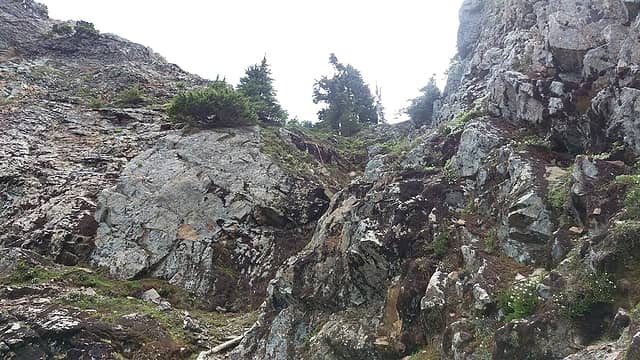 You can just make out the handline which was flung up in an unsual position this year (2015) 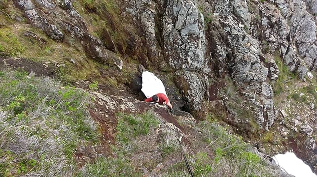 Me above as my buddy makes the tough move. 2016 ![we stayed the night at One Acre Lake (aka mosquito hell) [url=https://photos.app.goo.gl/eAJLSexJY1VjPP4B9]Link to video[/url]](https://cloud.nwhikers.net/bd81e50707b90fd5d0222d02dbe49b2c_427x240.jpg) we stayed the night at One Acre Lake (aka mosquito hell) Link to video
|
| Back to top |
|
|
|
|


![My friend not so fond of the ridge 2016 [url=https://photos.app.goo.gl/nzCnicsLSyDwuurF7]Link to video[/url]](https://cloud.nwhikers.net/d98526dc5dfeb160ab79fb99245d7125_o.gif#854x480+http://lh3.googleusercontent.com/Dy2IAMyb221GZ4e7AOevT9GyujVtaBH7OYLGxofepVOuLgk9bYZlprtJTztw6-B7De_EYLFB96pL99sz-YTVNCcGFYk0wtFRmJ9XVP94PxrzBdh8ACnj7EhICUhj5tOQ7hzyBneYjCQ=s0#854x480)
![we stayed the night at One Acre Lake (aka mosquito hell) [url=https://photos.app.goo.gl/eAJLSexJY1VjPP4B9]Link to video[/url]](https://cloud.nwhikers.net/bd81e50707b90fd5d0222d02dbe49b2c_o.gif#854x480+http://lh3.googleusercontent.com/L4ah7pdNkplS6fkJI5nYKDsD7rWhzhc-F-0Ue1kkEr9gj6eGtrOlIP_49U3A3qqRxmR5UlTLnih2mHhkXfSWUddJ4RVXG3A17V7boOcgCiHK3jJJCfGhBqB5O0o3XReEgur_bsVSDEw=s0#854x480)