| Previous :: Next Topic |
| Author |
Message |
catfish206
Member


Joined: 04 Jan 2017
Posts: 13 | TRs | Pics
Location: Seattle |
Hey folks. Was perusing topos and came across these lakes. Did a little research and it looks like one needs a Hancock Permit to access them from the west but I'm not finding a ton of info on getting to them with an approach from the Middle Fork side. Do you need a permit to even access at all? And if not, can you get close by way of Bessemer Road and head in that way? And if so, could one potentially camp at any of these lakes?
Because U Deserve What Every Individual Should Enjoy Regularly
Because U Deserve What Every Individual Should Enjoy Regularly
|
| Back to top |
  
|
|
cambajamba
Member

Joined: 05 Nov 2011
Posts: 339 | TRs | Pics
|
Yes, you 100% need the Campbell Global (or whoever these days) permit to access the land, even on foot.
|
| Back to top |
|
|
catfish206
Member
Joined: 04 Jan 2017
Posts: 13 | TRs | Pics
Location: Seattle |
Because U Deserve What Every Individual Should Enjoy Regularly
|
| Back to top |
|
|
RichP
Member

Joined: 13 Jul 2006
Posts: 5633 | TRs | Pics
Location: here |
|
RichP
Member
|
 Tue Jun 19, 2018 3:20 pm |
|
|
|
| Back to top |
|
|
jackchinook
Member

Joined: 28 Jan 2004
Posts: 684 | TRs | Pics
Location: Winthrop |
King County Parcel view site shows the same thing and the DNR's Mt Si NRCA site mentions the lake cluster specifically and gives some info on rec use rules/regs (Day Use Only).
|
| Back to top |
|
|
catfish206
Member
Joined: 04 Jan 2017
Posts: 13 | TRs | Pics
Location: Seattle |
So, yes they can be accessed but no you can't camp there. Got it. Thanks all!
Because U Deserve What Every Individual Should Enjoy Regularly
Because U Deserve What Every Individual Should Enjoy Regularly
|
| Back to top |
|
|
cambajamba
Member
Joined: 05 Nov 2011
Posts: 339 | TRs | Pics
|
What would that permitless access from the east look like though?
|
| Back to top |
|
|
Dante
Member
Joined: 16 Dec 2001
Posts: 2815 | TRs | Pics
|
|
Dante
Member
|
Wed Jun 20, 2018 8:08 am |
|
|
I'm interested in this, too. Last time I was up there was in the 1970s or 1980s with my dad and the Trailblazers. We accessed a trail to the lakes from the Hancock side. I'd like to go back, but don't want to pay for a Hancock (or whatever) permit.
|
| Back to top |
|
|
catfish206
Member
Joined: 04 Jan 2017
Posts: 13 | TRs | Pics
Location: Seattle |
On the ground it could be a different animal but the sat map shows what look like very discernible trails/roads.
Because U Deserve What Every Individual Should Enjoy Regularly
Because U Deserve What Every Individual Should Enjoy Regularly
|
| Back to top |
|
|
puzzlr
Mid Fork Rocks

Joined: 13 Feb 2007
Posts: 7220 | TRs | Pics
Location: Stuck in the middle |
|
puzzlr
Mid Fork Rocks
|
Sat Jun 23, 2018 3:55 pm |
|
|
That mess of disturbed ground near the ridge line is the active Crown Lakes LLC talus mine. They sold the land to the DNR for inclusion in the Mt Si NRCA but retained the rights to mine landscape rock for 30 years -- which expires in 2033. The old roads that crossed over the ridge from the Snoqualmie Tree Farm (now Campbell) have been completely decommissioned including slope restoration. But you can easily walk/ride the Bessemer road from the Middle Fork all the way up to the mine then cross over on foot. No permits required (other than a Discover Pass to park). The lakes are very slowly recovering from the inappropriate clear cut logging all around them. With a motorized Campbell permit it's possible to drive almost all the way to the lakes before you hit a gate.
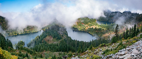 Crown Lakes pano 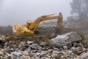 Excavator 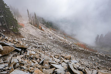 Landscape Rock mine
|
| Back to top |
|
|
|
|


