| Previous :: Next Topic |
| Author |
Message |
awilsondc
Member


Joined: 03 Apr 2016
Posts: 1324 | TRs | Pics
|
I have to plan most of my overnight trips well in advance. Weather is always a wild card, but I've lucked out so far. For this trip I wanted to do something in the North Cascades, but the weather for Friday was pretty bad almost everywhere. The only good weather was around the Stuart Range. I had done 3 of my last 5 trips in the general area and really didn't want to go back again, but you gotta go where the weather is decent, right? Plus I had never climbed Mount Stuart so it was game on! Only... Stuart is more of a day trip, really. So how to turn it into an overnighter? I had never been to the Ingalls Lake area so I thought I'd clean up some peaks around there on day one and hit up Stuart on day two. Still, it would be a fairly relaxed trip so I slept in, had breakfast with my family, and eventually made my way to the trailhead and started hiking around 11am.
Prior to getting to the trailhead I had to contend with some cows in the road who took their sweet time shuffling off to the side of the road, and a pokey old sheriff going 15-20 mph the last few miles to the trailhead. C'mon man, can't you go a little faster?! The parking lot was full and I got the last open spot. The trail to Ingalls Pass was nice and easy. I cruised along getting the legs warmed up and made it to the pass in a little over an hour. There were a few people resting at the pass as well as a family of mountain goats. I headed right at the pass and found a spot to drop my overnight pack for my first peak, Not Hinkhouse.
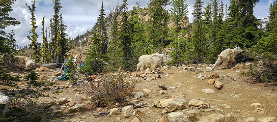 Mountain goats at Ingalls Pass 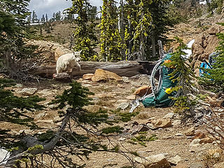 I caught this little guy mid jump apparently 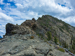 Not Hinkhouse 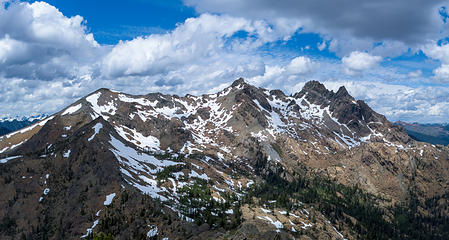 Fortune and Ingalls Peaks from Not Hinkhouse 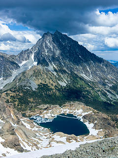 Moody Stuart 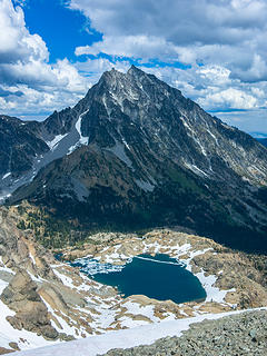 Light and Shadow 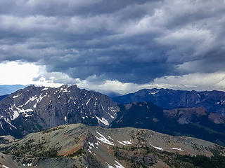 Stormy skies to the west 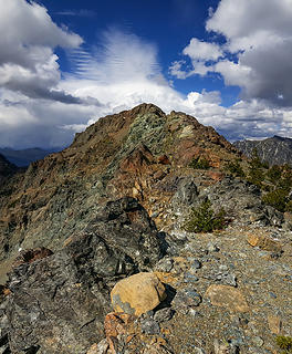 South Ingalls 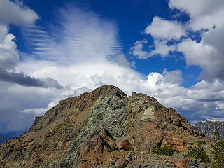 What do those clouds look like to you? 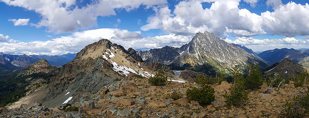 Pano from Fortune Peak 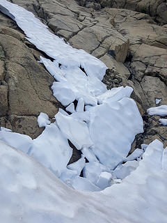 A dying snow finger 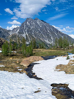 Headlight Basin 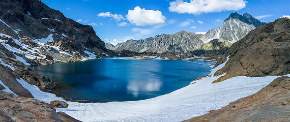 Ingalls Lake 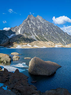 Evening light on Ingalls lake and Stuart 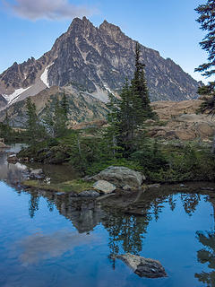 Stuart reflection 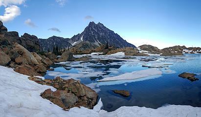 Tail end of Ingalls Lake 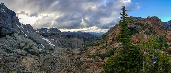 Stuart Pass 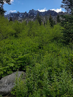 A little brush for breakfast. Fine way to start the day! 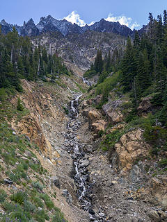 The drainage for Ulrich's. Route stays up high on the left side of the photo. 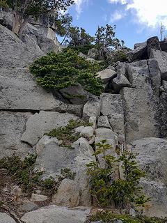 Early scrambling. Rock is solid. ~5800 ft maybe? 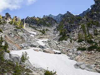 Entrance to Ulrich's Couloir ~6200 ft 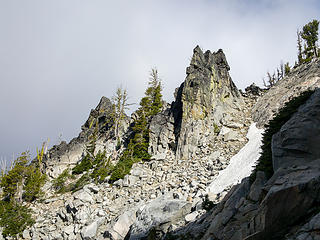 Gendarmes 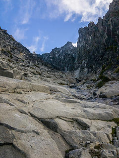 This terrain is typical of Ulrich's Couloir 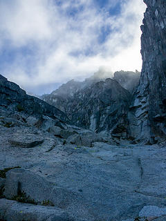 Fun clouds blowing through. 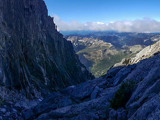 Looking down the coulior 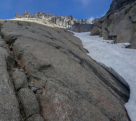 These slabs got steep with poor holds 20 feet up. I ascended this ice crusted snow finger. ~8400 ft 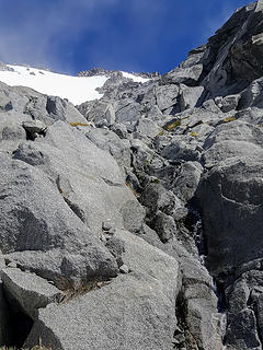 The summit is in sight 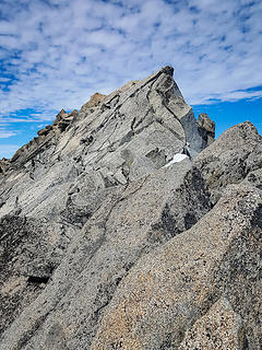 Mount Stuart summit block 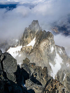 A climber prepares for his lead on one of the north side routes 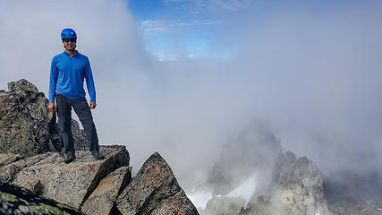 Yours truly just below Stuart's summit 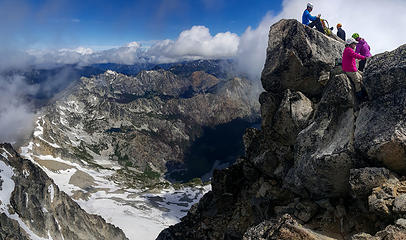 Stuart's summit and the other party 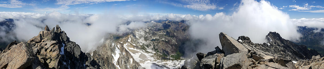 Mount Stuart summit panorama 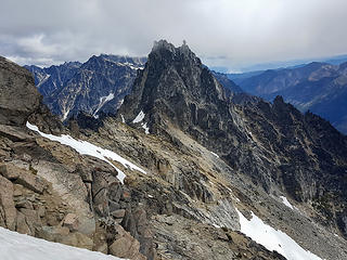 Sherpa 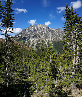 At first I thought these curved trees were an artifact of panorama mode, but I think they're legit - edit: nope, it's an artifact : / 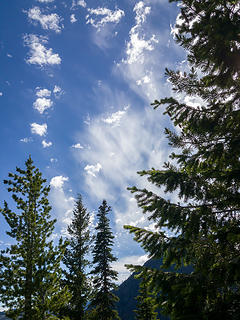 More fun clouds 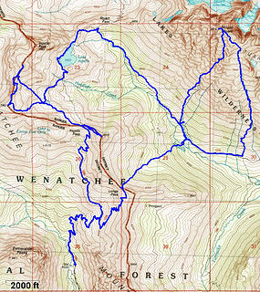 My route
|
| Back to top |
  
|
|
neek
Member

Joined: 12 Sep 2011
Posts: 2337 | TRs | Pics
Location: Seattle, WA |
|
neek
Member
|
 Tue Jul 10, 2018 6:29 am |
|
|
Very nice! I might try Ulrich's next month, although I'm one of the few people who think the Cascadian is fine. So much sand, it's like being at the beach.
|
| Back to top |
|
|
Bootpathguy
Member

Joined: 18 Jun 2015
Posts: 1790 | TRs | Pics
Location: United States |
I'm sometimes disappointed with clear blue cloudless skies. Clouds make everything better.
Nice report. Great images as usual. Thanks for sharing
Experience is what'cha get, when you get what'cha don't want
Experience is what'cha get, when you get what'cha don't want
|
| Back to top |
|
|
olderthanIusedtobe
Member
Joined: 05 Sep 2011
Posts: 7708 | TRs | Pics
Location: Shoreline |
I can't remember exactly when I hiked to Ingalls Pass, probably around a month ago. A bunch of snow has melted off since then, wow.
|
| Back to top |
|
|
geyer
Member

Joined: 23 May 2017
Posts: 463 | TRs | Pics
Location: Seattle |
|
geyer
Member
|
Tue Jul 10, 2018 12:52 pm |
|
|
Nice trip! Maybe I'll give it a go sometime too.
I know that steep slab feeling all too well. You go up about 5 feet and realize how stupid it was before creeping backing down and trying a different route. Glad the snow finger worked for you!
|
| Back to top |
|
|
awilsondc
Member
Joined: 03 Apr 2016
Posts: 1324 | TRs | Pics
|
| neek wrote: | | Very nice! I might try Ulrich's next month |
You're just the type of person I suspect would enjoy the route. I'm glad somebody likes the Cascadian, it gets such a bad reputation (deservedly so IMO) it could use a little love. 
| Bootpathguy wrote: | | I'm sometimes disappointed with clear blue cloudless skies. Clouds make everything better. |
Absolutely. That's the thing about questionable forecasts. Sometimes you get rain, sometimes you get phenomenal views with dramatic clouds! I'll take dramatic clouds over bluebird skies any day.
| olderthanIusedtobe wrote: | | I can't remember exactly when I hiked to Ingalls Pass, probably around a month ago. A bunch of snow has melted off since then, wow. |
It sure is melting fast out there! Even up at 9000 ft there wasn't much snow left. Summer is upon us!
| geyer wrote: | | I know that steep slab feeling all too well. You go up about 5 feet and realize how stupid it was before creeping backing down and trying a different route. Glad the snow finger worked for you! |
Yep. I mostly stayed in that crack system you see in the photo until I got to the steep slab. I've been there too and knew what it would be like. Sketchy. Didn't even bother testing a few moves. I was glad to be able to test out my Petzl Leopard FL and approach shoe combo for the first time on that snow finger. Worked great. Gives me some confidence in that combo going forward.
|
| Back to top |
|
|
Gimpilator
infinity/21M

Joined: 12 Oct 2006
Posts: 1684 | TRs | Pics
Location: Edmonds, WA |
Nice to see an Ulrich report. Very cool.  
|
| Back to top |
|
|
Brushbuffalo
Member

Joined: 17 Sep 2015
Posts: 1887 | TRs | Pics
Location: there earlier, here now, somewhere later... Bellingham in between |
| awilsondc wrote: | | the route is probably better later in summer when all the snow has melted |
Aaron, when I climbed Ulrichs in May 1974, it was snow nearly all the way. However, if I recall correctly we climbed rock on climber's left most of the way. It was fun and felt secure. We wanted to bivy on top, but we couldn't find two places to get comfy so we went down Cascadian, also mostly snow, until we found flattish boulders. My other two times on Stuart were up and down Cascadian with climbing students, also on snow, and we enjoyed it. ( I wished I had had skis).
So some like it, but I can see how it would be not so enjoyable when the snow is gone.
Incidentally, when you commented about the somewhat confusing route on Cascadian, that is the route that Rusk and party had an epic on over a century ago, recounted in Tales of a Western Mountaineer., a classic.
Passing rocks and trees like they were standing still
Passing rocks and trees like they were standing still
|
| Back to top |
|
|
awilsondc
Member
Joined: 03 Apr 2016
Posts: 1324 | TRs | Pics
|
| Brushbuffalo wrote: | | Aaron, when I climbed Ulrichs in May 1974, it was snow nearly all the way... |
Ulrich's seems to be a common ski descent, and I imagine it would be quite fun! Pretty much all the reports on Ulrich's I could find were ski trips in late winter and early spring and I suspect the route is good with snow. I'm pretty happy with the conditions I had though. Even a week later I still feel really good about this trip. It was unusually fulfilling for me for whatever reason.
It's interesting you bring up the Rusk epic. Not that I know anything about it, although I am interested to know what happened, but the Cascadian seems so well defined these days as a route. Not so much a century ago. Now you got me curious what happened!!!?! I'll have to look it up.
|
| Back to top |
|
|
Brushbuffalo
Member
Joined: 17 Sep 2015
Posts: 1887 | TRs | Pics
Location: there earlier, here now, somewhere later... Bellingham in between |
| awilsondc wrote: | | I'll have to look it up. |
Go find Tales of a Western Mountaineer by C.E. Rusk, published by The Mountainerrs in 1978.
Chapter XII , called The Mountain of Thrillls, tells all about his climb of Mount Stuart in 1920.
The entire book is fascinating history about a rather remarkable man.
Passing rocks and trees like they were standing still
Passing rocks and trees like they were standing still
|
| Back to top |
|
|
puzzlr
Mid Fork Rocks

Joined: 13 Feb 2007
Posts: 7220 | TRs | Pics
Location: Stuck in the middle |
|
puzzlr
Mid Fork Rocks
|
Thu Jul 19, 2018 1:09 pm |
|
|
BB, thanks for the reminder about Rusk's book. I had it but had not read much of it because it mostly about Mt Adams. It actually describes a number of the early ascents of Stuart, not just the exciting one with the unplanned bivouac.
|
| Back to top |
|
|
|
|
You cannot post new topics in this forum
You cannot reply to topics in this forum
You cannot edit your posts in this forum
You cannot delete your posts in this forum
You cannot vote in polls in this forum
|
Disclosure: As an Amazon Associate NWHikers.net earns from qualifying purchases when you use our link(s). |


