| Previous :: Next Topic |
| Author |
Message |
puzzlr
Mid Fork Rocks


Joined: 13 Feb 2007
Posts: 7220 | TRs | Pics
Location: Stuck in the middle |
|
puzzlr
Mid Fork Rocks
|
 Sat Jun 30, 2018 9:42 pm |
|
|
I found a copy of an oblique sketch map of the Mountain Loop area. Follow these to my flickr site for a hi-res version. They are undated but the Big Four Inn is shown. That burned down in 1949 so I'm using a date of 1940.
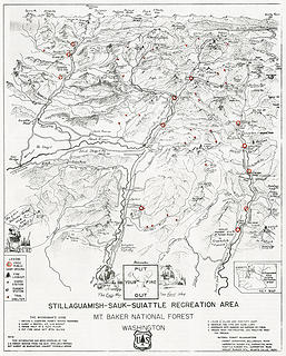 Mountain Loop Front 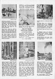 Mountain Loop Back
|
| Back to top |
  
|
|
RodF
Member

Joined: 01 Sep 2007
Posts: 2593 | TRs | Pics
Location: Sequim WA |
|
RodF
Member
|
Sun Jul 01, 2018 2:04 pm |
|
|
Very cool! A wealth of trails, shelters, lookouts now gone...
which would be used now, more than ever.
"of all the paths you take in life, make sure a few of them are dirt" - John Muir
"the wild is not the opposite of cultivated. It is the opposite of the captivated - Vandana Shiva
"of all the paths you take in life, make sure a few of them are dirt" - John Muir
"the wild is not the opposite of cultivated. It is the opposite of the captivated - Vandana Shiva
|
| Back to top |
|
|
Kim Brown
Member

Joined: 13 Jul 2009
Posts: 6899 | TRs | Pics
|
Cool, puzzlr. Note the old trail to Green Mountain Lookout; that was abandoned in 1948 when the road was put in for logging (I'll have to double check on the year, but pretty sure it was 1948). And several trail connections aren't there that made up the Cascade Crest Trail; it did exist then, but perhaps some connections were boot paths.
Some of this map looks very much like the hand drawn Nels Bruseth map, unofficially dated 1931. It's online somewhere; I'll see if I can find it. Perhaps George Winters posted it on this site. Bruseth took one of the photos in the brochure. He died in 1957.
Whitechuck trail is on the south side of the river. But I think it was put on the north side relatively late, anyway (1960's?).
But yeah, since you know when the Inn burned down, it was before then anyway, so my post doesn't help pinpoint it closer to your date!
"..living on the east side of the Sierra world be ideal - except for harsher winters and the chance of apocalyptic fires burning the whole area."
Bosterson, NWHiker's marketing expert
"..living on the east side of the Sierra world be ideal - except for harsher winters and the chance of apocalyptic fires burning the whole area."
Bosterson, NWHiker's marketing expert
|
| Back to top |
|
|
Kim Brown
Member
Joined: 13 Jul 2009
Posts: 6899 | TRs | Pics
|
Wait. What's the deal with the Downey Creek trail(s)? & look how far Sulphur Cr trail goes. I recall Karen Sykes saying that trail went waaay up Sulphur Creek back in the 20's or so.
Huckleberry Mtn is missing
"..living on the east side of the Sierra world be ideal - except for harsher winters and the chance of apocalyptic fires burning the whole area."
Bosterson, NWHiker's marketing expert
"..living on the east side of the Sierra world be ideal - except for harsher winters and the chance of apocalyptic fires burning the whole area."
Bosterson, NWHiker's marketing expert
|
| Back to top |
|
|
Kim Brown
Member
Joined: 13 Jul 2009
Posts: 6899 | TRs | Pics
|
Here's the Bruseth map. I wonder if he did work on the USFS brochure.
"..living on the east side of the Sierra world be ideal - except for harsher winters and the chance of apocalyptic fires burning the whole area."
Bosterson, NWHiker's marketing expert
"..living on the east side of the Sierra world be ideal - except for harsher winters and the chance of apocalyptic fires burning the whole area."
Bosterson, NWHiker's marketing expert
|
| Back to top |
|
|
Schroder
Member

Joined: 26 Oct 2007
Posts: 6722 | TRs | Pics
Location: on the beach |
|
Schroder
Member
|
Mon Jul 02, 2018 12:52 pm |
|
|
Great find 
| Quote: | | Here's the Bruseth map. I wonder if he did work on the USFS brochure. |
Bruseth is credited on one of the photos, as is Huntoon
|
| Back to top |
|
|
Hulksmash
Cleaning up.

Joined: 20 Apr 2008
Posts: 7113 | TRs | Pics
Location: Arlington |
|
Hulksmash
Cleaning up.
|
Sun Aug 05, 2018 5:17 pm |
|
|
Hmm it's missing a couple of trails.
The one that branches off the Boulder River, that follows Boulder Ridge to Whitehorse. Still there festooned with telephone wires and insulators. Wonder when it was abandoned?
Used to be a trail across the ridge from White Chuck to Prairie. Still bits and pieces not erased by logging.
"Bears couldn't care less about us....we smell bad and don't taste too good. Bugs on the other hand see us as vending machines." - WetDog
Albuterol! it's the 11th essential
"Bears couldn't care less about us....we smell bad and don't taste too good. Bugs on the other hand see us as vending machines." - WetDog
Albuterol! it's the 11th essential
|
| Back to top |
|
|
|
|


