| Previous :: Next Topic |
| Author |
Message |
radka
Member


Joined: 28 Mar 2010
Posts: 57 | TRs | Pics
|
|
radka
Member
|
 Fri Aug 17, 2018 11:10 am |
|
|
|
| Back to top |
  
|
|
rubywrangler
Member

Joined: 04 Aug 2015
Posts: 511 | TRs | Pics
|
PCT is open according to the last inciweb update. And that section is not listed as closed on the PCTA website either.
|
| Back to top |
|
|
BeyondLost
Crazy Bob
Joined: 07 Jul 2007
Posts: 3601 | TRs | Pics
Location: Whidbey Island, WA |
McLeod Fire: 10,000 acres; 0% contained
● Personnel:352
Up from 4000 acres yesterday.
Crescent Mtn fire just ordered Level 3 evacuation west of Buttermilk Creek
|
| Back to top |
|
|
treeswarper
Alleged Sockpuppet!
Joined: 25 Dec 2006
Posts: 11279 | TRs | Pics
Location: Don't move here |
|
treeswarper
Alleged Sockpuppet!
|
Sat Aug 18, 2018 3:47 pm |
|
|
Drove home from Lewiston, Idaho today and the smoke started at Wilbur and got worse as I neared Omak. Omak is socked in big time and there was/is a brush fire about 3 miles to the north.
I may restock my trailer and take off again.
What's especially fun about sock puppets is that you can make each one unique and individual, so that they each have special characters. And they don't have to be humananimals and aliens are great possibilities
What's especially fun about sock puppets is that you can make each one unique and individual, so that they each have special characters. And they don't have to be humananimals and aliens are great possibilities
|
| Back to top |
|
|
AlpineRose
Member
Joined: 08 May 2012
Posts: 1953 | TRs | Pics
|
No wonder. Omak (and Twisp) air quality is at the "hazardous" level.
|
| Back to top |
|
|
HitTheTrail
Member

Joined: 30 Oct 2007
Posts: 5460 | TRs | Pics
Location: 509 |
My wife and I spent 4 days at Ocean Shores this week to get away from Wenatchee smoke (and celebrate our 40th anniversary). We had a beach cabin and could hardly see the water, so never walked the beach the entire time. But had a nice relaxing time while there. As we were leaving a nice breeze was blowing and we could actually see boats/ships out in the water.
|
| Back to top |
|
|
zephyr
aka friendly hiker

Joined: 21 Jun 2009
Posts: 3370 | TRs | Pics
Location: West Seattle |
|
zephyr
aka friendly hiker
|
Sat Aug 18, 2018 9:25 pm |
|
|
| HitTheTrail wrote: | | We had a beach cabin and could hardly see the water, so never walked the beach the entire time. |
Congratulations! HTT, you and your wife. That's quite a milestone.
Re: your comment. Was this due to smoke too? It's hard to get away from this stuff. ~z
|
| Back to top |
|
|
Ski
><((((°>

Joined: 28 May 2005
Posts: 12832 | TRs | Pics
Location: tacoma |
|
Ski
><((((°>
|
Sat Aug 18, 2018 11:35 pm |
|
|
"I shall wear white flannel trousers, and walk upon the beach.
I have heard the mermaids singing, each to each."
|
| Back to top |
|
|
HitTheTrail
Member
Joined: 30 Oct 2007
Posts: 5460 | TRs | Pics
Location: 509 |
| zephyr wrote: | | Congratulations! HTT, you and your wife. That's quite a milestone.
Re: your comment. Was this due to smoke too? It's hard to get away from this stuff. ~z |
Thanks folks!
This photo was taken with my phone from the deck of our cabin. You can see the haze. One morning we woke up and could barely tell there were structures on the spit across the water. But we are glad we went. Otherwise it would have been a missed opportunity.
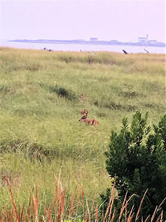 Ocean Shores
|
| Back to top |
|
|
Joey
verrry senior member

Joined: 05 Jun 2005
Posts: 2799 | TRs | Pics
Location: Redmond |
|
Joey
verrry senior member
|
Sun Aug 19, 2018 7:08 am |
|
|
Last night (Saturday 8/18) there was an infrared overflight for each fire you see below. Using that data, fire staff determined the latest perimeter and acres burned.
Crescent Mountain fire, aka Gilbert fire.
24,853 acres
Open online map:
https://mappingsupport.com/p2/gissurfer.php?center=48.388168,-120.486031&zoom=12&basemap=ESRI_scanned_topo_USA&fire=WA,Gilbert
Cougar Creek fire.
36,550 acres
Open online map:
https://mappingsupport.com/p2/gissurfer.php?center=47.812930,-120.485687&zoom=12&basemap=ESRI_scanned_topo_USA&fire=WA,cougar_creek
McLeod fire.
11,663 acres
Open online map:
https://mappingsupport.com/p2/gissurfer.php?center=48.685527,-120.363464&zoom=12&basemap=ESRI_scanned_topo_USA&fire=WA,McLeod
|
| Back to top |
|
|
rubywrangler
Member
Joined: 04 Aug 2015
Posts: 511 | TRs | Pics
|
The map is showing a couple orange dots east of Kindy creek near buckindy that I hadn't noticed before. Any info on that area?
|
| Back to top |
|
|
Joey
verrry senior member
Joined: 05 Jun 2005
Posts: 2799 | TRs | Pics
Location: Redmond |
|
Joey
verrry senior member
|
Sun Aug 19, 2018 3:05 pm |
|
|
|
| Back to top |
|
|
Get Out and Go
Member

Joined: 13 Nov 2004
Posts: 2128 | TRs | Pics
Location: Leavenworth |
From the Wenatchee World| Quote: | | Updated, 2:45 p.m. Sunday: PLAIN A Level 1 fire advisory notification is in place residents in the Plain area due wind changes on the Cougar Creek Fire north of Entiat.
Winds have shifted directions and are currently pushing the 36,000-plus-acre fire to the southwest, according to Chelan County Emergency Management.
Areas included in the Level 1 notices are:
Chumstick Road north to Merry Canyon (both sides of the road)
Merry Canyon; Second Creek and Moon Canyon
Plain, Ponderosa Pines, Plain River Road and other nearby subdivisions
Chiwawa Loop Road to include Chiwawa River Pines
All areas from Fish Lake and Lake Wenatchee to Coles Corner
Crews on Sunday are working the fires western and southern edges, looking to prevent spread to the west, according to the Okanogan-Wenatchee National Forest. |
I noticed those hot spots that are west of the Entiat Summit Road, especially a couple around Sugarloaf. Whether false positive or not, sounds like they are taking them seriously. Visible satellite and Fish Lake weather station confirm that the wind is coming from the NE, although gentle. Keeping fingers crossed for Plain and the Chumstick, where many reside.
"These are the places you will find me hiding'...These are the places I will always go."
(Down in the Valley by The Head and The Heart)
"Sometimes you're happy. Sometimes you cry.
Half of me is ocean. Half of me is sky."
(Thanks, Tom Petty)
"These are the places you will find me hiding'...These are the places I will always go."
(Down in the Valley by The Head and The Heart)
"Sometimes you're happy. Sometimes you cry.
Half of me is ocean. Half of me is sky."
(Thanks, Tom Petty)
|
| Back to top |
|
|
HitTheTrail
Member
Joined: 30 Oct 2007
Posts: 5460 | TRs | Pics
Location: 509 |
| Get Out and Go wrote: | | Updated, 2:45 p.m. Sunday: PLAIN A Level 1 fire advisory notification is in place residents in the Plain area due wind changes on the Cougar Creek Fire north of Entiat |
That just got updated to a level 2 as per this news release:
Cougar Creek Fire - Evacuation Level Changes effective today at 4:30pm: As of 4:30pm today, 8/20/18, Chelan County is implementing Level 2 (GET SET) evacuation notifications on Chiwawa Loop Rd from Plain out to the intersection with Chiwawa River Rd, both sides of the roadway. This includes Chiwawa River Pine Community and Shugart Flats Community and all roads that intersect with the Chiwawa Loop Road in the affected area. Plain is remaining at a Level 1.
|
| Back to top |
|
|
mbravenboer
Member
Joined: 20 Oct 2013
Posts: 1422 | TRs | Pics
Location: Seattle |
I really hope this is just the intensity of the smoke plume and the fire did not actually jump Lake Chelan ...
|
| Back to top |
|
|
|
|


