| Previous :: Next Topic |
| Author |
Message |
Chief Joseph
Member


Joined: 10 Nov 2007
Posts: 7703 | TRs | Pics
Location: Verlot-Priest Lake |
This hike has been on my radar for quite some time especially since I visit Priest Lake quite often. Today I decided to take the plunge with great hiking weather for a mid day hike at around 65 degrees. (Love It!). Perfect weather, a bit of a breeze, zero bugs and some good company from other hikers on the trail, there were 4 cars at the TH, which surprised me for a Tuesday, although there a lot of tourists there until after Labor Day.
The following quote echoed in my head while trying to find the TH.... 
| Spotly wrote: | The crux for that hike is just finding the trailhead  |
From this 9 year old report. https://www.nwhikers.net/forums/viewtopic.php?t=7977099&highlight=hunt+lk+lake
I found a report that seemed to have pretty definitive directions, which turned out to be a bit off.
Although there are many forks in this road and when it's a 50-50 shot, I am wrong 90% of the time. (I don't play roulette). So I came to a point where the road forked and the sign # was obliterated by some "redneck artwork" using what I assume to have been a 12 gauge shotgun.  So I ventured to the right and within a mile or so came to another fork. According to my spotty directions, left was the way. So away I went in my 2wd four banger Ford Ranger with street tires.
  It began innocently enough as many debacles are wont to do. So on I went a ways until I came to yet another fork...left looked good, so off I went.
In a bit less than a mile I began to encounter woops and large and loose rocks with no place to turn around, I proceeded onward and upward, hoping it would get better (it didn't). So I proceeded to (barely) climb this gnarly hill, luckily with minimal exposure, nowhere to turn around and unable to back down for about 1/4 mile until I came upon a place to turn back, and clean out my drawers.
So down I went and took the other fork...nothing too bad happened there but that wasn't the way either, arrrgh! So I proceeded back down to the previous "fork" when the blown up sign was. I first passed it by feeling that I had really had enough frickin' forks for one day.
However, as I was cruising down the road about a 1/2 mile later I thought "you know what?...I have come this far, I should try just one more "fork". (did I ever tell you that I don't give up easily and am a glutton for punishment?).
So, up I went on what I hoped would be my last "fork" of the day...(there ended up being one more).....then a miracle happened, in 2.2 miles up I came to another "Fork" and this one actually had a sign pointing left and to Hunt Lake!!!! Halle-frickin'-lukya!!!!!! It began innocently enough as many debacles are wont to do. So on I went a ways until I came to yet another fork...left looked good, so off I went.
In a bit less than a mile I began to encounter woops and large and loose rocks with no place to turn around, I proceeded onward and upward, hoping it would get better (it didn't). So I proceeded to (barely) climb this gnarly hill, luckily with minimal exposure, nowhere to turn around and unable to back down for about 1/4 mile until I came upon a place to turn back, and clean out my drawers.
So down I went and took the other fork...nothing too bad happened there but that wasn't the way either, arrrgh! So I proceeded back down to the previous "fork" when the blown up sign was. I first passed it by feeling that I had really had enough frickin' forks for one day.
However, as I was cruising down the road about a 1/2 mile later I thought "you know what?...I have come this far, I should try just one more "fork". (did I ever tell you that I don't give up easily and am a glutton for punishment?).
So, up I went on what I hoped would be my last "fork" of the day...(there ended up being one more).....then a miracle happened, in 2.2 miles up I came to another "Fork" and this one actually had a sign pointing left and to Hunt Lake!!!! Halle-frickin'-lukya!!!!!!  At that point you are 3.4 miles from the TH....the final 1.5 after a sharp uphill turn to the right, being pretty rough with a lot of dips and some large rocks that would cause damage for low clearance vehicles, but it wasn't very steep, so I creeped along mostly in 1st gear. Arriving at the TH about 2 pm....around 2 1/2 hours after I left on a 45 minute trip. O well, I made it in one piece, that's the main thing!
Anyway, sorry for that lengthy diatribe, I debated giving specific directions since I don't want to encourage too much traffic there.
However, while speaking with a couple of ladies and their children at the lake I discovered that she had also made the same mistake I did, although in 4wd Ford Explorer. They went beyond where I turned around and were on a very exposed and rocky ridge (The 'road' to Chimney rock-Mt Roothaan) and nearly rolled their vehicle off the cliff attempting to turn around. (3 people were just killed over near Usk doing just that) so I decided that personal safety and actually being able to find the TH were much more important.
But, the rocks were brutal, the fishing sucks, and there are multitudes of Griz in the area, so stay away!
Ok, finally on to the actual hike, which is pretty much an afterthought at this point.
I had read that the boulder field is brutal and pretty long (1/2 mile?)...and that there are arrows in faded orange pointing the way with just spots on some boulders. They were not ascetically unsightly since they are really old and faded, there are also ribbons along the way, so getting lost would be extremely difficult (even for me)....I myself like rock hopping on boulders but those with bad knees and ankles might have issues.
I went up pretty much in the middle of the boulder field although on the return trip I found that keeping high and to the left was the best route. So, past the boulder field you have to climb to a saddle (about 2 miles total RT and 800 ft gain), you drop down on an obvious trail to a large tarn. Continue on the trail east just a few hundred feet to reach Hunt Lake. YaHOOO!!!!
Unlike many lakes I have visited, you don't have to drop down far at all, therefore not having to climb back out. I visited with a few of the other hikers at the lake, cleaned a bit of trash out of the firepit (hot dogs) and a container of salmon eggs left on a rock. Didn't stay long as I didn't want to be late for dinner (mom's cooking).
At that point you are 3.4 miles from the TH....the final 1.5 after a sharp uphill turn to the right, being pretty rough with a lot of dips and some large rocks that would cause damage for low clearance vehicles, but it wasn't very steep, so I creeped along mostly in 1st gear. Arriving at the TH about 2 pm....around 2 1/2 hours after I left on a 45 minute trip. O well, I made it in one piece, that's the main thing!
Anyway, sorry for that lengthy diatribe, I debated giving specific directions since I don't want to encourage too much traffic there.
However, while speaking with a couple of ladies and their children at the lake I discovered that she had also made the same mistake I did, although in 4wd Ford Explorer. They went beyond where I turned around and were on a very exposed and rocky ridge (The 'road' to Chimney rock-Mt Roothaan) and nearly rolled their vehicle off the cliff attempting to turn around. (3 people were just killed over near Usk doing just that) so I decided that personal safety and actually being able to find the TH were much more important.
But, the rocks were brutal, the fishing sucks, and there are multitudes of Griz in the area, so stay away!
Ok, finally on to the actual hike, which is pretty much an afterthought at this point.
I had read that the boulder field is brutal and pretty long (1/2 mile?)...and that there are arrows in faded orange pointing the way with just spots on some boulders. They were not ascetically unsightly since they are really old and faded, there are also ribbons along the way, so getting lost would be extremely difficult (even for me)....I myself like rock hopping on boulders but those with bad knees and ankles might have issues.
I went up pretty much in the middle of the boulder field although on the return trip I found that keeping high and to the left was the best route. So, past the boulder field you have to climb to a saddle (about 2 miles total RT and 800 ft gain), you drop down on an obvious trail to a large tarn. Continue on the trail east just a few hundred feet to reach Hunt Lake. YaHOOO!!!!
Unlike many lakes I have visited, you don't have to drop down far at all, therefore not having to climb back out. I visited with a few of the other hikers at the lake, cleaned a bit of trash out of the firepit (hot dogs) and a container of salmon eggs left on a rock. Didn't stay long as I didn't want to be late for dinner (mom's cooking).  I will (attempt) to post some pics and convey some accurate directions to the TH in a bit. Thanks for reading!
Go placidly amid the noise and waste, and remember what comfort there may be in owning a piece thereof.
Go placidly amid the noise and waste, and remember what comfort there may be in owning a piece thereof.
|
| Back to top |
  
|
|
Chief Joseph
Member
Joined: 10 Nov 2007
Posts: 7703 | TRs | Pics
Location: Verlot-Priest Lake |
Drive north from Priest river about 20 miles and turn right at the turnoff and proceed without turning to the town of Coolin, upon entering Coolin, turn right on Cavanaugh Bay road. Travel 7.4 miles to FS road # 24, (the second gravel road on the right, clearly marked #24). After about 4 miles you will reach a junction (fork) with road #25, go to the right staying on #24. In about a half a mile you will come to another fork where the shot up sign is and there is actually a difficult to notice signpost reading hunt lake and pointing left. So obviously you turn left here and proceed about 2 miles you will come to the last fork in the road and a sign for Hunt lake, then proceed 3.5 miles to the TH and as I mentioned I would not recommend driving your Prius the final 1.5 miles. 9 miles total from the initial turn off the highway.
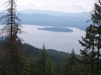 Priest lake looking SW 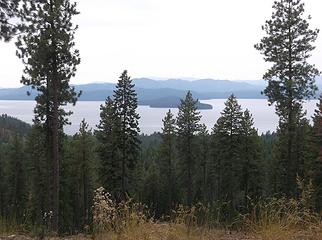 Priest lake from above. 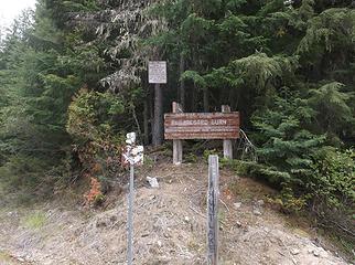 go left young man and how did I miss the sign? 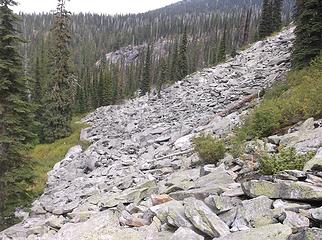 Boulder field-start of hike 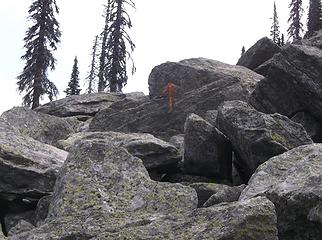 see the arrows? lol 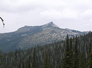 looking NW 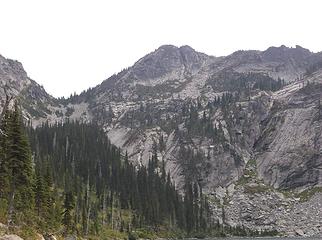 looking east toward ridge and off trail route to fault lake 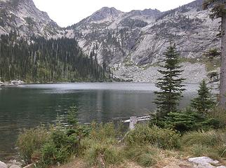 Hunt lake very nice!
Go placidly amid the noise and waste, and remember what comfort there may be in owning a piece thereof.
Go placidly amid the noise and waste, and remember what comfort there may be in owning a piece thereof.
|
| Back to top |
|
|
RichP
Member

Joined: 13 Jul 2006
Posts: 5634 | TRs | Pics
Location: here |
|
RichP
Member
|
 Wed Aug 29, 2018 6:04 am |
|
|
Nice, Chief. As an Idahoan now I'm looking forward to checking out this area (and many others) eventually. I was out myself yesterday tagging some hills a bit further south.
|
| Back to top |
|
|
Nancyann
Member

Joined: 28 Jul 2013
Posts: 2318 | TRs | Pics
Location: Sultan Basin |
|
Nancyann
Member
|
Wed Aug 29, 2018 1:26 pm |
|
|
So good to see a trip report from you CJ. You always write in such an entertaining way!
Just watched River of No Return last night, made in 1953 with a star-studded cast including Marilyn Monroe. Some of the footage was shot on the Salmon River and was pretty amazing, which reminded me that I need to get over to Idaho one of these days, havent seen that area for way too many years, so beautiful!
|
| Back to top |
|
|
Chief Joseph
Member
Joined: 10 Nov 2007
Posts: 7703 | TRs | Pics
Location: Verlot-Priest Lake |
Thanks Nancy and Rich, I figured it was about time I contributed something other than sarcasm and bad jokes. Plus there are very few reports on this lake. As I said I wasn't sure about posting the info, but there are enough people getting lost out there as it is, so maybe this will save someone some hardship. Next on my list is Lookout Mt and Lake, then Roothaan-Chimney rock (no, I won't climb the chimney)  Definitely want to do an over-nighter at Hunt around this time next year. There were no bugs at all so it must have already froze up there. Definitely want to do an over-nighter at Hunt around this time next year. There were no bugs at all so it must have already froze up there.
Go placidly amid the noise and waste, and remember what comfort there may be in owning a piece thereof.
Go placidly amid the noise and waste, and remember what comfort there may be in owning a piece thereof.
|
| Back to top |
|
|
|
|
You cannot post new topics in this forum
You cannot reply to topics in this forum
You cannot edit your posts in this forum
You cannot delete your posts in this forum
You cannot vote in polls in this forum
|
Disclosure: As an Amazon Associate NWHikers.net earns from qualifying purchases when you use our link(s). |


