| Previous :: Next Topic |
| Author |
Message |
Brucester
Member

Joined: 02 Jun 2013
Posts: 1102 | TRs | Pics
Location: Greenwood |
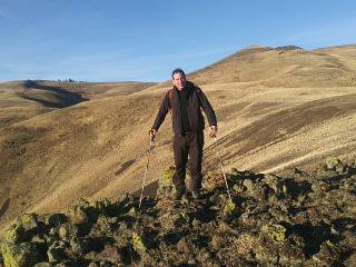
With a couple days off I had a few ideas on where to go. Wanting to stay close to home yet wanting a wilderness experience. Something challenging and there you have it, Revolution.
Much has changed on the Middle Fork. For the better yet I was disappointed to read camping is NOT allowed along the Granite Creek corridor. Not even at the lakes? DNR land. Such a shame because a I was asked if I was camping a few time. I guess if you don't read the fine print you wouldn't have known!
The trail in is much different than I remember it being. Very tame from the upper Granite Creek TH. Manicured.... Never the less on my way back down I would come to appreciate this after my day of adventure!
The trail up to the unofficial? trail that turns left to the cabin starts out easy then gradually becomes rugged.
After turning left to go to the cabin the decommissioned road route has become harder to follow.
If you've gone xc then you're in luck because you're likely not to see anyone and you'll most likely be able to stay on 'trail easier than they will. The road has disappeared in many places while in others it's obvious.
The cabin always grabs my attention. It's just cool. It should be rented out IMO. It seems to be well made and in in need of maintenance if it is to remain in good shape. The south side roof panels are gone as are more of the plywood sheathing that I've seen before. It'd be a fun local history restoration project! Under new ownership I have read. Terra something?
On my map (sourced from this site) I was to drop down a road and traverse through this green hell I've been through the last time to get to Rev. Not this time. I stayed high just to see if I was comfortable with the exposure.
There were a few places I just didn't look down or over think as I kept moving forward. One down climb I just limited my time thinking and thought out the climb with out letting the brain freeze set in.
Soon enough I rose to the top. A good feeling since a few places along the high route had me wondering what the h*ll I was doing there alone in the first place.
At first no views but this changed momentarily. I opened yet another Puzzlingly perfect Nalgene bottle. Opening it the clouds parted and the world arounf me was in clear view! Thanks Monty!
I made it. Yet another register found and signed. I'm geeting somewhere!
I retraced the high route back. I didn't even descend to lower ground. I kept Ozzy+ Randy Rhodes "Crazy Train" in my head and just progressed through section that I might over thing and get messed up. Who needs iPods?
Back at the cabin is where this adventure gets crazy. I had remembered TypeE mentioning Zorro point so I had this idea of descending to it, maybe seeing if the old Z road was easy to follow or just return to the cabin. An "easy" out and back I thought. It wasn't bad in the begining Saw some evidence I wasn't alone....
Seeing this was an unsettling feeling like the time I was trying to do Palmer and seeing this stuff. I'm alone but I'm not kinda thing. Anyway as I reached the wall of new growth I soon realized it wasn't as easy and I was goung to get wet again. Maybe not as wet as when I did the Lions Mane but it was going to be a "hiker wash" again.
Long story short it sucked. I don't recomment it without snow. I tried to descend the decommistioned road but it was so well done it wasnt a question of following it, it was the obsticles along the route so I turned around and headed back to the cabin. I did though take a different road to the north of the ridge that was hellacious in it's own way to avoid the new growth fun stuff.
I made it back to the cabin and descended rapidly to beat the sun. I failed, at the junction to the upper TH parking light was slim. Out came the head lamp of which I held in my hand and made it back to my rig in the dark.
Glad to see the gate was still open!
Just guessing:
5,500 gain
20 miles.
8-9 hours? Who cares? Hella fun!!!
Kudos to Columbia for making thin stretchy pants that dry quickly and La Sportiva for making high quality shoes that grip everywhere!
Lesson learned? Maybe skip the lessor points and bag lakes instead!
 Fedor Fedor
Fedor |
| Back to top |
  
|
|
Bryan K
Shameless Peakbagger

Joined: 29 Sep 2005
Posts: 5129 | TRs | Pics
Location: Alaska |
|
Bryan K
Shameless Peakbagger
|
 Mon Sep 03, 2018 11:50 am |
|
|
Nice job! We had lofty aspirations of reaching that one year in the winter but very heavy snowfall thwarted our desire to break that much trail.
|
| Back to top |
|
|
nordique
Member

Joined: 04 May 2008
Posts: 1086 | TRs | Pics
|
|
nordique
Member
|
Mon Sep 03, 2018 7:25 pm |
|
|
VERY impressive and very long day! Now none of us have to do it! Thanks for the photos!
|
| Back to top |
|
|
puzzlr
Mid Fork Rocks

Joined: 13 Feb 2007
Posts: 7220 | TRs | Pics
Location: Stuck in the middle |
|
puzzlr
Mid Fork Rocks
|
Mon Sep 03, 2018 9:07 pm |
|
|
It's a big deal to get to Revolution in a day. I failed 3 times before I made it and then only because I bivvied at Thompson Point. I'm glad to see the register is still there.
Do you have any shots of the brush on the road up to Thompson Point? I didn't realize that was getting overgrown because it was never "decommissioned" like many of the other roads, including the one you were on to Zorro Point. Those have been impassible for a while now after the regreening by MTSG in the late 90s.
Re the cabin, I heard that the DNR was going to destroy it this year but it didn't happen (at least not yet). I think the access is too difficult for it to be maintained as a hiker cabin as nice as that would be.
|
| Back to top |
|
|
Brucester
Member
Joined: 02 Jun 2013
Posts: 1102 | TRs | Pics
Location: Greenwood |
I don't have overgrown pics. After the last lake junction and you go left that's where it has become thick.
And there's one spot that's really wet below the spring mini waterfall.
|
| Back to top |
|
|
puzzlr
Mid Fork Rocks
Joined: 13 Feb 2007
Posts: 7220 | TRs | Pics
Location: Stuck in the middle |
|
puzzlr
Mid Fork Rocks
|
Mon Sep 03, 2018 9:38 pm |
|
|
It's obvious we need more people hiking up there to keep the road/trail clear  Your report helps with that noble cause!
|
| Back to top |
|
|
some names
Member

Joined: 08 Jan 2012
Posts: 244 | TRs | Pics
|
Nice trip report!
We were up there in June of this year with good views. Peakbaggers may think its a little brushy, but viewbaggers will think this summit is top notch! Weve been there in snow and without snow. Spring snow does make it easier. Adding a few pics to the thread to entice others . . .
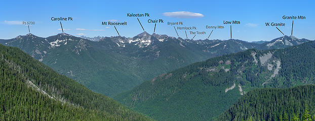 Pano East from Thompson Pt , 24 Jun 2018 - labeled 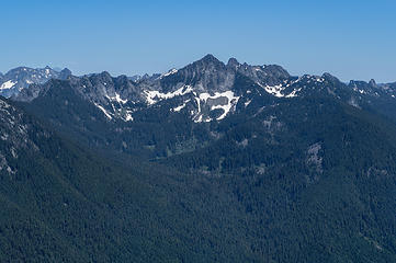 View East from Revolution Pk 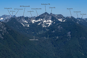 Labeled 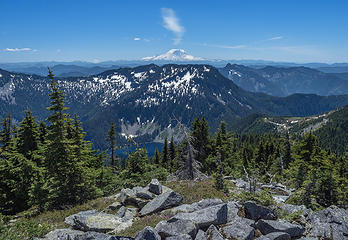 View South from Revolution Pk 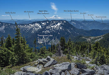 labeled  View West from Revolution Pk 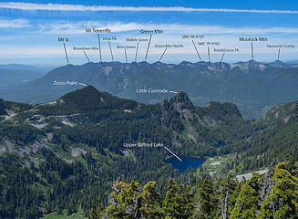 Labeled  View North from Revolution Pk 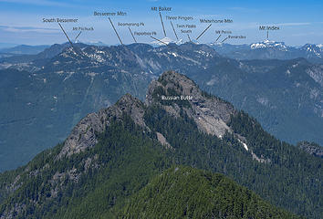 Labeled
somesignaturehere and somesignaturethere
Fedor
somesignaturehere and somesignaturethere
Fedor
|
| Back to top |
|
|
RichP
Member

Joined: 13 Jul 2006
Posts: 5634 | TRs | Pics
Location: here |
|
RichP
Member
|
Tue Sep 04, 2018 9:23 pm |
|
|
Nice summit pics, some names. I'm enticed.
|
| Back to top |
|
|
Justus S.
Member

Joined: 17 Nov 2004
Posts: 1298 | TRs | Pics
Location: WA |
Nice, I've always wanted to go up in the snow, but you make is sound reasonable anytime of year. 
|
| Back to top |
|
|
fourteen410
Member

Joined: 23 May 2008
Posts: 2628 | TRs | Pics
|
| puzzlr wrote: | | Re the cabin, I heard that the DNR was going to destroy it this year but it didn't happen (at least not yet). |
Why would they do that?
|
| Back to top |
|
|
|
|


