| Previous :: Next Topic |
| Author |
Message |
kitya
Fortune Cookie


Joined: 15 Mar 2010
Posts: 842 | TRs | Pics
Location: Duvall, WA |
|
kitya
Fortune Cookie
|
 Sun Sep 02, 2018 1:32 pm |
|
|
For solitude I like going to Chiwaukum range and it never disappoints, not even on a long Labor day weekend. This time me and Cookie visited the south-eastern end of the Chiwaukum range and it was beautiful. The sky was clear, but the air is fresh and cool accentuated by the views of clouds west and forest fire smoke north.
Hatchery Creek road (FR 7905) is drivable in a regular sedan and is not in the worst of conditions for a forest road, but not very pleasant at all either. Looks like forest service recently repaired it by dumping a few truck loads of loose gravel and going over it with a huge washboarding machine. It is steep, narrow, bumpy and scrapy. But also short (only about 2 miles).
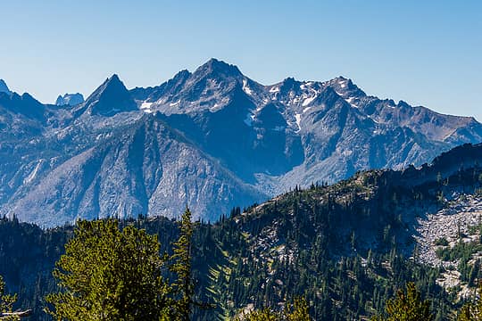
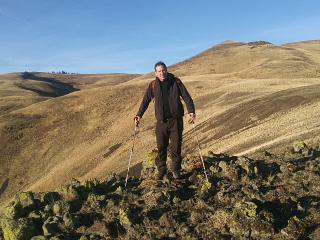
Hatchery creek trail starts immediately going up through the site of massive 2014 Chiwaukum creek fire. For miles there is no tree left unburned, however flowering fireweed makes the scenery livelier. It is very dusty and ashy, but the trail is very well maintained and fully logged out. In the morning I only met one hunter going up and one fisherman going down after spending the night, both early on the trail. Eventually (after about 6.5 miles) Hatchery creek trail ends at the junction with Icicle ridge trail. Confusingly Icicle ridge trail doesnt actually follow the ridge there and instead goes down to lake Augusta. I left the trail at the intersection and instead followed the broad ridge off-trail up to the Big Jim summit, tagging a few other high points along the way. The ridge is mostly open and sometimes scrambly and rocky, sometimes broad and an easy walk.
Finally I was out of the forest fire destruction and surrounded by much nicer alpine forest. No berries (yet?), but many-many mushrooms. The views to Cashmere mountain, lake Augusta and two Big Jim lakes are really good from the ridge. The trees are a mix of lodgepole pine and larch. This area will look spectacular once the larches turn golden in a month or so. I have never been to Colorado, but I read online that eastern Chiwaukums scenery remind people of it.
 Cashmere mountain 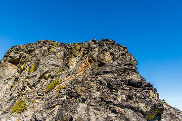 One of many scrambly high points on the ridge route 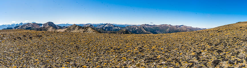 Broad ridge of Big Jim 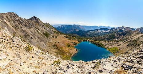 Lake Augusta 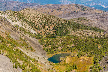 Big Jim lakes 1&2 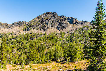 Big Lou 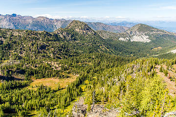 Minuscule Carter lake 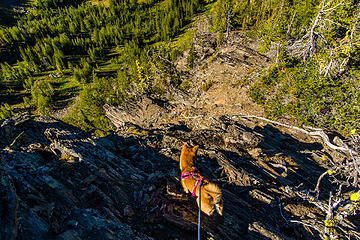 Typical terrain from Carter lake to Big Lou saddle and lake Ida 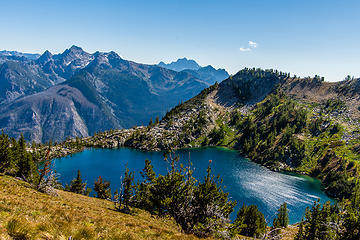 Lake Ida 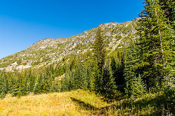 Painter creek valley 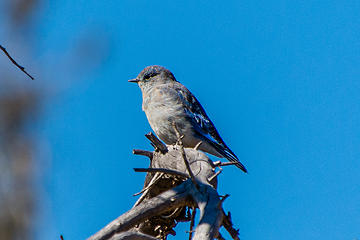 One of the many bluebirds 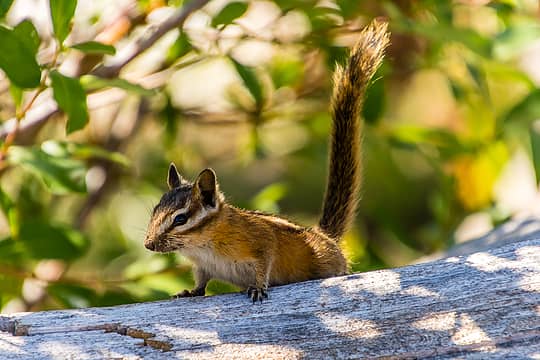 Little chipmunk 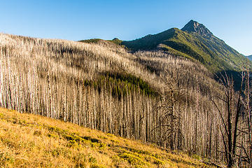 The badlands
|
| Back to top |
  
|
|
Brucester
Member
Joined: 02 Jun 2013
Posts: 1102 | TRs | Pics
Location: Greenwood |
Nice! Thanks for sharing!
Love how open it is!
Been on my list for awhile!!!
|
| Back to top |
|
|
kitya
Fortune Cookie
Joined: 15 Mar 2010
Posts: 842 | TRs | Pics
Location: Duvall, WA |
|
kitya
Fortune Cookie
|
Sun Sep 02, 2018 2:56 pm |
|
|
| Brucester wrote: | | Been on my list for awhile!!! |
Now is a good time. Chiwaukums are best avoided in summer, as they get immensely hot and have no shade. But once temperatures drop a little bit - they open and lovely. Very few people. But there is a price to pay - no approach is short and to get to the beautiful alpine country almost all trails include miles of hiking through burns. Burns can be depressing.
|
| Back to top |
|
|
Bootpathguy
Member

Joined: 18 Jun 2015
Posts: 1791 | TRs | Pics
Location: United States |
Question
Hatchery Creek Trailhead to Lake Augusta
What's your opinion on, if its a safe winter snowshoe. I was going to check it out this past winter and never got around to it.
I did drive by, and understand that the hike will start at hwy2, but I'm interested in the avalanche terrain to Lake Augusta Basin
Thanks
Experience is what'cha get, when you get what'cha don't want
Experience is what'cha get, when you get what'cha don't want
|
| Back to top |
|
|
Brushwork
Food truck
Joined: 18 Aug 2018
Posts: 508 | TRs | Pics
Location: Washington |
|
Brushwork
Food truck
|
Mon Sep 03, 2018 3:33 am |
|
|
Bootpath,
There's a fairly steep slope to drop down to reach basin below lake Augusta. I think it could be risky unless real stable snow conditions.
When I grow up I wanna play.
When I grow up I wanna play.
|
| Back to top |
|
|
kitya
Fortune Cookie
Joined: 15 Mar 2010
Posts: 842 | TRs | Pics
Location: Duvall, WA |
|
kitya
Fortune Cookie
|
Mon Sep 03, 2018 8:51 am |
|
|
| Bootpathguy wrote: | | What's your opinion on, if its a safe winter snowshoe. I was going to check it out this past winter and never got around to it. |
I never dropped to Lake Augusta, Bootpathguy, so I don't actually know. I always stayed on the ridge above Lake Augusta. I have not seen any signs of avy activity (no bend/broken trees, obvious gullies, etc.). However it is hard to be sure, because of how little vegetation there is. Maybe there is just not enough snow for serious avalanches there. Anyway, usual caution is obviously in order, but I would think it is definitely doable on a safe day, maybe like a spring snowshoe or early winter before too much snow. In fact, I'll probably consider this for a snowshoe myself one day, if I have time.
|
| Back to top |
|
|
Bootpathguy
Member
Joined: 18 Jun 2015
Posts: 1791 | TRs | Pics
Location: United States |
Thanks to both of you
Experience is what'cha get, when you get what'cha don't want
Experience is what'cha get, when you get what'cha don't want
|
| Back to top |
|
|
mbravenboer
Member
Joined: 20 Oct 2013
Posts: 1422 | TRs | Pics
Location: Seattle |
Nice trip again!
On one of my earlier snowshoe adventures I went to Pt 7053. I didn't have much experience at the time and thought that the climb up Hatchery was a bit steep on icy snow with snowshoes. These days I would probably use crampons on icy steep snow like that. Besides that steep part, the stroll to Pt 7053 is lovely rolling terrain without a sufficient angle for avalanches. I didn't go down to Lake Augusta.
https://www.nwhikers.net/forums/viewtopic.php?p=929032
It's kind of funny to read that again and see how attached I was to following a trail 
|
| Back to top |
|
|
Get Out and Go
Member

Joined: 13 Nov 2004
Posts: 2128 | TRs | Pics
Location: Leavenworth |
Thanks for the TR, kitya. Far too much time has passed since I've been up there. Hope to squeeze a trip in this year, yet. 
"These are the places you will find me hiding'...These are the places I will always go."
(Down in the Valley by The Head and The Heart)
"Sometimes you're happy. Sometimes you cry.
Half of me is ocean. Half of me is sky."
(Thanks, Tom Petty)
"These are the places you will find me hiding'...These are the places I will always go."
(Down in the Valley by The Head and The Heart)
"Sometimes you're happy. Sometimes you cry.
Half of me is ocean. Half of me is sky."
(Thanks, Tom Petty)
|
| Back to top |
|
|
Distel32
Member
Joined: 03 Jun 2014
Posts: 961 | TRs | Pics
Location: Edmonds, WA |
|
Distel32
Member
|
Mon Sep 03, 2018 9:53 pm |
|
|
|
| Back to top |
|
|
cascadetraverser
Member

Joined: 16 Sep 2007
Posts: 1407 | TRs | Pics
|
That is a great area and after tripping up there several times I have wondered about the state of those abandoned as well as recently burned, rarely used trails and really appreciate the update!
|
| Back to top |
|
|
Opus
Wannabe

Joined: 04 Mar 2006
Posts: 3700 | TRs | Pics
Location: The big rock candy mountain |
|
Opus
Wannabe
|
Tue Sep 04, 2018 7:05 pm |
|
|
I was out in the same are early August, but reached Ida from the Ladies Pass side bypassing Carter. I also didn't see a trail going up to Ida and ended up going over the backside of the ridge to intersect with the route up from Chatter Creek. Easy travel from Ida up to the top of Big Lou. A bit steep and loose but it's not bad descending from there to the junction with the trail above Augusta.
I dropped down to Big Jim Lakes from the ridge below Big Jim Mountain. The upper part is steep but not that hard. The lower half down to the lakes is more problematic. I tried following the creek on descenders left but that cliffs out. Going over past the brush to the right also gets unpleasant. One has to stay way to the right in large larch trees and boulders to get down easily. From lower Big Jim there is a pretty pleasant trail out to the Badlands trail highpoint, so getting to the lakes from Hatchery that is probably the best option. Easy to follow through the burn.
And then I stupidly descended the rest of the way down to Chiwaukum Creek via the Painter Creek trail. Head-high fireweed obscuring a burned trail and downed logs everywhere. I think it took multiple hours to go less than a mile. Not recommended. My legs were scarred for days.
|
| Back to top |
|
|
chiwakum
not credible

Joined: 29 Jun 2009
Posts: 980 | TRs | Pics
Location: Ballard |
|
chiwakum
not credible
|
Thu Sep 06, 2018 5:59 am |
|
|
Thanks for the report. I did a similar loop as backpack back in 2009 before the burn. I really enjoyed the Painter Ck and Badlands sections. Sad to hear how devestated it is now.
You really cover a lot of ground.
|
| Back to top |
|
|
kitya
Fortune Cookie
Joined: 15 Mar 2010
Posts: 842 | TRs | Pics
Location: Duvall, WA |
|
kitya
Fortune Cookie
|
Thu Sep 06, 2018 8:28 am |
|
|
| Opus wrote: | | And then I stupidly descended the rest of the way down to Chiwaukum Creek via the Painter Creek trail. Head-high fireweed obscuring a burned trail and downed logs everywhere. I think it took multiple hours to go less than a mile. Not recommended. My legs were scarred for days. |
Hi Opus, are you saying Painter Creek trail to Chiwaukum Creek trail is overgrown, or Chiwaukum trail itself? Please let me know, as I'm curious. Thank you!
|
| Back to top |
|
|
kitya
Fortune Cookie
Joined: 15 Mar 2010
Posts: 842 | TRs | Pics
Location: Duvall, WA |
|
kitya
Fortune Cookie
|
Thu Sep 06, 2018 8:30 am |
|
|
| chiwakum wrote: | | Thanks for the report. I did a similar loop as backpack back in 2009 before the burn. I really enjoyed the Painter Ck and Badlands sections. Sad to hear how devestated it is now. |
Hi Chiwakum. Great name  Painter Creek is overgrown trail, but not burned. Painter creek is very pretty. Badlands and Hatchery creek are devastated by the burn though - there is no single tree left alive. Painter Creek is overgrown trail, but not burned. Painter creek is very pretty. Badlands and Hatchery creek are devastated by the burn though - there is no single tree left alive.
|
| Back to top |
|
|
|
|


