| Previous :: Next Topic |
| Author |
Message |
Justus S.
Member


Joined: 17 Nov 2004
Posts: 1298 | TRs | Pics
Location: WA |
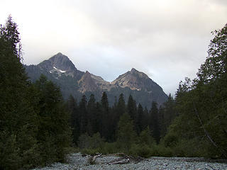
Peak 5630, A lovely pyramid shaped peak southwest of Silvertip Peak.
I had a wonderful Labor Day hike out of Monte Cristo. I started biking a little before 7am from Barlow Pass. A bike is essential equipment if going to Monte Cristo. I was a little confused where the road splits into two trails and accidentally found myself on the trail to Gothic Basin, but luckily there was a junction down to the trail to Monte Cristo. The river crossing is trivial with just a short carry on a nice log. Upon reaching the old town site I stashed my bike and headed up the trail to Silver Lake. The clouds began lifting as I neared the lake. There were several campers at the lake.
From the lake, I went up the climbers path to Silvertip. It's a very pretty hike up the ridge. I recommend going up this way if you are visiting the lake. I went all the way to the ridge crest at 6k. I now had a nice view of todays destination below. From here you have to loose 800ft then gain another 400ft to get to the summit. I dropped down the south side of the ridge a couple hundred feet then went over to the north side basin. I then made my way down to the nice, grassy saddle and then up to the summit.
I spent a nice hour or more on the summit enjoying the views and relaxing. I wondered what it must have been like for the miners who ventured up this peak a hundred years before. Perhaps they could look down on the buildings of Mineral City or hear/see the train chugging up the valley to Monte Cristo. All that is now gone. I was surprised to hear a dog bark while up here, but I think it came all the way over from Gothic Basin as there were lots of folks over there.
Nice hike, great day out.
Trip time: 1.5hrs biking and 11.5hrs hiking but I wasnt in a hurry. Blueberries are out in full force.
 Silvertip left, Peak 5630 from river crossing 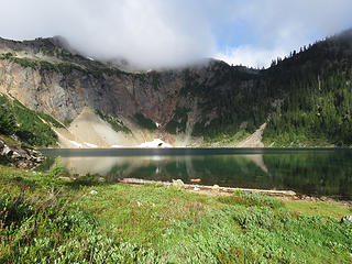 Silver Lake 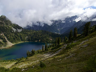 hiking up the ridge 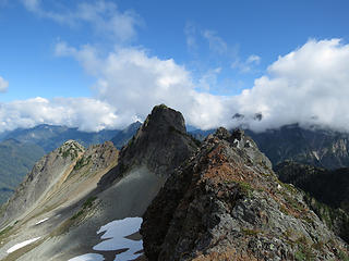 Silvertip 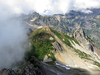 View down to summit pyramid 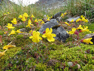 flowers 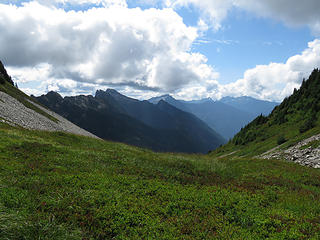 Grassy Saddle 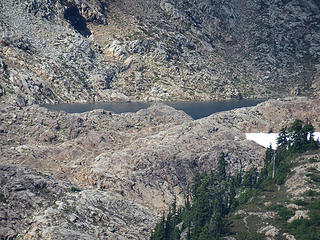 Gothic Basin 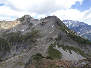 Silvertip 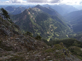 View down toward Mineral City 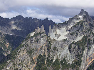 Wilmans
|
| Back to top |
  
|
|
FiresideChats
Member
Joined: 20 Jan 2014
Posts: 365 | TRs | Pics
Location: San Juan Islands |
Great pics!
I overnighted with the kids on the river outside of Monte Cristo and then we soaked in a Sunday morning climb up to Glacier Basin with those crystal clear skies. First time to Monte Cristo, but not the last.
|
| Back to top |
|
|
Schroder
Member

Joined: 26 Oct 2007
Posts: 6722 | TRs | Pics
Location: on the beach |
|
Schroder
Member
|
 Wed Sep 05, 2018 8:02 am |
|
|
Really nice photos, Justus.
That was one of my first hikes back in the early 60's and it remains one of my most favorite areas. There was a cat-track back then from Monte Cristo up to where you cross the creek below Poodledog Pass now and it was always muddy. I last hit that peak about 10 years ago in January trying to get over to Silvertip but the snow was too sketchy to traverse. It's a great little scramble. A couple of friends of mine did the first ascent from the North side.
|
| Back to top |
|
|
iron
Member

Joined: 10 Aug 2008
Posts: 6392 | TRs | Pics
Location: southeast kootenays |
|
iron
Member
|
Wed Sep 05, 2018 10:06 am |
|
|
cool. i have been wanting to do that peak for awhile.
|
| Back to top |
|
|
olderthanIusedtobe
Member
Joined: 05 Sep 2011
Posts: 7709 | TRs | Pics
Location: Shoreline |
Don't recall seeing a TR for this peak before, cool.  Interesting getting a view of Gothic Basin from a difference perspective.
The approach to Monte Cristo is totally mundane, but everything beyond there is cool Glacier Basin, Silver Lake, Twin Lakes. Interesting getting a view of Gothic Basin from a difference perspective.
The approach to Monte Cristo is totally mundane, but everything beyond there is cool Glacier Basin, Silver Lake, Twin Lakes.
|
| Back to top |
|
|
cartman
Member
Joined: 20 Feb 2007
Posts: 2800 | TRs | Pics
Location: Fremont |
|
cartman
Member
|
Wed Sep 05, 2018 3:27 pm |
|
|
Nice to see pics of a rarely mentioned peak.
This peak is called National on Lists of John.
Isn't there a new or different/rebuilt road to Monte Cristo from Barlow that doesn't require a river crossing on a log?
|
| Back to top |
|
|
Yana
Hater

Joined: 04 Jun 2004
Posts: 4212 | TRs | Pics
Location: Out Hating |
|
Yana
Hater
|
Wed Sep 05, 2018 5:16 pm |
|
|
National Peak is in Dave Fish's excellent Rambling and Scrambling book, though his approach is not via the Monte Cristo town site.
PLAY SAFE! SKI ONLY IN CLOCKWISE DIRECTION! LET'S ALL HAVE FUN TOGETHER!
PLAY SAFE! SKI ONLY IN CLOCKWISE DIRECTION! LET'S ALL HAVE FUN TOGETHER!
|
| Back to top |
|
|
Justus S.
Member
Joined: 17 Nov 2004
Posts: 1298 | TRs | Pics
Location: WA |
Thanks for the comments.
National Peak, hmm must be named after a mine?
Yeah, I don't own a copy of Dave's book.
This old photo show the pyramid shaped summit from gothic basin area.
http://www.historylink.org/File/8404
Schroder, nice climbing history. Winter time in the right conditions sounds like neat time to climb this via a direct approach.
Eric, there is a new road past the pass, but I've never taken it. The regular route from Barlow Pass is easy this time of year and probably shorter.
|
| Back to top |
|
|
neek
Member

Joined: 12 Sep 2011
Posts: 2337 | TRs | Pics
Location: Seattle, WA |
|
neek
Member
|
Thu Sep 06, 2018 8:42 am |
|
|
Nice to see the perspective from this point, which happens to be almost exactly between two peaks I have done in recent weeks, Columbia and Gothic.
| Justus S. wrote: | | Eric, there is a new road past the pass, but I've never taken it. The regular route from Barlow Pass is easy this time of year and probably shorter. |
Agreed - while the bypass road is in good condition, it's a mile longer and is somewhat of a roller coaster.
|
| Back to top |
|
|
tmatlack
Member
Joined: 21 Aug 2007
Posts: 2854 | TRs | Pics
|
|
tmatlack
Member
|
Thu Sep 06, 2018 11:04 pm |
|
|
I wonder if the brush-bash tread from Poodle Dog down to Galena on the Index side is still there? We did that back in the early 90's and it was faint but orange taped and tagged. That is the route Pearsall? Took to "discover" MC.
|
| Back to top |
|
|
daffish
Member

Joined: 16 Sep 2009
Posts: 282 | TRs | Pics
Location: Dreamtime |
|
daffish
Member
|
Tue Sep 11, 2018 8:17 pm |
|
|
Nice photos, Justus S.
It's good to see that peak get some attention.
That seldom climbed peak is a favorite of mine in the Monte Cristo area. I got the name from the 1977 book, "Monte Cristo Area, a Complete Outdoor Guide" by the great local historians, Harry M. Majors and Richard C. McCollum. The book has more complete history and information than the Becky guide for the entire Monte Cristo region. I have also climbed this peak from Weeden Pass on a fun traverse (also in my book).
"Be moderate in everything, including moderation" Horace Porter
"Be moderate in everything, including moderation" Horace Porter
|
| Back to top |
|
|
Chief Joseph
Member

Joined: 10 Nov 2007
Posts: 7707 | TRs | Pics
Location: Verlot-Priest Lake |
| cartman wrote: | | sn't there a new or different/rebuilt road to Monte Cristo from Barlow that doesn't require a river crossing on a log? |
Yes. If you go past Barlow pass about a mile, when you get to the first bridge, the trail begins just past it on the right. We hiked up it last year and met a couple guys on dirt bikes and a couple of FS Ranger trucks. We asked them if motorized vehicles were allowed and they said as far as they knew. A local Ranger was actually giving a tour to some out state Rangers (or maybe it was a review of the Federal cleanup?) At any rate they weren't concerned about the motorcycles. There is a gate though so cars and trucks won't fit.
Go placidly amid the noise and waste, and remember what comfort there may be in owning a piece thereof.
Go placidly amid the noise and waste, and remember what comfort there may be in owning a piece thereof.
|
| Back to top |
|
|
|
|


