| Previous :: Next Topic |
| Author |
Message |
raising3hikers
Member


Joined: 21 Sep 2007
Posts: 2344 | TRs | Pics
Location: Edmonds, Wa |
Booker Mtn 8280'
I started hiking at the Cascade Pass TH at 7:20am on Monday. It was cloudy and even a couple drops of rain fell on the way to the pass. The forecast called for improving conditions, so I was really hoping for that. As I made my way up Sahale Arm, I could see that there is a start to some of the fall colors while it looked like the clouds were trying hard to clear.
I reached the Sahale glacier camp area (7500') only to have to descend a long ways down to the upper Horseshoe basin. The access gully was melted out and it was steep dirt and rocks to the snow patch below. From there, I decided to drop down even further (5900') for a lower traverse over towards a buttress in front of Booker. Many small stream crossings in the choss zone had me going up and down for a while until I just dropped lower to the meadows. There were lots of blueberries to snack on along the way.
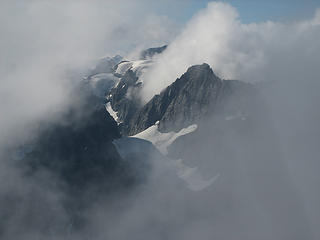 clouds putting up a fight 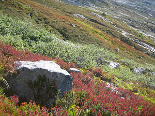 fall colors in Horseshoe basin 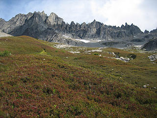 Ripsaw ridge 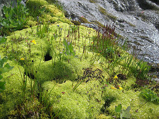 lots of green mosses near the water 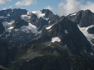 Spider, Hurry Up, Pelton and Magic 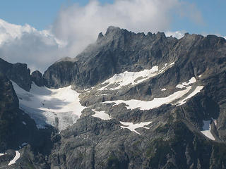 Mix-up pk 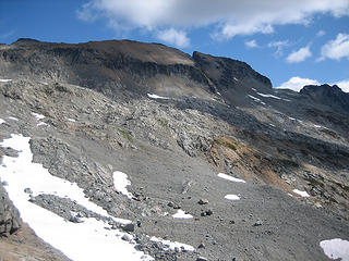 Booker Mtn 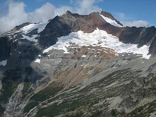 Sahale, Boston and the upper Horseshoe basin 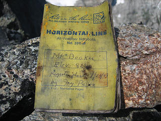 Booker register 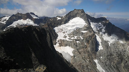 Buckner 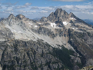 Storm King and Goode 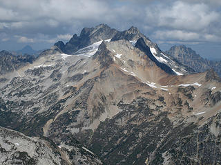 Logan 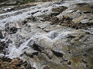 waterfalls and slabs 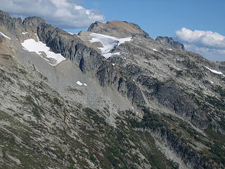 a look at Booker from below Sahale 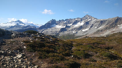 Eldorado to Forbidden 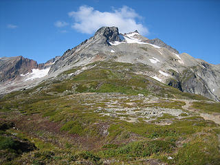 Sahale
|
| Back to top |
  
|
|
tommytownsend
Member

Joined: 28 Oct 2009
Posts: 44 | TRs | Pics
|
Another mellow day hike with Eric.
|
| Back to top |
|
|
iron
Member

Joined: 10 Aug 2008
Posts: 6392 | TRs | Pics
Location: southeast kootenays |
|
iron
Member
|
 Tue Sep 04, 2018 8:02 pm |
|
|
tired legs, sure. should've taken the shortcut route to save some miles.
sad looking glaciers out there. a decade or so left until they're gone...
|
| Back to top |
|
|
whoami
Probably Nobody
Joined: 27 May 2018
Posts: 16 | TRs | Pics
Location: Sedona, Arizona |
|
whoami
Probably Nobody
|
Tue Sep 04, 2018 8:17 pm |
|
|
I distinctly remember climbing this (also on a daytrip) with an old friend. We had a great time.
Looks like you are quickly ticking off the Top 200. Awesome work, Eric.
A ship is safe in harbor, but that's not what ships are for.
A ship is safe in harbor, but that's not what ships are for.
|
| Back to top |
|
|
puzzlr
Mid Fork Rocks

Joined: 13 Feb 2007
Posts: 7220 | TRs | Pics
Location: Stuck in the middle |
|
puzzlr
Mid Fork Rocks
|
Tue Sep 04, 2018 8:25 pm |
|
|
Thanks for the report. It's always fun to see where you choose to go. How do you pick?
|
| Back to top |
|
|
jdk610
Member

Joined: 21 Aug 2012
Posts: 330 | TRs | Pics
|
|
jdk610
Member
|
Tue Sep 04, 2018 8:34 pm |
|
|
|
| Back to top |
|
|
b00
Member

Joined: 29 Sep 2003
Posts: 1144 | TRs | Pics
|
|
b00
Member
|
Fri Sep 14, 2018 12:42 pm |
|
|
| raising3hikers wrote: | Ripsaw ridge |
love that area of upper horseshoe basin!
booker looks so fun! what great time you made in that rugged terrain. you pick such cool trips. so glad to hit the weather, smoke and time window so perfectly!
:>)
|
| Back to top |
|
|
cartman
Member
Joined: 20 Feb 2007
Posts: 2800 | TRs | Pics
Location: Fremont |
|
cartman
Member
|
Sun Sep 16, 2018 12:05 pm |
|
|
Another good one, and some nice color pics in there.
An alternative way into the basin that avoids the steep gully is to hike that same ridge all the way to its end and drop down and climber's right on steepish grassy slopes then at the base of the ridge turn left and go around the end into the basin. There are old rusted mining odds and ends here, including a lantern.
If Eric is confident in that 22 mile number, and Tom is confident in the 15 mile estimate, then someone is way off.
Matt has 18+ miles for Booker and Horseshoe here.
Eric, you sure about that 22 mile estimate?
|
| Back to top |
|
|
raising3hikers
Member
Joined: 21 Sep 2007
Posts: 2344 | TRs | Pics
Location: Edmonds, Wa |
| cartman wrote: | | If Eric is confident in that 22 mile number, and Tom is confident in the 15 mile estimate, then someone is way off. Matt has 18+ miles for Booker and Horseshoe here. Eric, you sure about that 22 mile estimate? |
Although I have a new GPS, I have tested it against other known distances and I haven't seen it to be off. Even on the Booker trip, I checked it at cascade pass and it was pretty much spot on at 3.5 miles from the TH. My wanderings down in Horseshoe basin wasn't as direct as it could have been because of many deep gullies in the way. It forced me to do many ups and downs that add up. I always try to be as accurate as I can to provide good information for others trying to plan a trip.
iron and Tom took a nice, big shortcut by shooting straight up to Sahale Arm from the last switchback, thus avoiding many trail miles. They also went in the big snow/late snow year where they could take nice and direct routes on snow.
|
| Back to top |
|
|
mike
Member

Joined: 09 Jul 2004
Posts: 6397 | TRs | Pics
Location: SJIsl |
|
mike
Member
|
Sun Sep 16, 2018 6:03 pm |
|
|
| raising3hikers wrote: | | Although I have a new GPS, I have tested it against other known distances and I haven't seen it to be off. |
I figure at least 10% off the top of a gps track for random roaming errors then take more off for minor side trips. YMMV
|
| Back to top |
|
|
Matt
Tea, Earl Grey, Hot

Joined: 30 Jan 2007
Posts: 4307 | TRs | Pics
Location: Shoreline |
|
Matt
Tea, Earl Grey, Hot
|
Mon Sep 17, 2018 9:23 pm |
|
|
I was surprised you found so few ascents in the register. I think Booker is a beautiful summit location.
As beacons mountains burned at evening. J.R.R. Tolkien
As beacons mountains burned at evening. J.R.R. Tolkien
|
| Back to top |
|
|
jupsal
Member
Joined: 20 Aug 2017
Posts: 49 | TRs | Pics
|
|
jupsal
Member
|
Thu Sep 27, 2018 10:00 am |
|
|
For what it's worth, I did this same trip yesterday and my GPS also said about 22 miles.
|
| Back to top |
|
|
DIYSteve
seeking hygge

Joined: 06 Mar 2007
Posts: 12655 | TRs | Pics
Location: here now |
|
DIYSteve
seeking hygge
|
Thu Sep 27, 2018 3:55 pm |
|
|
|
| Back to top |
|
|
Downhill
Member
Joined: 30 Jul 2018
Posts: 341 | TRs | Pics
Location: Leavenworth |
|
Downhill
Member
|
Fri Sep 28, 2018 3:59 pm |
|
|
Great trip report and beautiful photos - thanks for posting!
The photos of Ripsaw Ridge and HS basin bring back fond memories of a very panoramic bivy spent on the crest of Ripsaw en route to the N. Face of Buckner year ago. Thanks for refreshing that in my mind!
|
| Back to top |
|
|
|
|


