| Previous :: Next Topic |
| Author |
Message |
SultanHiker
Member


Joined: 04 Aug 2014
Posts: 78 | TRs | Pics
Location: Washington |
Thanks to Jacob Smith for the excellent beta. Absolutely precious. Big help.
And Mike Lewis for the GPX:
I mention Persindex frequently in this report. It is basically a halfway point between Persis and Index. It connects their two ridges. It is not a named peak on most maps. But peakbagger.com has its location. The tarns below it are a perfect place to grab water or to camp. Really a beautiful location.
Had wanted to do this for a long time. Road [FS 62] has been gated for a few years. Finally broke down and bought the Weyerhaeuser [Vehicle] Recreation Pass. Benefits include a gate key necessary for driving to the Persis trailhead. $250 for one year starting August 1st. May have bent the rules by bringing my friend Dave and his 2 kids [12ish and 14ish]. Shhhhh
😊
Started Labor Day Sunday. Kinda late [9:20 at Persis trailhead]. Was probably part of why we didnt complete the full mission. Last bit of road was rough for a Volvo XC70 wagon. Barely room to turn around and not much room for more than 2-3 cars near the trailhead. Earlier on the road in, we intercepted a threesome pushing bikes up with the intention of Persis trail maintenance. [[[I had planned on the previous Friday to do the same, but it was soaking wet drizzle that Friday morning, so I changed my mind and drove toward Haystack Mountain with two of my kids. Why that hill has a name at 2700ft? I dont know. Ten-Four is not named on maps [4400ft]
And it dwarfs haystack. I digress
]]]
Back to the real hike...
We wished the bikers luck and continued on.
Persis is a bushwhack for a good mile+. It seems to be getting some attention though. We met another party on the way back out who had put in some time cutting back the foliage. So its 20% better than before. Could use a hedge trimmer
PM me if you have one, and we can get working on that
Spent a little time on the Persis summit. Great weather and views. A sightseeing helicopter came out of nowhere on the east flank. Barely heard it right before it crested and dipped to the west flank. Then it came back around to the east and landed on a ridge west of Persindex. Looked like 3 people got out and the chopper shut down for about 45 minutes before they loaded up and took off.
--You may have to click the image after opening a photosphere to get it to go into 360 mode---
---PHOTOSPHERE---
---HELICOPTER VIDEO---
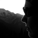
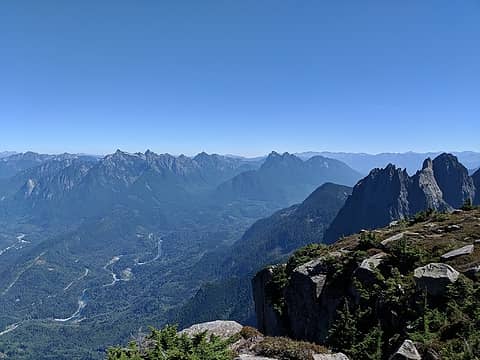 View to the east 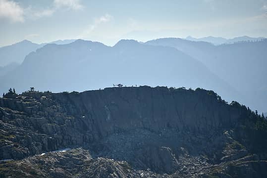 Helicopter landed on the ridge 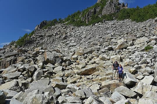 Talus below Persis 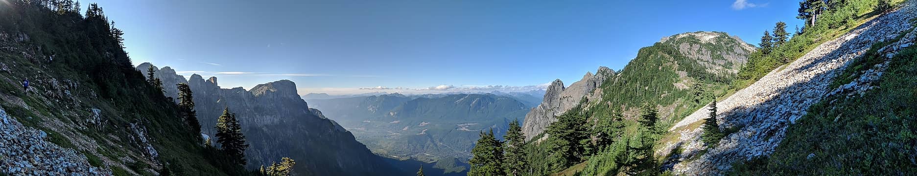 Persis on the left and Index on the right 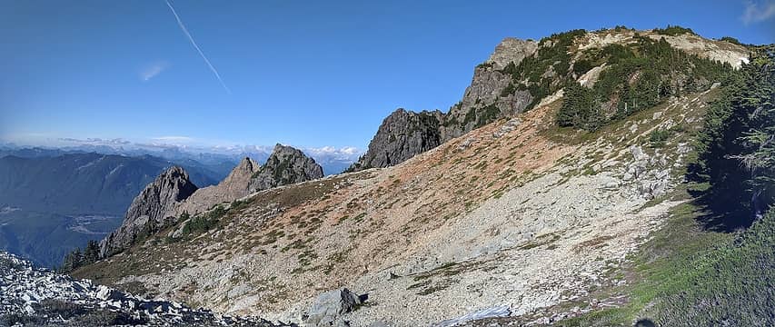 Index 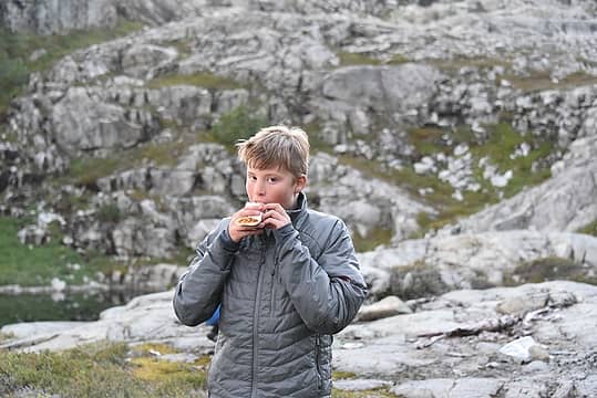 Trail burrito for dinner 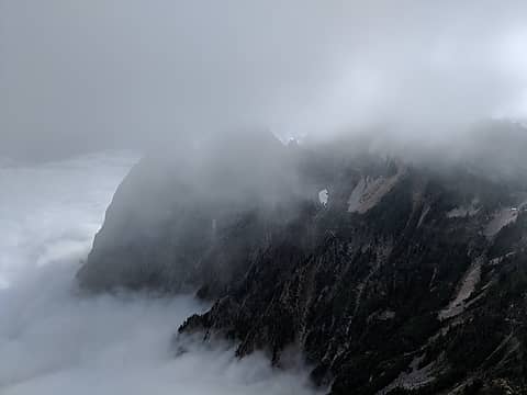 View of Index from Persindex
 healeyio healeyio
healeyio |
| Back to top |
  
|
|
RichP
Member

Joined: 13 Jul 2006
Posts: 5633 | TRs | Pics
Location: here |
|
RichP
Member
|
 Sat Sep 22, 2018 4:20 pm |
|
|
Good to see a report from that area.  I hope the permit price was worth it. I hope the permit price was worth it.
|
| Back to top |
|
|
Redwic
Unlisted Free Agent

Joined: 23 Feb 2009
Posts: 3292 | TRs | Pics
Location: Going to the Prom(inence) |
|
Redwic
Unlisted Free Agent
|
Sun Sep 23, 2018 3:19 pm |
|
|
Regarding the $250 permit... Does it only apply to the Forest Road 62 gate/area, of to other Weyerhaeuser areas in the State, as well?
60 pounds lighter but not 60 points brighter.
60 pounds lighter but not 60 points brighter.
|
| Back to top |
|
|
SultanHiker
Member
Joined: 04 Aug 2014
Posts: 78 | TRs | Pics
Location: Washington |
| Redwic wrote: | | Regarding the $250 permit... Does it only apply to the Forest Road 62 gate/area, of to other Weyerhaeuser areas in the State, as well? |
It gets access to some other areas as well. Here's the areas covered by the permit:
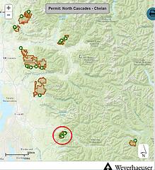 Red circle is FSRD-62
|
| Back to top |
|
|
LukerBee
Member

Joined: 13 Nov 2011
Posts: 102 | TRs | Pics
Location: Edmonds |
|
LukerBee
Member
|
Sun Sep 23, 2018 8:54 pm |
|
|
The one picture of the hike to Persis does not look much worse than years back. Good info about access.
He travels the fast who travels alone.
He travels the fast who travels alone.
|
| Back to top |
|
|
SultanHiker
Member
Joined: 04 Aug 2014
Posts: 78 | TRs | Pics
Location: Washington |
Here's another pic of the trail. Also not the worst of it. I don't pull out the camera when it's ultra thick. The worst is where the saplings have grown to 8 feet high and you're pushing the branches aside to verify your footing. Definitely makes it hard to follow the trail a half dozen times.
|
| Back to top |
|
|
SKS
Member

Joined: 16 Jun 2011
Posts: 161 | TRs | Pics
Location: Snohomish |
|
SKS
Member
|
Mon Sep 24, 2018 9:19 am |
|
|
Nice report! I've been looking at those mountains all summer wanting to go back there. I didn't realize so many people were still going up there.
|
| Back to top |
|
|
Gwen
LO Girl-of-the-Month
Joined: 14 Feb 2010
Posts: 1673 | TRs | Pics
|
|
Gwen
LO Girl-of-the-Month
|
Tue Sep 25, 2018 11:51 am |
|
|
| SultanHiker wrote: | | Haystack Mountain with two of my kids. Why that hill has a name at 2700ft? I dont know. Ten-Four is not named on maps [4400ft]
And it dwarfs haystack. I digress
]]] |
Prominence, maybe?
Tomorrow's not promised to anyone, so be bold, scare yourself, attempt something with no guarantee of success. You'll be amazed at what you can achieve. -Olive McGloin
Tomorrow's not promised to anyone, so be bold, scare yourself, attempt something with no guarantee of success. You'll be amazed at what you can achieve. -Olive McGloin
|
| Back to top |
|
|
SultanHiker
Member
Joined: 04 Aug 2014
Posts: 78 | TRs | Pics
Location: Washington |
| Gwen wrote: | | Prominence, maybe? |
Good idea. I looked it up. And Haystack ~500ft vs Ten-Four with ~2700. I think Haystack just looks like a haystack in shape from many angles. So the name stuck around enough to get on maps. Otherwise it's just a small hill attached to Ten-Four's NE flank.
|
| Back to top |
|
|
ale_capone
Member
Joined: 22 Sep 2009
Posts: 720 | TRs | Pics
|
thanks!
i saw the chopper from home and feared it was a rescue. couldnt find any news on it. didnt know that heli tours where a thing up there. hope they had wine and cheese.
i also highly agree regarding not taking a dog beyond persis. unless they are highly skilled, can rappel, and talus hop.
|
| Back to top |
|
|
Bluebird
suffering optional

Joined: 22 Jan 2014
Posts: 199 | TRs | Pics
Location: United States |
|
Bluebird
suffering optional
|
Mon Oct 01, 2018 7:34 pm |
|
|
It's great to see that the trail still exists. I used to do winter snowshoe trips to Persis when the road was open. It's a great snow summit, have never been in summer conditions. <3
|
| Back to top |
|
|
|
|


