| Previous :: Next Topic |
| Author |
Message |
GaliWalker
Have camera will use


Joined: 10 Dec 2007
Posts: 4930 | TRs | Pics
Location: Pittsburgh |
|
GaliWalker
Have camera will use
|
 Mon Nov 26, 2018 8:33 am |
|
|
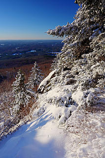
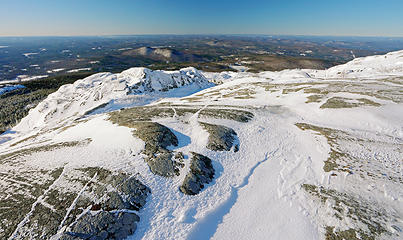
Mount Monadnock, New Hampshire (Nov 23, 2018)
Route: I took the White Dot Trail to the summit; retraced my steps from the summit to pick up the Smith Connecting Trail; continued down the Cliff Walk Trail; took a left on the Parker Trail to finish the loop.
The past few years our Thanksgiving break has been spent in New England, which has allowed me the opportunity to tuck in some hikes on the local mountains. Mt Monadnock, located in southern New Hampshire has become a favorite; it's located relatively close to our basecamp, has an expansive and quite beautiful summit area, and sports great 360° views. It's an extremely popular hiking spot though; not even the spicy conditions of late November deter the hardy New England crowds.
Since I had used the short and steep, but also the most popular, White Dot Trail to make my way up to the summit the past two times, I decided to switch things up this year by taking the much longer and lonelier Pumpelly Trail. Unfortunately, I was unable to find a good place to park near the trailhead, because the spots that should have been available were under deep snow. I ended up not taking the risk of leaving my car in a less than ideal spot beside the road and drove over to the substantial parking area for the White Dot Trail. I guess I would have to repeat the route I'd done twice before now.
Despite my later than anticipated arrival time of 6:45am I was the only person at the trailhead. The temperature was a frigid 5°F, but calm and still, so not too bad. There was a lot more snow and ice this year, due to a recent snowstorm, so I was forced to put on my microspikes right from the start, and they were essential footwear. The snow wasn't too much of an issue due to the well packed trail but the ice was thick and nearly impenetrable for the spikes.
After a relatively moderate climb for the first 0.8mi the grade steepened considerably, at times becoming a semi-scramble. Navigating the snow and ice coated granite boulders required care and attention. It was all worth it though as I broke out of the woods and gained the open amphitheater that led to the summit block lectern.
 1 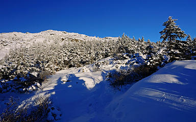 2 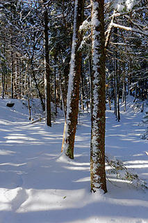 10 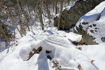 11 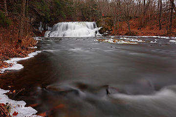 12 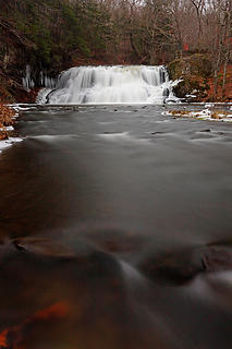 13
|
| Back to top |
  
|
|
Nancyann
Member

Joined: 28 Jul 2013
Posts: 2319 | TRs | Pics
Location: Sultan Basin |
|
Nancyann
Member
|
Mon Nov 26, 2018 3:51 pm |
|
|
Nice seeing a trip report from you, Gali. Those conditions seem so harsh, I cant imagine trying to take pictures, but yours look great!
|
| Back to top |
|
|
GaliWalker
Have camera will use
Joined: 10 Dec 2007
Posts: 4930 | TRs | Pics
Location: Pittsburgh |
|
GaliWalker
Have camera will use
|
Mon Nov 26, 2018 5:41 pm |
|
|
Thanks Nancy! Photography is really challenging, because the metal of the camera really sucks out all the heat from my hands, despite the thinner gloves that I slip into that make handling the camera buttons possible. I also have to take the camera battery out between pictures and keep it in a pocket where it can stay warm, otherwise its charge drains away.
 Brrr
|
| Back to top |
|
|
Nancyann
Member
Joined: 28 Jul 2013
Posts: 2319 | TRs | Pics
Location: Sultan Basin |
|
Nancyann
Member
|
Mon Nov 26, 2018 6:26 pm |
|
|
On really cold days I slip the batteries into my mitts which have hand warmers in them. That works well until they drop into the snow when I take the mitts off. 
|
| Back to top |
|
|
Layback
Cascades Expatriate

Joined: 16 Mar 2007
Posts: 5712 | TRs | Pics
Location: Back East |
|
Layback
Cascades Expatriate
|
Mon Nov 26, 2018 8:23 pm |
|
|
|
| Back to top |
|
|
Songs2
Member
Joined: 21 Mar 2016
Posts: 200 | TRs | Pics
|
|
Songs2
Member
|
Mon Nov 26, 2018 9:05 pm |
|
|
Thanks for these photos, GaliWalker!
That was the first mountain I ever climbed. It remained a favorite for years - a workout, with a couple of rugged spots. Some brilliant fall days I saw no one else on the trails, and only a couple of cars in an unattended lot.
In the 1950s there was a food stand on top.
I always enjoy your photos, though "I am gobsmacked" would be a more accurate way of putting it.
|
| Back to top |
|
|
GaliWalker
Have camera will use
Joined: 10 Dec 2007
Posts: 4930 | TRs | Pics
Location: Pittsburgh |
|
GaliWalker
Have camera will use
|
Tue Nov 27, 2018 7:31 am |
|
|
| Songs2 wrote: | | In the 1950s there was a food stand on top. |

|
| Back to top |
|
|
Foist
Sultan of Sweat

Joined: 08 May 2006
Posts: 3974 | TRs | Pics
Location: Back! |
|
Foist
Sultan of Sweat
|
Tue Nov 27, 2018 4:15 pm |
|
|
Is Moosilauke too far? That was my favorite New Hampshire peak.
|
| Back to top |
|
|
Songs2
Member
Joined: 21 Mar 2016
Posts: 200 | TRs | Pics
|
|
Songs2
Member
|
Tue Nov 27, 2018 4:39 pm |
|
|
@GaliWalker: Sure! Wouldn't want to be hungry! I imagine it was among the last gasp of domesticating mountaintops with built structures such as hotels. That was definitely a thing; Mt Washington still has "Sheep Meadows" (no sheep, tho). I expect if one knew where to look on Monadnock, one might find holes drilled into the rock where the food shack was anchored.
@Foist: I've never been to Moosilauke, through drove by an access road whilst cutting a diagonal from White Mntns to Tanglewood. I am unsure of the distance between Monadnock and Moosilauke. Because older New England roads followed cow paths and animal trails and mysterious cart trails, which typically had no particular destination in mind, it could take a while to get from trailhead to trailhead. Sure is pretty country.
|
| Back to top |
|
|
GaliWalker
Have camera will use
Joined: 10 Dec 2007
Posts: 4930 | TRs | Pics
Location: Pittsburgh |
|
GaliWalker
Have camera will use
|
Tue Nov 27, 2018 5:29 pm |
|
|
| Foist wrote: | | Is Moosilauke too far? |
Yeah, that would've been twice the distance for me, and I needed to be back by lunchtime. I'm going to keep that one in mind for later though, just not around the Thanksgiving break.
|
| Back to top |
|
|
Foist
Sultan of Sweat
Joined: 08 May 2006
Posts: 3974 | TRs | Pics
Location: Back! |
|
Foist
Sultan of Sweat
|
Tue Nov 27, 2018 7:03 pm |
|
|
|
| Back to top |
|
|
GaliWalker
Have camera will use
Joined: 10 Dec 2007
Posts: 4930 | TRs | Pics
Location: Pittsburgh |
|
GaliWalker
Have camera will use
|
Tue Nov 27, 2018 7:34 pm |
|
|
 I have to say that I haven't hiked in New Hampshire since, except over Thanksgiving, because I discovered the Adirondacks, which are even cooler.
|
| Back to top |
|
|
nordique
Member

Joined: 04 May 2008
Posts: 1086 | TRs | Pics
|
|
nordique
Member
|
Sat Dec 01, 2018 8:05 pm |
|
|
I grew up in New England and did a lot of hiking and climbing while in college in Western Mass. The last time I did Monadnock, it was in hunting season, and we ran into two hunters, sitting on their 24-pack beer containers, resting. I asked if they'd seen any 'game,' and they said no, but they gotten off a few 'sound shots.' I asked what those were and they said they fired in the direction of what sounded like deer. I decided then and there to turn around and head back to to the trailhead, ASAP! And that was before I was wounded in Vietnam....
|
| Back to top |
|
|
joker
seeker

Joined: 12 Aug 2006
Posts: 7953 | TRs | Pics
Location: state of confusion |
|
joker
seeker
|
Sat Dec 01, 2018 11:13 pm |
|
|
Ahh your report reminds me of many cold hiking days in NH. Ten below was not uncommon as a daily high...
Have you been up around Bondcliff and Guyot and South Twin? It's a nice area IMHO. I assume you've done the Presidential range and the Franconias. some of the other 4,000 foot mountains are quite nice. Passaconway and Whiteface, the Carter range, the stuff over by Mahousic notch, etc... Some are utterly boring.
|
| Back to top |
|
|
Foist
Sultan of Sweat
Joined: 08 May 2006
Posts: 3974 | TRs | Pics
Location: Back! |
|
Foist
Sultan of Sweat
|
Sat Dec 01, 2018 11:50 pm |
|
|
I did all those in myboston days. Except mahousic notch, that one doesn't ring a bell.
|
| Back to top |
|
|
|
|


