| Previous :: Next Topic |
| Author |
Message |
Nancyann
Member


Joined: 28 Jul 2013
Posts: 2318 | TRs | Pics
Location: Sultan Basin |
|
Nancyann
Member
|
 Wed Jan 16, 2019 2:05 pm |
|
|
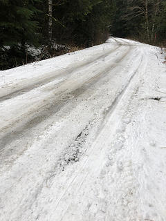
On Monday, Triciaann and I decided to see how far up the Foss River Road we could drive. We made it as far as the intersection with F.S. Road 6530. We had no interest in ruining our day by getting stuck, so we parked here and commenced the usual winter roadwalk.
There were signs that some people had used chains, and the potholes were as huge as I have ever seen, but the road appeared driveable with AWD or 4WD up to
the Necklace Valley trailhead, and there was an Audi and a Subie in the parking lot.
 Foss River Road 1/15/19 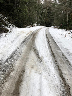 Foss River Road 1/15/19 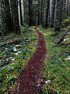 Necklace Valley Trail 1/15/19 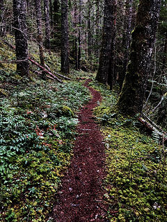 Necklace Valley Trail 1/15/19 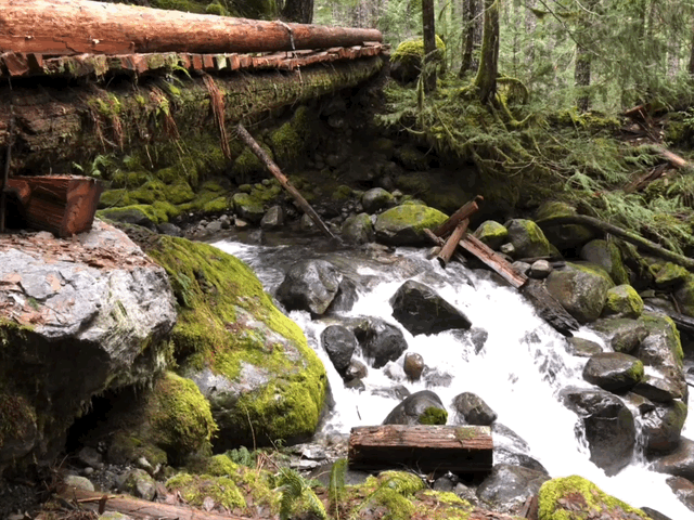 Necklace Valley Trail 1/15/19 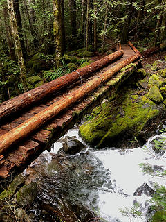 Necklace Valley Trail 1/15/19 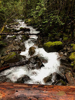 Necklace Valley Trail 1/15/19  Necklace Valley Trail 1/15/19 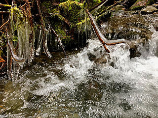 Necklace Valley Trail 1/15/19 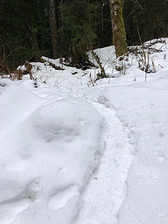 Necklace Valley Trail 1/15/19 
|
| Back to top |
  
|
|
Anne Elk
BrontosaurusTheorist

Joined: 07 Sep 2018
Posts: 2419 | TRs | Pics
Location: Seattle |
|
Anne Elk
BrontosaurusTheorist
|
Wed Jan 16, 2019 2:20 pm |
|
|
Love the two photos from the creek-level perspetive, Nancy Ann. Great composition. 
"There are yahoos out there. Its why we cant have nice things." - Tom Mahood
"There are yahoos out there. Its why we cant have nice things." - Tom Mahood
|
| Back to top |
|
|
Mikey
Member
Joined: 04 Sep 2003
Posts: 737 | TRs | Pics
Location: SW Washington |
|
Mikey
Member
|
Wed Jan 16, 2019 4:40 pm |
|
|
Great report and photos. I see the Necklace Valley Trailhead is shown as being at 1,670 feet altitude and your photos show snow at the trailhead. What altitude does the snow along the road begin?
|
| Back to top |
|
|
Chief Joseph
Member

Joined: 10 Nov 2007
Posts: 7703 | TRs | Pics
Location: Verlot-Priest Lake |
Nice, so jealous! The Necklace Valley is definitely on my "bucket list".
Go placidly amid the noise and waste, and remember what comfort there may be in owning a piece thereof.
Go placidly amid the noise and waste, and remember what comfort there may be in owning a piece thereof.
|
| Back to top |
|
|
RichP
Member

Joined: 13 Jul 2006
Posts: 5634 | TRs | Pics
Location: here |
|
RichP
Member
|
Wed Jan 16, 2019 5:36 pm |
|
|
Neat pics, Nancyann. Looks wintry too.
|
| Back to top |
|
|
Nancyann
Member
Joined: 28 Jul 2013
Posts: 2318 | TRs | Pics
Location: Sultan Basin |
|
Nancyann
Member
|
Wed Jan 16, 2019 5:42 pm |
|
|
Mikey, currently the snow on the road is intermittent at about 1500 feet, but that should change with the arrival of the next weather system.
CJ, I hope you are feeling better and will be able to get up there this year!
Thank you, Anne Elk, I feel like this creek is photogenic, especially with the nice-looking bridge. The East Fork Foss itself is very photogenic as well, thanks to its blue-green color, but the trail doesnt drop down to it until a little further up.
Thanks Rich, youre not missing that green moss are you?
|
| Back to top |
|
|
RichP
Member
Joined: 13 Jul 2006
Posts: 5634 | TRs | Pics
Location: here |
|
RichP
Member
|
Wed Jan 16, 2019 6:03 pm |
|
|
| Nancyann wrote: | | Thanks Rich, youre not missing that green moss are you? |
Yes, I am!
|
| Back to top |
|
|
zephyr
aka friendly hiker

Joined: 21 Jun 2009
Posts: 3370 | TRs | Pics
Location: West Seattle |
|
zephyr
aka friendly hiker
|
Wed Jan 16, 2019 7:33 pm |
|
|
| Nancyann wrote: | Necklace Valley Trail 1/15/19 |
Okay. How on earth did you do this? This is something like a gif, but different. Pretty fancy stuff there. ~z
|
| Back to top |
|
|
Nancyann
Member
Joined: 28 Jul 2013
Posts: 2318 | TRs | Pics
Location: Sultan Basin |
|
Nancyann
Member
|
Wed Jan 16, 2019 8:59 pm |
|
|
Its a fun phone app that I finally figured out how to use. 
|
| Back to top |
|
|
OutOfOffice
Member

Joined: 02 Jun 2015
Posts: 91 | TRs | Pics
Location: Seattle |
|
| Back to top |
|
|
timberghost
Member
Joined: 06 Dec 2011
Posts: 1328 | TRs | Pics
|
Awesome write up thanks for posting
|
| Back to top |
|
|
Mikey
Member
Joined: 04 Sep 2003
Posts: 737 | TRs | Pics
Location: SW Washington |
|
Mikey
Member
|
Fri Jan 18, 2019 2:14 pm |
|
|
There is a WTA trip report of 2 guys who hiked fast (ran ?) up Necklace Valley and climbed 7428 ft Mt Hinman. in one day (July 15, 2015). A more detailed report of their one day hike is here. Years ago I climbed 7178 ft Bears Breast which we accessed via the Middle Fork Snoqualmie river trail and since then have intended to hike the Necklace Valley trail.
|
| Back to top |
|
|
moonspots
Happy Curmudgeon

Joined: 03 Feb 2007
Posts: 2456 | TRs | Pics
Location: North Dakota |
|
moonspots
Happy Curmudgeon
|
Sat Jan 19, 2019 7:13 am |
|
|
Yup, that looks like it was a perfect day for a mind-clearing walk, for sure. I love walking through the forest(s) in this kind of weather.
And this one is particularly interesting, I think.
Watch the relationship between the rocks at the right edge of the pic comparing their (apparent) non-movement to the edge of the pic, then look at the bottom and watch the bridge as it appears to move back and forth maybe an inch or so, according to camera movement when the short clip was taken.
And I agree, not ruining the day by getting stuck was a fine bit of wisdom!
"Out, OUT you demons of Stupidity"! - St Dogbert, patron Saint of Technology
"Out, OUT you demons of Stupidity"! - St Dogbert, patron Saint of Technology
|
| Back to top |
|
|
zephyr
aka friendly hiker
Joined: 21 Jun 2009
Posts: 3370 | TRs | Pics
Location: West Seattle |
|
zephyr
aka friendly hiker
|
Sat Jan 19, 2019 11:33 am |
|
|
| moonspots wrote: | | watch the bridge as it appears to move |
"appears"? Obviously that bridge is breathing. Remember what the O.P. said:
| Nancyann wrote: | | Burn Creek was very pretty and the bridge across it looked like it had been upgraded recently. |
That's one of those high end models. ~z
|
| Back to top |
|
|
Nancyann
Member
Joined: 28 Jul 2013
Posts: 2318 | TRs | Pics
Location: Sultan Basin |
|
Nancyann
Member
|
Sat Jan 19, 2019 12:01 pm |
|
|
I was having a little fun with a phone app in the moving bridge picture, but I also find that I still enjoy using my trusty little cheap Nikon Coolpix camera depending on what I am photographing.
Does anyone know if it was volunteers who did the nice bridgework?
|
| Back to top |
|
|
|
|


