| Previous :: Next Topic |
| Author |
Message |
kitya
Fortune Cookie


Joined: 15 Mar 2010
Posts: 842 | TRs | Pics
Location: Duvall, WA |
|
kitya
Fortune Cookie
|
 Wed Mar 13, 2019 7:47 am |
|
|
Central cascades just west of Stevens Pass is a very pretty area and very close to my home, so I love going there. Last Saturday I decided to attempt K9, a mid-elevation mountain I have seen from PCT before. We started at Surprise Lake trailhead in the morning. There was maybe an inch of fresh snow in the parking area behind the railroad tracks, but the parking area was plowed before, so it was fine. I put on snowshoes right away from the car and was immediately surprised by the amount of different human trails in the forest. This area is popular! Appears some people went to Surprise Lake, some people to Scenic Hot Springs, and some people skinned before me to Hamada lake and many other trails I dont know where. The snow was very soft and fluffy, with large icicles, but great trail made by what appears a large group of skiers a day or so before made approach to Hamada Lake really fast and easy.
On the other side of the Hamada lake the skiers trail continued on the steep, but forested north-west slope of K9. I knew this is not the approach I was thinking of taking, but the trail was so nice and easy to follow, I just couldnt resist. I thought maybe skiers know something I dont. So I followed it all the way to the 5700 ft notch just below the impressive summit made out of completely impassable cliffs from that side. It appears skiers just went to the notch and skied back down from there. Tricksters they are!
Leaving the skiers trail we traversed slightly down to an open avalanche basin at about 5000 ft. From there I could see an open gully up all the way to another notch and a nice ridge to the summit, but it was very steep. We walked to only about 5200 ft and I felt sliding in deep powder snow and chickened out. From the basin it looked like the summit ridge is all cliffs where the trees are. So we went all the way back down to Hamada lake at 4200 gain. From Hamada lake I noticed another single ski track, this time to Murphy Lakes basin and decided to follow it. It was not as easy to follow as the previous trail, since snow was so soft I was still falling in deep into it on snowshoes, even on the skiers trail. But the trail was nice and safe to about 5300 ft. At 5300 ft there is a short, but really steep angle traverse just below open cliffs and even though there are some trees around, there is also a small gully to cross. I stopped there due to being somewhat scared and while I was contemplating a chance of avalanche and if I should take my ice axe out, a saw a bunch of snow falling onto me through the trees. Turns out it was the lonely skier who made the track skiing down. He encouraged me to continue, explaining that the exposed traverse is short and it all becomes much better after that. And indeed it did become much better. Finally we got to 5600 ft notch and realized that the lone skiers also didnt go to the summit of K9. Tricked me again 😊
Anyway, the path to K9 was actually finally obvious ridge path, with reasonable grade, albeit still long away. It also started snowing and due to all going up and down I was pretty exhausted, hungry and cold. So I decided to walk up to a little unnamed bump right next to the notch (elevation 5999 ft) and enjoy the snowy views from there instead. It was very beautiful with the Slippery Slab tower, Thunder Mountain, Thor and Nimbus right in the view. Very nice place!
https://connect.garmin.com/modern/activity/3449223803
P.S. The next day I thought to snowshoe up something extremely small, so that for sure I can make it, and it was tricky too. I went to Natapoc mountain, but the north approach described on wta is problematic due to private property. State road has multiple 'no parking along the roadway' signs and once it turns to gravel it is marked with the big 'private property, no entry except nason view residents' sign. There are many newly build million dollar looking custom homes. The trailhead and national forest road described by wta (nf-810) also have multiple 'private property', 'keep off' and 'nason view residents only' signs.
|
| Back to top |
  
|
|
neek
Member

Joined: 12 Sep 2011
Posts: 2336 | TRs | Pics
Location: Seattle, WA |
|
neek
Member
|
Wed Mar 13, 2019 8:41 am |
|
|
Lovely! Despite the title, seems like a success to me. Bummer about Natapoc. I wonder if the thing to do is just walk from Coles Corner.
|
| Back to top |
|
|
kitya
Fortune Cookie
Joined: 15 Mar 2010
Posts: 842 | TRs | Pics
Location: Duvall, WA |
|
kitya
Fortune Cookie
|
Wed Mar 13, 2019 10:11 am |
|
|
| neek wrote: | | Lovely! Despite the title, seems like a success to me. Bummer about Natapoc. I wonder if the thing to do is just walk from Coles Corner. |
Well, I didn't reach the summit of K9, but I did get to some other smaller unnamed summit and it was still very pretty with lots of views, so I'm not complaining.
If you think about the other road from Coles Corner to the North Approach trailhead (nf-810), the other road (snowshoe lane) is also marked as 'private, no entry' and the trailhead itself (nf-810 road) has a 'private keep out' sign. I think it is a shame private property encroaches on the forest and mountain access, especially in the area like natapoc where all these million dollar new custom homes are exposed to forest fires  I have not tried accessing Natapoc from the other side described on wta (River road), because I assume that side is probably not plowed for winter and it is much longer drive, but maybe that side still has no houses yet. I have not tried accessing Natapoc from the other side described on wta (River road), because I assume that side is probably not plowed for winter and it is much longer drive, but maybe that side still has no houses yet.
|
| Back to top |
|
|
neek
Member
Joined: 12 Sep 2011
Posts: 2336 | TRs | Pics
Location: Seattle, WA |
|
neek
Member
|
Wed Mar 13, 2019 11:20 am |
|
|
And Rieche Rd, or at least following the trail under the power lines? Worst case you're looking at a 1km walk along 207. Looks like a decent winter peak, I may have to check it out.
|
| Back to top |
|
|
kitya
Fortune Cookie
Joined: 15 Mar 2010
Posts: 842 | TRs | Pics
Location: Duvall, WA |
|
kitya
Fortune Cookie
|
Wed Mar 13, 2019 12:38 pm |
|
|
| neek wrote: | | And Rieche Rd, or at least following the trail under the power lines? Worst case you're looking at a 1km walk along 207. Looks like a decent winter peak, I may have to check it out. |
I think Reiche Road is the one turning to Snowshoe lane (marked as private). You can definitely try. Just to make this clear - I did go to Natapoc mountain anyway and I didn't see any people, so nobody actually stopped me from going. My biggest concern was where to leave the car, as I didn't want to leave my car on somebody's private property. So I left it on the state road, about a mile before private road through 'Nason view' community and nobody harassed me or my car or asked me to leave. It is a nice mountain with actually pretty views, just not panoramic.
|
| Back to top |
|
|
Nancyann
Member

Joined: 28 Jul 2013
Posts: 2316 | TRs | Pics
Location: Sultan Basin |
|
Nancyann
Member
|
Wed Mar 13, 2019 9:10 pm |
|
|
Thanks for the interesting and informative trip report, Kitya. I have really enjoyed looking at all the beautiful snowy pictures of one of my favorite areas that I usually only see in the summertime!
|
| Back to top |
|
|
puzzlr
Mid Fork Rocks

Joined: 13 Feb 2007
Posts: 7220 | TRs | Pics
Location: Stuck in the middle |
|
puzzlr
Mid Fork Rocks
|
Thu Mar 14, 2019 6:48 pm |
|
|
Your photos really show the deep snow higher up near the crest. Thanks for the report. Sets my expectations for getting out tomorrow.
RichP and I climbed Natapoc a couple years ago in January starting from River Rd. I don't know the area but it seems like a major road that would be plowed. And there was a plowed out parking area used by snowmobiles based on the tracks.
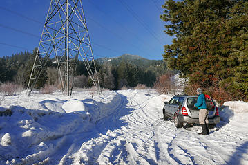 Parking spot under the power lines
|
| Back to top |
|
|
|
|
You cannot post new topics in this forum
You cannot reply to topics in this forum
You cannot edit your posts in this forum
You cannot delete your posts in this forum
You cannot vote in polls in this forum
|
Disclosure: As an Amazon Associate NWHikers.net earns from qualifying purchases when you use our link(s). |


