| Previous :: Next Topic |
| Author |
Message |
Eaglecadd
Member


Joined: 05 Feb 2010
Posts: 185 | TRs | Pics
Location: Kailua Kona, HI |
Just wondering if anyone has pics of the upper most part of Milk Creek Valley. I would like to see about planning a route, if possible, over to Deception Basin. I am not at all sure this is possible safely for a backpacker who is NOT a climber. If anyone has done this, is it possible to get some GRAPHIC route info...I am a very visual guy and it is hard for me to understand it if it is just verbal. Thank you for your help.
|
| Back to top |
  
|
|
meck
Member

Joined: 31 Dec 2010
Posts: 920 | TRs | Pics
|
|
meck
Member
|
 Tue Apr 09, 2019 7:48 pm |
|
|
I'll see if I can upload some photos and send you PM. I'm not really a climber and I've come down it from Fricaba several times as part of a loop day hike (Upper Dungy-Royal basin-Deception basin-Fricaba-Milk Creek drainage-cross the Dungy and then exit via Heather Creek/Upper Dungy trail). There are a few spots that are very, very steep that could be challenging to go over w/ hard snow pack as I recall.
*Just say NO to Rent-Seeking, don't give up the concept of "ownership"*
*Just say NO to Rent-Seeking, don't give up the concept of "ownership"*
|
| Back to top |
|
|
OlympicMtnHiker
Member

Joined: 29 Jan 2008
Posts: 21 | TRs | Pics
Location: Poulsbo, WA |
Milk Creek basin has been on my list of places to go for years now, but I still haven't made it over there yet. But it looks very wild and remote.
These photos that I took of Milk Creek basin in 2007 while on the shoulder of Petunia Peak were what inspired me to add the area to my list:
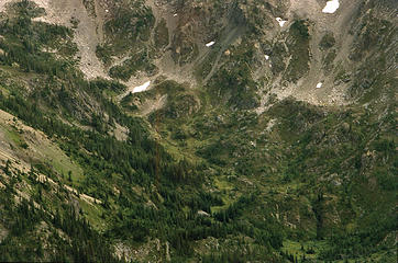 Milk Creek Basin With Waterfall- 2007 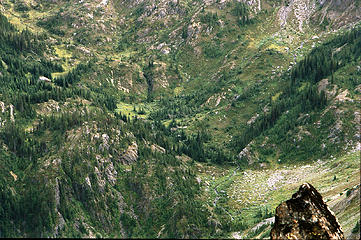 Milk Creek Basin With Waterfall- 2007 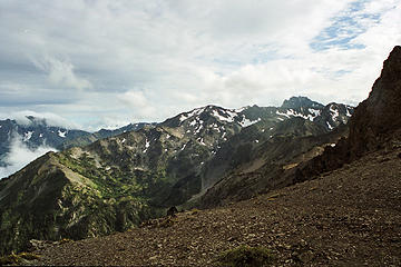 Milk Creek Basin From near Petunia Peak 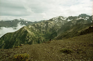 Milk Creek Basin From near Petunia Peak 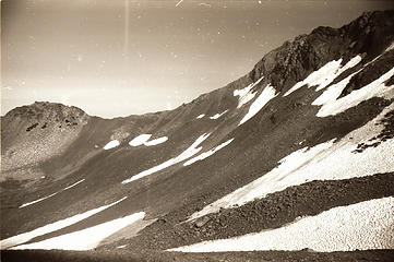 Ridge dividing upper Royal Basin from Upper Milk Creek basin 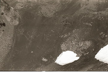 Zoomed in view of the lowest point of the saddle (about 6560ft) in the ridge shown in the previous photo 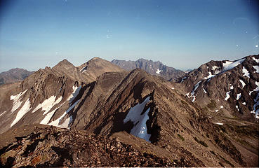 View looking east toward Fricaba from the (nearly) 7000ft 'peak' a little East of Snifter Spire on the divide between Royal Basin and Deception Basin. 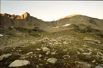 Mt. Fricaba from Deception Basin
|
| Back to top |
|
|
Eaglecadd
Member
Joined: 05 Feb 2010
Posts: 185 | TRs | Pics
Location: Kailua Kona, HI |
Thanks for the GREAT pics. It really helps me to try to make this a great and safer route. I know there will be many challenges to find a way through here and I want to do it in a safe manner. One of my concerns is crossing the ridge on the North side of Deception Basin toward Royal Basin. Has anyone done it? If so, where?
|
| Back to top |
|
|
meck
Member
Joined: 31 Dec 2010
Posts: 920 | TRs | Pics
|
|
meck
Member
|
Fri Apr 12, 2019 5:47 pm |
|
|
There should be a pretty obvious scree path up out of Deception Basin to the low pass just east of Mt Deception, that then drops into Royal Basin (I've gone up over this north->south twice over to Fricabe, and south to north once from climbing Hal Foss). The scree could be tedious (three steps forward, 1-2 steps back).
The Royal Basin side is very steep towards the top of the pass, and depending on snow conditions, could be quite dangerous. The exposed shale slopes in mid summer allowed me to stay slightly east of the pass on the Royal Basin side above the hard snow mini bowl on two occasions, but another time I went over it the snow was quite soft and I was able to boot-up the bowl (even the steep section approaching the top).
*Just say NO to Rent-Seeking, don't give up the concept of "ownership"*
*Just say NO to Rent-Seeking, don't give up the concept of "ownership"*
|
| Back to top |
|
|
Jake Robinson
Member
Joined: 02 Aug 2016
Posts: 521 | TRs | Pics
|
| Eaglecadd wrote: | | One of my concerns is crossing the ridge on the North side of Deception Basin toward Royal Basin. Has anyone done it? If so, where? |
Deception Basin to Royal Basin is pretty doable. There are several saddles to choose from - we crossed the 6800'+ saddle NW of Mt. Fricaba (the one just to the left of '6600' on the USGS map). There's some permanent snow on the N side of that saddle that's kind of steep. I believe we used ice axes for a few hundred feet. The S side is straightforward scree sidehilling and following faint animal/boot paths into Deception Basin. On the way back we used a different saddle closer to Mt. Deception and it was a lot steeper and more tedious.
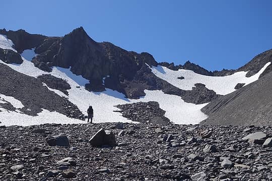 The N side of the saddle in September. 6800'+ saddle is on the right side of the photo.
|
| Back to top |
|
|
Eaglecadd
Member
Joined: 05 Feb 2010
Posts: 185 | TRs | Pics
Location: Kailua Kona, HI |
Thank you Jake. I appreciate the info and pic.
|
| Back to top |
|
|
|
|


