| Previous :: Next Topic |
| Author |
Message |
Dr. Evil
Member


Joined: 03 Apr 2006
Posts: 36 | TRs | Pics
Location: Woodinville |
|
Dr. Evil
Member
|
 Mon Jun 25, 2018 11:24 am |
|
|
Nice Sunday. I've never been to Rainy Lake. Very nice. My Topo App says it's 4 miles from parking lot to Lake. It seemed farther. Is this an accurate distance measurement? Also, I know there is a tarn up higher that I'm thinking might be a very cool place to spend the night. Is the route straight up the rockpile at end of lake? Ditto for route to top of Preacher?
 Rainy Lake  Rainy map
|
| Back to top |
  
|
|
DadFly
Member
Joined: 02 Jul 2012
Posts: 402 | TRs | Pics
Location: Redmond |
|
DadFly
Member
|
Mon Jun 25, 2018 2:53 pm |
|
|
The grid of light gray lines are 1 mile X 1 mile.
So "as the crow flies" the hike is 4 miles.
Add in all the switchbacks and angles and it is closer to 5.
"May you live in interesting times"
"May you live in interesting times"
|
| Back to top |
|
|
RichP
Member

Joined: 13 Jul 2006
Posts: 5634 | TRs | Pics
Location: here |
|
RichP
Member
|
Mon Jun 25, 2018 5:44 pm |
|
|
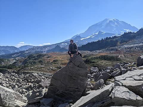
| Dr. Evil wrote: | | Is this an accurate distance measurement? Also, I know there is a tarn up higher that I'm thinking might be a very cool place to spend the night. Is the route straight up the rockpile at end of lake? Ditto for route to top of Preacher? |
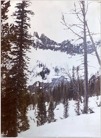
You cross the outlet and head up that ridge on your map to get to the tarn. I've only seen it buried in snow but it looked like a nice area. This is the way up to Preacher's summit too.
 Approaching area of the upper tarn. We took the ridge to the right to reach the summit (not in view).
|
| Back to top |
|
|
puzzlr
Mid Fork Rocks

Joined: 13 Feb 2007
Posts: 7220 | TRs | Pics
Location: Stuck in the middle |
|
puzzlr
Mid Fork Rocks
|
Fri Jun 29, 2018 4:54 pm |
|
|
How was the trail? The USFS took this out of their "inventory" years ago and have not maintained it. For a while a private person kept it open. I haven't been up there in years and I'm curious how easy it is to follow the trail and how much blowdown there is. Many of the area trails got a lot of trees down in the fall storms of 2015.
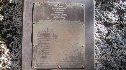
There is a memorial to Trail Blazer George Lewis there somewhere, but I have not seen it.
Also, the Trail Blazers call the tarn up above "Buried Hatchet Lake". I wonder if there's a story behind that other than a reference to Hatchet Lake on the other side of the ridge.
|
| Back to top |
|
|
FiveNines
Member
Joined: 01 Oct 2010
Posts: 526 | TRs | Pics
|
 homeless mountains 324
|
| Back to top |
|
|
Dr. Evil
Member
Joined: 03 Apr 2006
Posts: 36 | TRs | Pics
Location: Woodinville |
|
Dr. Evil
Member
|
Sat Jun 30, 2018 6:02 am |
|
|
How was the trail?
Someone has put a lot of love into the trail. Chainsaw and a lotta work. Trail was easy to follow couple of trees to work around as you can imagine, but nothing difficult.
|
| Back to top |
|
|
Brian Curtis
Trail Blazer/HiLaker

Joined: 16 Dec 2001
Posts: 1696 | TRs | Pics
Location: Silverdale, WA |
| puzzlr wrote: | | Also, the Trail Blazers call the tarn up above "Buried Hatchet Lake". I wonder if there's a story behind that other than a reference to Hatchet Lake on the other side of the ridge. |
That name was coined by George Lewis because he found an old hatchet buried in a tree.
that elitist from silverdale wanted to tell me that all carnes are bad--Studebaker Hoch
that elitist from silverdale wanted to tell me that all carnes are bad--Studebaker Hoch
|
| Back to top |
|
|
puzzlr
Mid Fork Rocks
Joined: 13 Feb 2007
Posts: 7220 | TRs | Pics
Location: Stuck in the middle |
|
puzzlr
Mid Fork Rocks
|
Tue Jul 03, 2018 2:55 pm |
|
|
Thanks Brian. It's fun to hear about these things.
|
| Back to top |
|
|
zimmertr
TJ Zimmerman
Joined: 24 Jun 2018
Posts: 1228 | TRs | Pics
Location: Issaquah |
|
zimmertr
TJ Zimmerman
|
Sun Apr 14, 2019 4:37 pm |
|
|
Happened upon this trail while exploring the middle fork and pratt river areas today. We made it a few miles up the trail until my party got sick of the mud and I let them convince me to turn around. I might have to go back here solo sometime.
Seems like almost all of the elevation gain was done in the first mile or so. A real wet and rooty climb. After that things were mostly flat but there were a few tiny creek crossings that got muddy.
|
| Back to top |
|
|
mtnresqr
Member
Joined: 18 May 2010
Posts: 48 | TRs | Pics
|
|
mtnresqr
Member
|
Mon Apr 15, 2019 1:36 pm |
|
|
My old GPS track, from when i went up mapping trails in Middle Fork (about 2005), shows trail is 3.2 miles. From, meeting Pratt Connector trail, to lake. That track is incorporated in "NorthWest Topos" (<Switchbacks.com>). 1080 feet elevation at Pratt Connector Trail junction and 3800 feet ASL at lake.
That lower portion of creek was logged with Caterpillars, back in 1938-ish, up to about 1700 feet ASL.
|
| Back to top |
|
|
Backpacker Joe
Blind Hiker

Joined: 16 Dec 2001
Posts: 23956 | TRs | Pics
Location: Cle Elum |
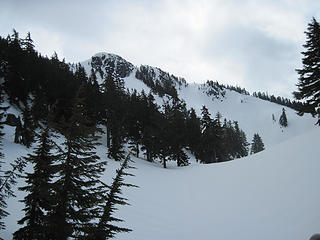
Its a great hike.
 Joe-Bob looking towards the outlet 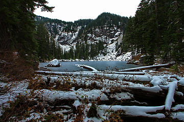 Rainy lake as the trail hits the lake 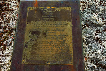 Here's to you Mr. Lewis
"If destruction be our lot we must ourselves be its author and finisher. As a nation of freemen we must live through all time or die by suicide."
Abraham Lincoln
"If destruction be our lot we must ourselves be its author and finisher. As a nation of freemen we must live through all time or die by suicide."
Abraham Lincoln
|
| Back to top |
|
|
zimmertr
TJ Zimmerman
Joined: 24 Jun 2018
Posts: 1228 | TRs | Pics
Location: Issaquah |
|
zimmertr
TJ Zimmerman
|
Mon May 20, 2019 9:46 am |
|
|
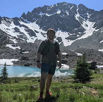
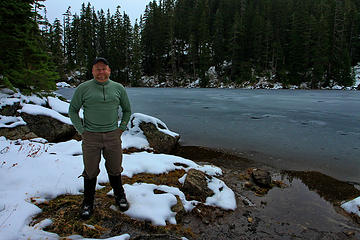
Well I finally made it here yesterday. Pushed hard through the slide alder in an attempt to summit Preacher but failed after about a mile and gaining the ridge that led to Upper Rainy. Encountered a precarious snowfield and decided to call it which turned out to be a good idea as it started raining hard shortly after and the hike back to the car was... somewhat miserable. This trail gets pretty dangerous when wet.
My body aches today.
|
| Back to top |
|
|
flatsqwerl
Member
Joined: 23 Feb 2010
Posts: 1051 | TRs | Pics
Location: tacoma |
Zimmertr, thats a workout just getting to the lake. Snow depth looks a little sad too.
|
| Back to top |
|
|
Backpacker Joe
Blind Hiker
Joined: 16 Dec 2001
Posts: 23956 | TRs | Pics
Location: Cle Elum |
Any snow on the trail?
"If destruction be our lot we must ourselves be its author and finisher. As a nation of freemen we must live through all time or die by suicide."
Abraham Lincoln
"If destruction be our lot we must ourselves be its author and finisher. As a nation of freemen we must live through all time or die by suicide."
Abraham Lincoln
|
| Back to top |
|
|
zimmertr
TJ Zimmerman
Joined: 24 Jun 2018
Posts: 1228 | TRs | Pics
Location: Issaquah |
|
zimmertr
TJ Zimmerman
|
Mon May 20, 2019 2:33 pm |
|
|
The hardest parts getting to the lake were the initial climb after veering from the Pratt River trail and the final climb before you descend into the lake bowl. The rest of the trail, while steep, is not unlike many other Alpine Lakes Wilderness hikes in the area. Perhaps a little muddier.
However, once reaching the lake, the Preacher Mountain summit only really looks to be about an hour away. I'd consider budgeting at least 3 hours to get there the next time, personally. The common routes people seem to take through the forest to the summit involve some of the steepest climbs I've ever done in my life. Upwards of a 60 degree angle at some points near the top of the ridge to the left of the lake. This is what killed me the most. That, and branch belaying on the way down after it started to rain... And then when you reach the ridge you encounter some Class 3/4 scrambles that are way out of my personal comfort zone. Some people's routes appear to flip over to the other side of the ridge and then cross back over later on once you have cleared the cliffs. Unfortunately for us that side of the ridge didn't get as much sun and was covered it too much snow to make the trip feasible for us to reach the summit and get back before dark.
There were small patches of snow starting at around 3500' but were easy to navigate. There is a large snow patch at the top of the final climb before descending into the bowl but is also easy to navigate. Once you drop down to the lake bowl snow patches are much more common, but still aren't too challenging if you don't mind occasionally postholing. However, once you reach ~4500' the snow patches become prevalent and dangerous to cross in some areas given the angle of the terrain. This is of course well above the lake in the forest on your way to the summit.
Rainy Lake is a very achievable day hike today. Preacher Mountain needs another few weeks. Give yourself more time than you think you need.
Gaia Link: https://www.gaiagps.com/datasummary/track/25bca571e5db8e36098c8554b36aec1907547029/?layer=GaiaTopoRasterFeet
Strava Link: https://www.strava.com/activities/2383090916
Here are some more photos:
The East (far) side of the lake had more ice cover.
The lake from half way up the ridge. Hard to get a good view of it through the trees.
The steep terrain on the final climb just before dropping down into the bowl.
The terrible slide alder when bushwacking to the ridge to cross to Preacher.
Some snow after flipping over the ridge to the other side.
|
| Back to top |
|
|
|
|


