| Previous :: Next Topic |
| Author |
Message |
gb
Member


Joined: 01 Jul 2010
Posts: 6311 | TRs | Pics
|
|
gb
Member
|
 Fri May 17, 2019 8:32 am |
|
|
A bad day to be near Pemberton in 2010 - the Meager Peak landslide event
This landslide is described as being the 6th largest in British Columbia in the Holocene. I had heard about the slide from Frank Baumann who sent me a few images back in 2010. He had invited me about three years earlier to fly with him to Mt. Meager to evaluate siting regarding avalanches for a thermal energy project. (After $20 million dollars in expenditure insufficient thermal energy was found to justify further expense).
I can easily envision myself running away from the slide at 87 m/s to avoid being caught. The eyewitness account towards the end is pretty interesting.
The slide inundated Meager Hot Springs I believe and cut-off access in Meager Creek.
|
| Back to top |
  
|
|
Schenk
Off Leash Man
Joined: 16 Apr 2012
Posts: 2372 | TRs | Pics
Location: Traveling, with the bear, to the other side of the Mountain |
|
Schenk
Off Leash Man
|
Fri May 17, 2019 12:48 pm |
|
|
Wow...that was big!
Thanks, interesting for sure.
Nature exists with a stark indifference to humans' situation.
Nature exists with a stark indifference to humans' situation.
|
| Back to top |
|
|
Anne Elk
BrontosaurusTheorist

Joined: 07 Sep 2018
Posts: 2423 | TRs | Pics
Location: Seattle |
|
Anne Elk
BrontosaurusTheorist
|
Fri May 17, 2019 1:32 pm |
|
|
Interesting post, thanks. I'd missed the news reports of this one, perhaps b/c I was in a remote location and not watching/hearing news for 2 months. Anyone familiar with southern Alberta has probably heard of the 1903 Frank Slide, and closer to home, the 1965 Hope Slide was the record volume slide in Canada until it was matched by the Meager slide.
"There are yahoos out there. Its why we cant have nice things." - Tom Mahood
"There are yahoos out there. Its why we cant have nice things." - Tom Mahood
|
| Back to top |
|
|
pcg
Member
Joined: 09 Jun 2012
Posts: 334 | TRs | Pics
|
|
pcg
Member
|
Fri May 17, 2019 5:53 pm |
|
|
|
| Back to top |
|
|
Anne Elk
BrontosaurusTheorist
Joined: 07 Sep 2018
Posts: 2423 | TRs | Pics
Location: Seattle |
|
Anne Elk
BrontosaurusTheorist
|
Fri May 17, 2019 6:48 pm |
|
|
"There are yahoos out there. Its why we cant have nice things." - Tom Mahood
|
| Back to top |
|
|
BeardoMcGrath
Member
Joined: 16 Jan 2018
Posts: 143 | TRs | Pics
Location: Snohomish |
| gb wrote: | | A bad day to be near Pemberton in 2010 - the Meager Peak landslide event
This landslide is described as being the 6th largest in British Columbia in the Holocene. I had heard about the slide from Frank Baumann who sent me a few images back in 2010. He had invited me about three years earlier to fly with him to Mt. Meager to evaluate siting regarding avalanches for a thermal energy project. (After $20 million dollars in expenditure insufficient thermal energy was found to justify further expense).
I can easily envision myself running away from the slide at 87 m/s to avoid being caught. The eyewitness account towards the end is pretty interesting.
The slide inundated Meager Hot Springs I believe and cut-off access in Meager Creek. |
I was in that area only 2 weeks before the slide on a trip to Salal Creek/Athelney Pass. The before and after photos are pretty impressive. I went back to the area in 2017; you can walk right off the road to the confluence of the Lillooet River and Meager Creek to get a sense of the devastation.
I'm not a geology expert but in reading about this it seems that much of the Meager massif was built during the last ice age and so rock is sitting on top of existing glacial ice. And as that ice retreats huge portions of the mountain become unstable. Since the slide the roads up into the upper Lillooet are closed during any extended stretch of hot weather in the summer as a precaution.
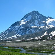
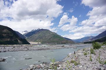 Looking towards the Lillooet Meager Confluence in July 2017. The slide came down from the summit at left into Meager Creek and then blew out debris into the area in the foreground. A severe forest fire affected this area in 2015 to add to the ambiance.
|
| Back to top |
|
|
Anne Elk
BrontosaurusTheorist
Joined: 07 Sep 2018
Posts: 2423 | TRs | Pics
Location: Seattle |
|
Anne Elk
BrontosaurusTheorist
|
Tue May 21, 2019 4:36 pm |
|
|
There was also that huge slide above Johnson's Landing near Nelson, BC in 2012. Although not the same kind of slide, the Globe & Mail was reporting it as a once in 12,000 year event for the central Kootenays. In that case, the slide was precipitated by faster than normal snowmelt followed by very heavy June rains.
While some catastrophic slides are abetted by man (like the logging above the unstable slope at Oso, WA), and mountain areas are inherently unstable, I agree with Beardo that these major slides may become more common as glaciers draw back significantly and climate events become more extreme.
"There are yahoos out there. Its why we cant have nice things." - Tom Mahood
"There are yahoos out there. Its why we cant have nice things." - Tom Mahood
|
| Back to top |
|
|
BeardoMcGrath
Member
Joined: 16 Jan 2018
Posts: 143 | TRs | Pics
Location: Snohomish |
Some more interesting links on the Joffre event:
LeeLau's website: Good before and after photos here. Of amusing note is the new lake forming at the bottom of the flow, "Snapchat Lake", no doubt in reference to the recent fame nearby Joffre Lakes have received due to social media. This fourth Joffre lake appears much less photogenic than its cousins.
The Landslide Blog: Some of the recent posts here have a more technical analysis. Seems like the recent warm spell precipitated the slide but that it was likely a long time coming. I do believe the mechanism is different than for Meager as Joffre is not volcanic (and this slope had a lot less glacial ice).
|
| Back to top |
|
|
Brushbuffalo
Member

Joined: 17 Sep 2015
Posts: 1887 | TRs | Pics
Location: there earlier, here now, somewhere later... Bellingham in between |
I'm joining this party kind of late, but at least not in geologic-time late.  However, when I used to teach my Natural Disasters class one of my favorite short images to show during our Landslides section was this one from a debris flow into Kootenay Lake on July 12, 2012. The boaters escaped by mere seconds.
https://www.wimp.com/epic-mudslide-caught-on-camera-by-roaming-news-team/
Unfortunately there were four fatalities to people on land. However, when I used to teach my Natural Disasters class one of my favorite short images to show during our Landslides section was this one from a debris flow into Kootenay Lake on July 12, 2012. The boaters escaped by mere seconds.
https://www.wimp.com/epic-mudslide-caught-on-camera-by-roaming-news-team/
Unfortunately there were four fatalities to people on land.
| BeardoMcGrath wrote: | | it seems that much of the Meager massif was built during the last ice age and so rock is sitting on top of existing glacial ice. And as that ice retreats huge portions of the mountain become unstable |
You are probably correct that Mt. Meager was built at least partly on top of glacial ice ( supraglacial), as was definitely Mt. Garibaldi, but there is no evidence that there is still ice beneath either volcano. However, each one being built partly upon a poor foundation is still in the process of periodic collapse, aided considerably by modern glacial erosion.
This process of supraglacial volcanism occurs in Iceland today, as well as in a few other places of active volcanism combined with glaciation.
Passing rocks and trees like they were standing still
Passing rocks and trees like they were standing still
|
| Back to top |
|
|
BeardoMcGrath
Member
Joined: 16 Jan 2018
Posts: 143 | TRs | Pics
Location: Snohomish |
| Brushbuffalo wrote: | | You are probably correct that Mt. Meager was built at least partly on top of glacial ice ( supraglacial), as was definitely Mt. Garibaldi, but there is no evidence that there is still ice beneath either volcano. |
Thanks for this clarification! Looking back at the original article the authors cite groundwater seepage, along with glacial erosion, as causes for the 2010 landslide. I know that ever since that time all the roads up in that area are closed if there is ever a hot stretch of weather in the summer, as a precaution.
|
| Back to top |
|
|
BeardoMcGrath
Member
Joined: 16 Jan 2018
Posts: 143 | TRs | Pics
Location: Snohomish |
Anyone been following the big slide up at the head of Bute Inlet in BC? Looks like a big chunk of mountain sheared off at the head of Elliot Creek, a tributary of the Southgate River (west side, below Incisor Peak). So far poor weather has made it difficult to view, but a local helicopter company has been in the area and reports a lot of damage (though in a remote area)
This AGU blog has a a good summary. It looks like the landslide landed right in the big lake at the head of the valley, which precipitated a debris flow out to the Southgate River. Apparently the first sign something was up was tons of woody debris floating around Bute Inlet.
|
| Back to top |
|
|
Brushbuffalo
Member
Joined: 17 Sep 2015
Posts: 1887 | TRs | Pics
Location: there earlier, here now, somewhere later... Bellingham in between |
| BeardoMcGrath wrote: | | Anyone been following the big slide up at the head of Bute Inlet in BC? |
Thanks for the reminder and updated comments.
This is interesting.
Passing rocks and trees like they were standing still
Passing rocks and trees like they were standing still
|
| Back to top |
|
|
gb
Member
Joined: 01 Jul 2010
Posts: 6311 | TRs | Pics
|
|
gb
Member
|
Fri Dec 18, 2020 4:42 pm |
|
|
|
| Back to top |
|
|
Pyrites
Member
Joined: 16 Sep 2014
Posts: 1884 | TRs | Pics
Location: South Sound |
|
Pyrites
Member
|
Sun Dec 20, 2020 11:52 pm |
|
|
Keep Calm and Carry On?
Heck No.
Stay Excited and Get Outside!
|
| Back to top |
|
|
|
|


