| Previous :: Next Topic |
| Author |
Message |
Nancyann
Member


Joined: 28 Jul 2013
Posts: 2318 | TRs | Pics
Location: Sultan Basin |
|
Nancyann
Member
|
 Mon May 20, 2019 1:56 pm |
|
|
Ive been missing one of my favorite places for a while now, so Saturday I did some arm twisting and talked Hiking Partner into checking out the condition of the West Cady Ridge Trail. When we arrived at the junction of F.S. Road 65 and 63, we were the only ones there, but shortly two other vehicles drove by and then turned around. While they chatted with their windows down, presumably about the lake which shall not be named, we began our 4.5 mile roadwalk to the West Cady/Quartz Creek/N.Fork Sky parking lot. That was the last time we saw anyone for the rest of the day.
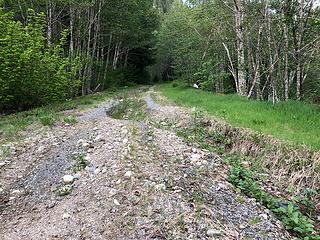 Forest Service Road 6530 5/18/19 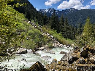 North Fork Skykomish River 5/18/19 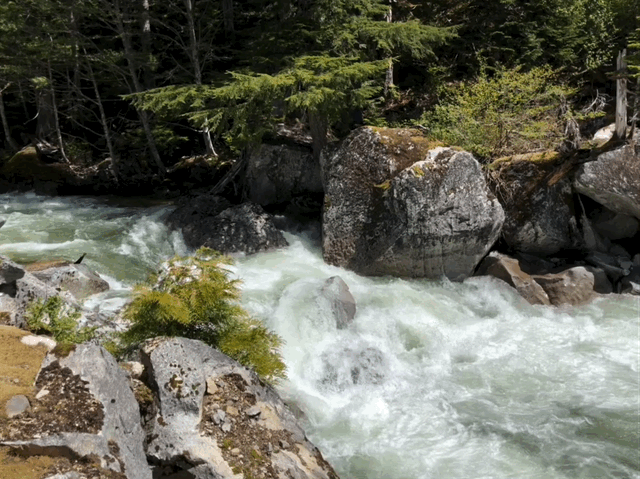 North Fork Skykomish River 5/18/19 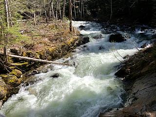 North Fork Skykomish River 5/18/19 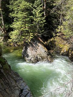 North Fork Skykomish River 5/18/19 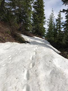 West Cady Ridge Trail 5/18/19 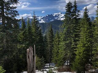 Keyes Peak from the West Cady Ridge Trail 5/18/19 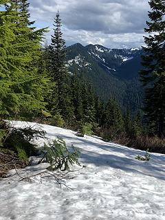 West Cady Ridge Trail 5/18/19 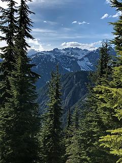 Monte Cristo Peak from West Cady Ridge 5/18/19 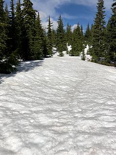 West Cady Ridge Trail 5/18/19 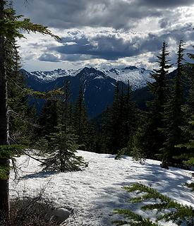 Vesper Peak from the West Cady Ridge Trail 5/18*19 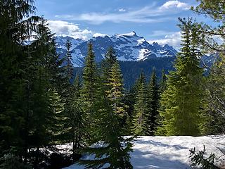 Keyes Peak from the West Cady Ridge Trail 5/18/19 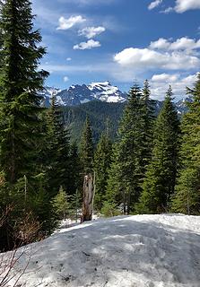 Keyes Peak from the West Cady Ridge Trail 5/18/19 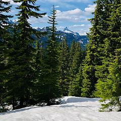 Sloan Peak from the West Cady Ridge Trail 5/18/19
|
| Back to top |
  
|
|
JimK
Member

Joined: 07 Feb 2002
Posts: 5606 | TRs | Pics
Location: Ballard |
|
JimK
Member
|
Mon May 20, 2019 3:50 pm |
|
|
Just a little 17 mile day hike? I can see where there is a lot of solitude now. Thanks for the report. I sure want to get back up that trail again soon.
|
| Back to top |
|
|
Roly Poly
Member
Joined: 02 Jan 2013
Posts: 713 | TRs | Pics
|
Wow, that is a long day but you got some great views.
|
| Back to top |
|
|
Nancyann
Member
Joined: 28 Jul 2013
Posts: 2318 | TRs | Pics
Location: Sultan Basin |
|
Nancyann
Member
|
Mon May 20, 2019 4:17 pm |
|
|
It is a very long dayhike Jim, but made for a pleasant day of solitude. Although on the roadwalk back, Hiking Partner good-naturedly muttered something like so how many miles were you planning on walking today? I had forgotten to tell him.  RolyPoly, of course the views are best once you crest the top of the ridge, but we needed snowshoes to get up there, and who wants to carry snowshoes that many miles?
|
| Back to top |
|
|
timberghost
Member
Joined: 06 Dec 2011
Posts: 1330 | TRs | Pics
|
I know that road is slated to be fixed but so is a lot of places along the Beckler that haven't been addressed. They usually grade the part before Jacks Pass but when I went over it a week ago it was pretty wash board and pothole laced but that's a sign of the times I guess
|
| Back to top |
|
|
Nancyann
Member
Joined: 28 Jul 2013
Posts: 2318 | TRs | Pics
Location: Sultan Basin |
|
Nancyann
Member
|
Tue May 21, 2019 10:45 am |
|
|
Yes, the Beckler River Road was very full of potholes. Not so bad once you get past Jacks Pass.
It doesnt make sense for the Forest Service to spend the large amount of money needed to repair #63. Why would they want to make more work for themselves by making it easier to get to the other trailhead when it is already overrun by a ridiculously huge number of visitors? It will be interesting to see if anything is ever done.
|
| Back to top |
|
|
Kim Brown
Member
Joined: 13 Jul 2009
Posts: 6899 | TRs | Pics
|
The repairs on the 63 road are an on-going Emergency Repair for Forest Owned Roads (ERFO) project. Looks like the repairs will resume in June (probably when the fish window opens up (certain windows of time they arent allowed to do work that might negatively impact fish, perhaps bird nesting as well?). Completion is scheduled for October.
EDIT: the complete Date might just be the date they end work this year, not the project completion date
"..living on the east side of the Sierra world be ideal - except for harsher winters and the chance of apocalyptic fires burning the whole area."
Bosterson, NWHiker's marketing expert
"..living on the east side of the Sierra world be ideal - except for harsher winters and the chance of apocalyptic fires burning the whole area."
Bosterson, NWHiker's marketing expert
|
| Back to top |
|
|
Nancyann
Member
Joined: 28 Jul 2013
Posts: 2318 | TRs | Pics
Location: Sultan Basin |
|
Nancyann
Member
|
Wed May 22, 2019 11:37 pm |
|
|
Thanks for the link, Kim. After seeing how badly the road is undercut in some sections past the second mile, I remain skeptical  . .
|
| Back to top |
|
|
Damian
Member

Joined: 18 Dec 2001
Posts: 3260 | TRs | Pics
|
|
Damian
Member
|
Thu May 23, 2019 10:17 pm |
|
|
Yes Kim seems to have it straight. Every year the FS says the repairs are scheduled for the next year. I'm ok with the road walk for now. My prediction is that it will blow out again one year after it's fixed.
|
| Back to top |
|
|
Kim Brown
Member
Joined: 13 Jul 2009
Posts: 6899 | TRs | Pics
|
| Nancyann wrote: | | Thanks for the link, Kim. After seeing how badly the road is undercut in some sections past the second mile, I remain skeptical . |
They work fast. Once the legal issues were out of the way and they got going on the Suiattle River Road, it was done quickly, considering the massive damage on that road.
I haven't seen any of the damage to this road; I'm curious. ERFO projects fund repair to the pre-damage condition unless a "betterment" is approved, as on the Suiattle Road, where improvements were made to the design, and portions were relocated.
The flyer on FHWA's site says a culvert is being replaced with a fish passage box culvert, which I think would be considered betterment. If that's the case, then the road may be re-routed in those areas it's undercut. Being so close to the river, chances are that is the case.
I'm curious as to the repair design and documentation. Haven't seen any. Will check it out.
"..living on the east side of the Sierra world be ideal - except for harsher winters and the chance of apocalyptic fires burning the whole area."
Bosterson, NWHiker's marketing expert
"..living on the east side of the Sierra world be ideal - except for harsher winters and the chance of apocalyptic fires burning the whole area."
Bosterson, NWHiker's marketing expert
|
| Back to top |
|
|
Nancyann
Member
Joined: 28 Jul 2013
Posts: 2318 | TRs | Pics
Location: Sultan Basin |
|
Nancyann
Member
|
Fri May 24, 2019 10:54 am |
|
|
Thanks, Kim! The original damage to the road is after the bridge over Goblin Creek where a creek with no culvert overran the ditch parallel to the road. It ran right down the middle of the road, and in the subsequent years it has now gone under the road, leaving huge gaping holes in its path.
|
| Back to top |
|
|
lopper
off-route

Joined: 22 Jan 2002
Posts: 845 | TRs | Pics
|
|
lopper
off-route
|
Fri May 24, 2019 7:40 pm |
|
|
Thanks for the report & the pics.
A lot of things have changed in 38 years, but road frustration is not one of them.
Road 63 / Road 65 neighborhood:
Here are 4 pics from a recon/climbing outing to Bear Mtn in 1981.
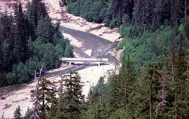 81NfkBridge4 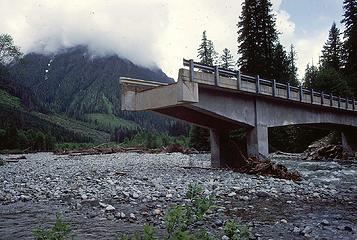 81NfkBridge3 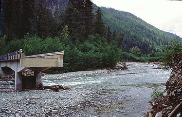 81NfkBridge1 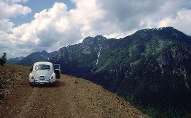 81BearMtnVW
|
| Back to top |
|
|
Kim Brown
Member
Joined: 13 Jul 2009
Posts: 6899 | TRs | Pics
|
| lopper wrote: | | Here are 4 pics from a recon/climbing outing to Bear Mtn in 1981. |
Damn, you're old.
I'll hafta check my old Signpost 'zines & see if there are articles on the floods that caused that damage! wow, that's crazy.
"..living on the east side of the Sierra world be ideal - except for harsher winters and the chance of apocalyptic fires burning the whole area."
Bosterson, NWHiker's marketing expert
"..living on the east side of the Sierra world be ideal - except for harsher winters and the chance of apocalyptic fires burning the whole area."
Bosterson, NWHiker's marketing expert
|
| Back to top |
|
|
Snowdog
Member

Joined: 21 Jul 2006
Posts: 1028 | TRs | Pics
Location: on (& off) the beaten path |
|
Snowdog
Member
|
Sat May 25, 2019 8:26 am |
|
|
Would a bike have been helpful? I have such fond memories of that trail, would love to go back there.
'we don't have time for a shortcut'
'we don't have time for a shortcut'
|
| Back to top |
|
|
Nancyann
Member
Joined: 28 Jul 2013
Posts: 2318 | TRs | Pics
Location: Sultan Basin |
|
Nancyann
Member
|
Sat May 25, 2019 10:23 am |
|
|
Snowdog wrote: Would a bike be helpful? This is a very good question. Within the first two miles from the intersection of F.S. Roads 65 and 63, there is one major washout and another minor creek crossing which would be bumpy but a non-issue. Currently there is a lot of water coming down the first major washout and I personally wouldnt want to take a bike across it. After the bridge over Goblin Creek, there are two sections where the creek or creeks ran down the middle of the road. It would be like trying to ride or push your bike up a creek bed, kind of like the rough spots on the road to Monte Cristo. So its not the best scenario for biking, but doable. I find that just walking fast works for me, and this was the third time I have been up there since the washouts.
Thanks for the bridge photos, lopper, pretty dramatic!
|
| Back to top |
|
|
|
|


