| Previous :: Next Topic |
| Author |
Message |
mtn.climber
Member


Joined: 29 Jul 2008
Posts: 1204 | TRs | Pics
Location: The Lost Horizon |
Going to attempt Windy Peak. Looks like there are two options. Windy Peak trail (7 miles one way), or Windy Creek trail (5 miles one way). Both leave from same general area (3 miles apart from each other).
Is one better than the other? More used? Easier to follow? Not sure how severe the old fire damage is for each route.
Reach for the sky, cuz tomorrow may never come.
Live the life of love. Love the life you live.
Reach for the sky, cuz tomorrow may never come.
Live the life of love. Love the life you live.
|
| Back to top |
  
|
|
Randito
Snarky Member

Joined: 27 Jul 2008
Posts: 9513 | TRs | Pics
Location: Bellevue at the moment. |
|
Randito
Snarky Member
|
 Tue Jul 09, 2019 9:44 pm |
|
|
Which Windy Peak? The one near Iron Gate?
If that one I hiked the 5? years ago and the burned areas already had green regrowing. An umbrella helped keep me cooler in lieu of forest cover.
|
| Back to top |
|
|
mtn.climber
Member
Joined: 29 Jul 2008
Posts: 1204 | TRs | Pics
Location: The Lost Horizon |
The Windy Peak way up in the Pasayten. I think the trail leaves from near Long Swamp campground.
Reach for the sky, cuz tomorrow may never come.
Live the life of love. Love the life you live.
Reach for the sky, cuz tomorrow may never come.
Live the life of love. Love the life you live.
|
| Back to top |
|
|
Randito
Snarky Member
Joined: 27 Jul 2008
Posts: 9513 | TRs | Pics
Location: Bellevue at the moment. |
|
Randito
Snarky Member
|
Wed Jul 10, 2019 6:50 am |
|
|
Yeah. I haven't hiked those trails on the West side. I topped doing a lollipop from Iron Gate , going to Horseshoe basin 1st along the Boundary trail and then back.
The burn was very noticeable along North side, less so on the South. You'll be on the West. I was above timberline in the area where the trails you mentioned approached the summit, so fire damage less unobservable.
But the Tripod fire was in 2006, so you won't be walking through a charred moonscape, but by now regrowth of brush might be an issue.
Have you tried calling the Methow Valley ranger station 509 996 4000 ?
|
| Back to top |
|
|
markweth
Member

Joined: 08 Feb 2017
Posts: 155 | TRs | Pics
Location: Montana |
|
markweth
Member
|
Wed Jul 10, 2019 8:20 am |
|
|
I hiked up Windy Creek from its junction with Cathedral Driveway Trail to the junction just below Windy Peak as part of a long (50+ miles?) loop last September. The Windy Creek Trail was distinct and in reasonably good condition, but it was entirely through an old burn and would be miserable on a hot day as it is very exposed. I'd recommend accessing Windy Peak via Iron Gate Trailhead instead. Some great options for overnight or multinight trips via that access as well! The Iron Gate Road did not live up to its horrid reputation when I drove up there last September. I'm a rather anxious/nervous driver and did just fine in a Honda Element. If you went slow even a regular sedan could have made it.
|
| Back to top |
|
|
yukon222
Member

Joined: 12 Mar 2007
Posts: 1893 | TRs | Pics
|
|
yukon222
Member
|
Wed Jul 10, 2019 9:04 am |
|
|
|
| Back to top |
|
|
iron
Member

Joined: 10 Aug 2008
Posts: 6392 | TRs | Pics
Location: southeast kootenays |
|
iron
Member
|
Wed Jul 10, 2019 9:32 am |
|
|
we came down windy creek in 2013. piece of cake
|
| Back to top |
|
|
wildernessed
viewbagger

Joined: 31 Oct 2004
Posts: 9275 | TRs | Pics
Location: Wenatchee |
Windy Peak via Windy Peak trail
My thoughts on the Peak vs Creek route were that we could park at the camp walk across the road and have at it and not lose / gain elevation both ways going in and out.
Living in the Anthropocene
Living in the Anthropocene
|
| Back to top |
|
|
jstern
Member

Joined: 04 Apr 2010
Posts: 29 | TRs | Pics
Location: Auburn |
|
jstern
Member
|
Wed Jul 10, 2019 8:59 pm |
|
|
We hiked in via the Iron Gate side and camped at Sunny pass last July and did Windy Peak as a there and back. Trail was well defined through the burn area and in July, the wildflowers were awesome.
As Markwerth indicated, it was hot and humid in the low areas as it started off as a nice sunny day. Once we reached around 7500, the breeze picked up and was almost cold.
We didnt go past the junction to the peak, but the trail looked good and well defined beyond the junction. We didnt have any visibility to it as it dropped over the ridge, but prior to that, it looked good.
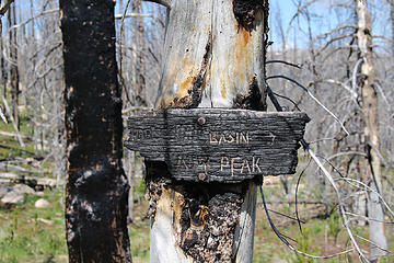 Charred sign 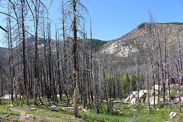 Windy Peak through the trees
"Adventure is just bad planning." - Roald Amundsen
"Adventure is just bad planning." - Roald Amundsen
|
| Back to top |
|
|
|
|


