| Previous :: Next Topic |
| Author |
Message |
TellimaChris
Member


Joined: 02 Jun 2019
Posts: 15 | TRs | Pics
Location: Bellingham, Washington |
I was always curious why the trail on High Divide north of Mt Baker doesnt extend west beyond Excelsior Pass and connect up with the Church Mt trail 4 miles to the west. If it did that would enable a grand traverse of almost 10 miles of unbroken above treeline ridge-top rambling! But for some reason Ive never heard of anyone doing it or read any reports.. though I have scouted both ends of the route previously and figured it quite doable. So I decided to give it a try.
To make this a proper loop I drove up to the Church Mt trailhead and parked my truck, where Ill hopefully end my day. Then I road my bike 2.5 miles and 1000 down the forest road to Mt Baker Highway, which I followed east 8 miles and 1400 UP to the welcome pass trailhead. The road to the trailhead was steep so I stashed my bike in the woods and started walking up, my legs already a bit rubbery from the bike ride. My pace to the pass was slow, both due to the aforementioned bike ride and also because the Welcome Pass trail is really steep, and relentless. 2700 in 2.3 miles. Is there a steeper maintained trail in the North Cascades?
Once on the ridge though, the going was easy and the views expansive. The trail meandered westward, through blueberry hillsides, wildflower meadows and the occasional patch of forest. There were lots of clouds around, obscuring the upper reaches of the higher mountains like Shuksan and Baker, and increasingly over the top of High Divide as well. Sun breaks were interrupted periodically by cold damp and breezy in-the-cloud spells. The wildflowers were truly fantastic.
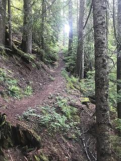 It's steeper than it looks 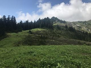 First view of High Divide 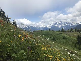 Mt Shuksan peaking through the clouds and wildflowers 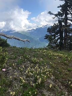 Mt Baker is in those clouds somewhere 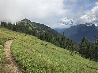 High Divide looking east 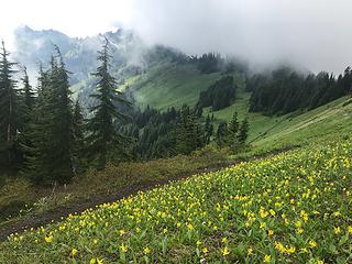 High Divide looking west 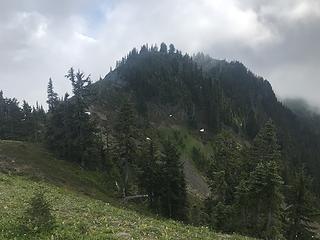 Crux of the divide. I ended up going around to the south (left) of the knob 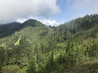 Looking back over the untrailed western part of the divide 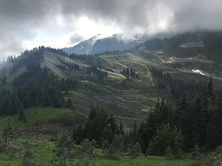 The final stretch, beyond that last ridge is Church meadows 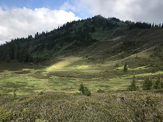 Headwaters of Canyon Creek 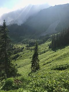 Finally, Church basin meadows! 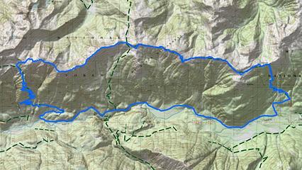 GPS track, 26 miles total
 Snowdog Snowdog
Snowdog |
| Back to top |
  
|
|
olderthanIusedtobe
Member

Joined: 05 Sep 2011
Posts: 7708 | TRs | Pics
Location: Shoreline |
That is really cool, thanks for the TR! I was just up there last week. I followed the boot track from Excelsior Pass toward Church Mtn. for maybe 1/2 mile. I thought it might continue all the way, but as you found it doesn't. On different outings I've followed High Divide from Excelsior Pass to Welcome Pass and also cruised along the ridge from Welcome Pass to the last knoll just above the Yellow Aster Butte lakes. That's all nice terrain up there.
|
| Back to top |
|
|
puzzlr
Mid Fork Rocks

Joined: 13 Feb 2007
Posts: 7220 | TRs | Pics
Location: Stuck in the middle |
|
puzzlr
Mid Fork Rocks
|
 Wed Jul 10, 2019 8:56 pm |
|
|
Beautiful shots. I like your way of trip planning -- "If it goes it will be awesome". Only one way to find out.
|
| Back to top |
|
|
Eric Hansen
Member
Joined: 23 Mar 2015
Posts: 866 | TRs | Pics
Location: Wisconsin |
Thanks! Been up there several times and often contemplated a thru hike but thought the view headed east might be the better of the two options. Either way High Divide is two thumbs up. I've done most of the way from Welcome to Yellow Aster ponds. I posted once, scanning the map of Gold Run Pass to Low Pass as a way to continue eastbound. Someone described it as unappealing.
|
| Back to top |
|
|
TellimaChris
Member
Joined: 02 Jun 2019
Posts: 15 | TRs | Pics
Location: Bellingham, Washington |
I've done that stretch east from Welcome Pass to the Yellow Aster tarns, Gold Run Pass, Low Pass, and Twin Lakes. The headwall going up to Low Pass is steep but manageable, and the basin below is quite beautiful. Other than that it's largely on trails, formal or otherwise. The views definitely get better and the terrain more alpine as you head east. Such a beautiful area!
Now that I know I can hook it up to Church Mt Trail, there's an even grander traverse to be done from Church all the way to Twin Lakes  Probably have that be an overnight though.. Probably have that be an overnight though..
|
| Back to top |
|
|
Eric Hansen
Member
Joined: 23 Mar 2015
Posts: 866 | TRs | Pics
Location: Wisconsin |
Would be nice to do Tomyhoi along the way. Nice sleep spots at tree line there.
Is it possible to continue past Twin Lakes? Traverse Goat Mt., or too sketchy? Going east to Hannegan Peak/Pass could be nice but I remember some discussion of a crux near Mamie Pass. Memory has the tough spot as loose class 4, just east of the promontory east of Mamie Pass.
|
| Back to top |
|
|
James Wells
James Wells
Joined: 27 Aug 2022
Posts: 8 | TRs | Pics
Location: Bellingham WA |
| TellimaChris wrote: | | Now that I know I can hook it up to Church Mt Trail, there's an even grander traverse to be done from Church all the way to Twin Lakes Probably have that be an overnight though.. |
I have attempted this (Winchester to Church) in a day but rain set in during the Excelsior to Church leg and I remembered some steep meadows during a prior time I had done Church to Excelsior so we bailed down Excelsior. With good conditions it's a long but doable day, still very much on my list.
Winchester to Gold Run Pass is feasible along the ridge. From the notch just west of Winchester summit go up to the lump west of Winchester, then down steep meadow to GR Pass.
|
| Back to top |
|
|
D. Inscho
Not bored yet...

Joined: 28 Feb 2010
Posts: 973 | TRs | Pics
Location: Bellingham,WA |
|
D. Inscho
Not bored yet...
|
Wed Aug 30, 2023 7:38 am |
|
|
Nicely done, and beautiful.
The ridge lines up on the Nooksack Crest can be brutal with stout and brush spruce growth. Of course the NE slopes can be open but they are steep. I usually end up doing more elevation gain/loss than desired in that area.
http://david-inscho.smugmug.com/
The key to a successful trip is to do the planning during work hours. -- John Muir
My most memorable hikes can be classified as 'Shortcuts that Backfired'. --Ed Abbey
http://david-inscho.smugmug.com/
The key to a successful trip is to do the planning during work hours. -- John Muir
My most memorable hikes can be classified as 'Shortcuts that Backfired'. --Ed Abbey
|
| Back to top |
|
|
|
|
You cannot post new topics in this forum
You cannot reply to topics in this forum
You cannot edit your posts in this forum
You cannot delete your posts in this forum
You cannot vote in polls in this forum
|
Disclosure: As an Amazon Associate NWHikers.net earns from qualifying purchases when you use our link(s). |


