| Previous :: Next Topic |
| Author |
Message |
fourteen410
Member


Joined: 23 May 2008
Posts: 2629 | TRs | Pics
|
I've been wanting to check this place out for awhile, but a damaged FS 31 prevented me from visiting for years. It is now repaired.
FS 31 is a smooth ride, but FS 3160 will give your suspension a run for its money. Lots of ditches in the road - you'll want high clearance.
The trail to Church Lake starts at the end of 3160. It's not long, but it is steep. After cresting a ridge, Church Lake comes into view, and it's a pretty one. Bearpaw Mountain looms above the lake, but clouds blocked most of the peak today.
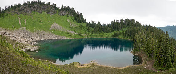 P1250784-Pano
|
| Back to top |
  
|
|
Roly Poly
Member

Joined: 02 Jan 2013
Posts: 713 | TRs | Pics
|
How many miles is the 3160 part of the drive? Is it easier to walk this section? Looks like our clouds just wont yield to summer!
|
| Back to top |
|
|
NorthwestWanderer
Member

Joined: 28 May 2016
Posts: 113 | TRs | Pics
Location: Montana |
This way looks so much more scenic than the boring forest slog on the south side. Thanks for the report!
|
| Back to top |
|
|
fourteen410
Member
Joined: 23 May 2008
Posts: 2629 | TRs | Pics
|
| Roly Poly wrote: | | How many miles is the 3160 part of the drive? Is it easier to walk this section? |
About 4 miles. If you have high clearance, it's easier to drive than walk.
|
| Back to top |
|
|
D. Inscho
Not bored yet...

Joined: 28 Feb 2010
Posts: 973 | TRs | Pics
Location: Bellingham,WA |
|
D. Inscho
Not bored yet...
|
 Sun Jul 14, 2019 9:00 pm |
|
|
Thanks for the visuals and road reports 14410. Your companion looks ready for anything.
http://david-inscho.smugmug.com/
The key to a successful trip is to do the planning during work hours. -- John Muir
My most memorable hikes can be classified as 'Shortcuts that Backfired'. --Ed Abbey
http://david-inscho.smugmug.com/
The key to a successful trip is to do the planning during work hours. -- John Muir
My most memorable hikes can be classified as 'Shortcuts that Backfired'. --Ed Abbey
|
| Back to top |
|
|
kitya
Fortune Cookie

Joined: 15 Mar 2010
Posts: 842 | TRs | Pics
Location: Duvall, WA |
|
kitya
Fortune Cookie
|
Mon Aug 12, 2019 2:06 pm |
|
|
I drove the road 3160 to the trailhead last Saturday in my new Rav4 Hybrid, but I regretted it. It is super narrow and very brushy and very rocky. Even with 8.1 inches of clearance, there were many places where it felt like i was scratching the bottom of the car over rocks and it was a slow and very-very bumpy drive. If you meet any oncoming traffic on this road, this will surely be a big problem and rocks are super sharp too - i would think not only high clearance, but offroad tires would be useful too.
Every other car at the trailhead looked like this:
What is worse, 4 miles is a long road for driving this way, but trail to the lake is super short (less than 0.5 miles), so you are not getting a lot of fun for a lot of non-fun. And most people coming to this trailhead don't look really like typical hikers. The lake was mobbed with many groups camping and fishing. There were several campfires going and people took dirt bikes to the trail up to the lake, completely destroying fragile alpine meadows in several places. There was a lot of mud due to this type of use and several parallel ugly trenches. Maybe it gets better after the lake, but I had no time or desire to explore it more after what I have seen. Poor pikas!
|
| Back to top |
|
|
crazyhiker
Member
Joined: 02 Sep 2011
Posts: 245 | TRs | Pics
|
^Welp, just crossed this one off my list.
|
| Back to top |
|
|
slabbyd
Member
Joined: 21 Jun 2005
Posts: 293 | TRs | Pics
|
|
slabbyd
Member
|
Tue Aug 13, 2019 8:19 am |
|
|
what a bummer. Almost makes you wish that Canyon Creek Road had never been repaired.
|
| Back to top |
|
|
fourteen410
Member
Joined: 23 May 2008
Posts: 2629 | TRs | Pics
|
Meh. It's always had it's fair share of interesting folks on sunny summer weekends. It's all about being smart with timing, seasons, and weather.
But yeah, definitely don't go up here, it's really ugly. And definitely don't go beyond the lake, really ugly up there too. 
|
| Back to top |
|
|
kitya
Fortune Cookie
Joined: 15 Mar 2010
Posts: 842 | TRs | Pics
Location: Duvall, WA |
|
kitya
Fortune Cookie
|
Tue Aug 13, 2019 2:14 pm |
|
|
| fourteen410 wrote: | | Meh. It's always had it's fair share of interesting folks on sunny summer weekends. It's all about being smart with timing, seasons, and weather.
But yeah, definitely don't go up here, it's really ugly. And definitely don't go beyond the lake, really ugly up there too. |
Sure. But I went there on a very rainy day, so just weather might not be enough in summer. And yes, maybe I was just unlucky and people will leave, but tracks from dirt bikes on the meadows and scars from fire rings and campsites along the lake - will not.
|
| Back to top |
|
|
|
|


