| Previous :: Next Topic |
| Author |
Message |
raising3hikers
Member


Joined: 21 Sep 2007
Posts: 2344 | TRs | Pics
Location: Edmonds, Wa |
Tricouni Pk 8102'
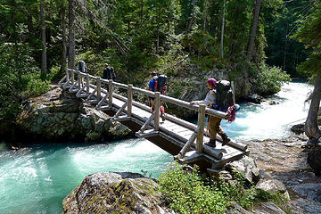
Last year in May 2018, I had tried to climb Tricouni from Thunder Creek but was stopped by the bridge being washed out at McAllister. A couple of hours were spent looking for a way to cross the creek but in early season, there was none. Thanks to the recent TR from trailcat, there was now a way to get across. There is a log jam 1/4 mile up from the old bridge that goes most of the way across. I looked at it the year before but the spot where there were no logs was still too deep.
Fast forward to July 12/13
My oldest son, Jayden, my sister-in-law Tei Tei, and I headed out Friday afternoon to give Tricouni a try. We barely made it to Marblemount in time to get a permit (couple minutes late but the door wasn't yet locked) and still got one. I saw John P in line getting one, too.
We started hiking the Thunder Creek trail around 5pm with the hopes of getting past the log jam for camp. The trail is in great shape and even saw a bear! We made good time to the log jam and then things came to a big slowdown. There were many logs, several years worth and getting half way across was easy. We then tried other options that ended in dead ends. Jayden found a way to the little island in the middle of the roaring, cold creek. It was then a shallow 20' crossing to the final log to the other side of the creek.
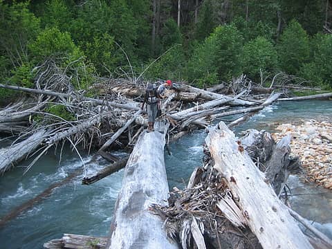 Tei Tei and Jayden on one of the logs 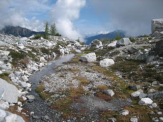 time for a water break 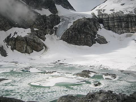 Borealis glacier and lake 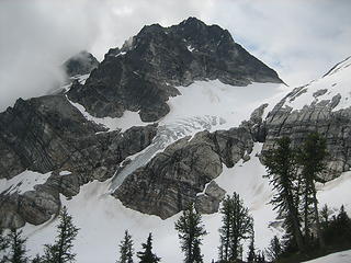 Tricouni 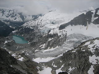 Klawatti and N Klawatti glaciers 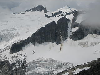 Klawatti and Eldorado Pks 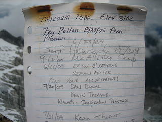 register 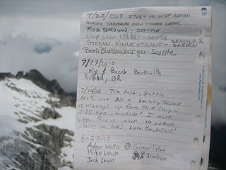 register 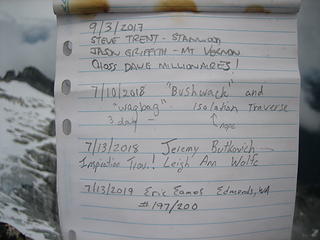 register 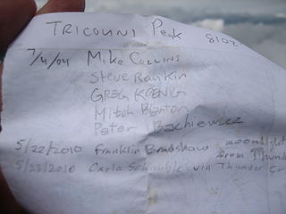 register 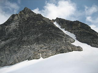 Tricouni and the snow couloir 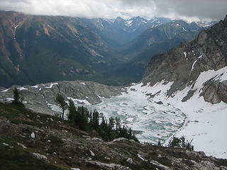 Borealis lake and Fisher Creek valley 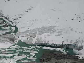 glacier 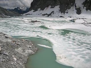 lake 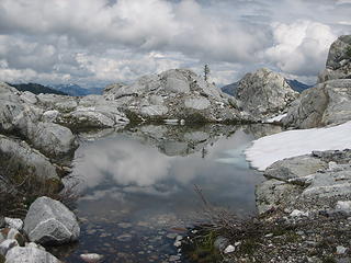 tarn and clouds 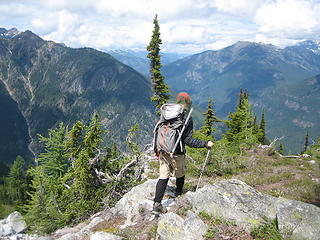 Jayden heading down 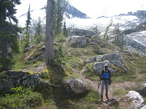 Tei Tei leaving the alpine 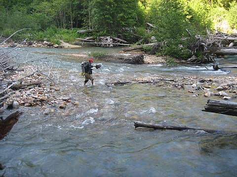 Jayden and the small wet crossing 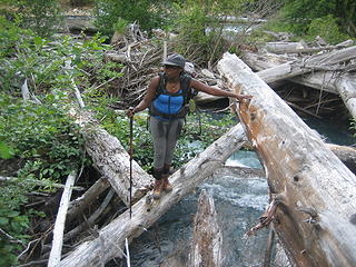 Tei Tei on more logs
|
| Back to top |
  
|
|
Gimpilator
infinity/21M

Joined: 12 Oct 2006
Posts: 1684 | TRs | Pics
Location: Edmonds, WA |
Only 3 to go! How exciting. Any idea where you might finish? Thanks for the register photos. 
|
| Back to top |
|
|
Alden Ryno
Member

Joined: 04 Jun 2019
Posts: 150 | TRs | Pics
Location: Issaquah, WA |
Thank you for the report!
You mentioned the TR by trailcat detailing the crossing of Thunder Creek, but this is the first I've seen it mentioned (apologies, trailcat); though I hadn't really looked for a TR on a way to cross.
I'm glad that y'all had a successful trip(!) and to see that there's a relatively easy way to cross Thunder Creek, for now.
|
| Back to top |
|
|
cascadetraverser
Member

Joined: 16 Sep 2007
Posts: 1407 | TRs | Pics
|
Very cool; way to figure out the Thunder creek conundrum.
Too bad the NCNP isnt gonna resurrect that camp and fix the bridge (no money I guess)
|
| Back to top |
|
|
raising3hikers
Member
Joined: 21 Sep 2007
Posts: 2344 | TRs | Pics
Location: Edmonds, Wa |
| Gimpilator wrote: | | Only 3 to go! How exciting. Any idea where you might finish? Thanks for the register photos. |
It all depends on if the weather eventually cooperates and if I can get into the pickets for a couple tough ones. If I can, then devils tongue could be the last one since it can be done later in the season.
|
| Back to top |
|
|
iron
Member

Joined: 10 Aug 2008
Posts: 6392 | TRs | Pics
Location: southeast kootenays |
|
iron
Member
|
 Mon Jul 15, 2019 9:12 pm |
|
|
| raising3hikers wrote: | Tricouni |
crazy. when we went up at same time of year in 2013, we headed up that icefall (covered with snow). now? NFW.
=view from top
| cartman wrote: | 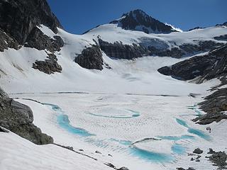 Glacial Lake below Lucky Pass |
=view from below
|
| Back to top |
|
|
olderthanIusedtobe
Member
Joined: 05 Sep 2011
Posts: 7708 | TRs | Pics
Location: Shoreline |
| cascadetraverser wrote: | | Too bad the NCNP isnt gonna resurrect that camp and fix the bridge (no money I guess) |
I talked to a Ranger back in May that was scouting the area looking for cedar logs to use for a bridge repair. I forgot to ask for specifics, but based on the area he was in I can't imagine what other bridge it would've been for.
|
| Back to top |
|
|
silence
Member

Joined: 25 Apr 2005
Posts: 4420 | TRs | Pics
|
|
silence
Member
|
Tue Jul 16, 2019 10:51 am |
|
|
So beautiful up there .... love your photos! Great report.
PHOTOS
FILMS
Keep a good head and always carry a light bulb. Bob Dylan
PHOTOS
FILMS
Keep a good head and always carry a light bulb. Bob Dylan
|
| Back to top |
|
|
Stefan
Member

Joined: 17 Dec 2001
Posts: 5091 | TRs | Pics
|
|
Stefan
Member
|
Tue Jul 16, 2019 11:49 am |
|
|
| raising3hikers wrote: | | Much thanks for Tei Tei and Jayden going on this trip with me, not many people are up for a steep hike in this corner of the cascades! |
Not many people are up for steep hike in ANY corner of the cascades with speed demon raising3hikers!
|
| Back to top |
|
|
puzzlr
Mid Fork Rocks

Joined: 13 Feb 2007
Posts: 7220 | TRs | Pics
Location: Stuck in the middle |
|
puzzlr
Mid Fork Rocks
|
Tue Jul 16, 2019 10:39 pm |
|
|
Congratulations and a nice way to involve your family. On our traverse we skipped Tricouni in our eagerness to get out. I didn't realize that the bridge near McAllister Creek has washed out. It was a beauty, and that must have been quite the flood that took it out. I see online that it was in 2018 -- I track big rain events but don't remember a big storm in 2018.
 August, 2012
|
| Back to top |
|
|
cascadetraverser
Member
Joined: 16 Sep 2007
Posts: 1407 | TRs | Pics
|
OTIUTB: I hope you are right and they rebuild the bridge; that was the plan apparently when I called the NCNP service in winter asking them if and when the bridge would be fixed. They said that was the plan and it was just a matter of when....when I did a follow up call in early May I was told that they were not going to rebuild it and were planning on moving the camp elsewhere.
Who knows, maybe they gave me the wrong info. I like that camp an would love to access that area for ski traversing.
|
| Back to top |
|
|
geyer
Member

Joined: 23 May 2017
Posts: 463 | TRs | Pics
Location: Seattle |
|
geyer
Member
|
Wed Jul 17, 2019 8:35 am |
|
|
| puzzlr wrote: | | I didn't realize that the bridge near McAllister Creek has washed out. It was a beauty, and that must have been quite the flood that took it out. I see online that it was in 2018 -- I track big rain events but don't remember a big storm in 2018. |
puzzlr, when I was researching the inspiration traverse in spring 2018, the bridge was already washed out and various sources told me the washout happened in fall 2017.
|
| Back to top |
|
|
b00
Member

Joined: 29 Sep 2003
Posts: 1144 | TRs | Pics
|
|
b00
Member
|
Wed Jul 17, 2019 12:14 pm |
|
|
| raising3hikers wrote: | | The mosquitos were horrible about half way up to the glacier and followed us to that point. We must have donated enough blood for future mosquito generations. |
on our trip up primus in june 2009, when iron was at the harborview b&b, mcallister ridge was so pleasant because we had a sunshade provided by the swarms of mosquitoes. i vividly remember looking over at handy's back of what was supposed to be a blue shirt, when he took off his backpack, and i could not see any blue. just the black of the mosquitoes enjoying thanksgiving in june. i could of sworn i had a photo, but it on reflection, i probably was unwilling to even pause to get out the camera while under a full attack.
:>)
ps - awesome job! your sister in law and jayden did an amazing getting across the creek and all the way up that ridge! congrats :>)
|
| Back to top |
|
|
olderthanIusedtobe
Member
Joined: 05 Sep 2011
Posts: 7708 | TRs | Pics
Location: Shoreline |
| cascadetraverser wrote: | | OTIUTB: I hope you are right and they rebuild the bridge; that was the plan apparently when I called the NCNP service in winter asking them if and when the bridge would be fixed. They said that was the plan and it was just a matter of when....when I did a follow up call in early May I was told that they were not going to rebuild it and were planning on moving the camp elsewhere.
Who knows, maybe they gave me the wrong info. I like that camp an would love to access that area for ski traversing. |
The Ranger cruised past me, we only talked briefly. I caught up to him later where he had dropped his pack and officially began searching. It wasn't too far after that to the short spur to the former bridge site. I'm making an assumption but it makes sense. It was quite a bit further to the next large bridge (Fisher Creek I think?), and that didn't appear damaged at all.
|
| Back to top |
|
|
cascadetraverser
Member
Joined: 16 Sep 2007
Posts: 1407 | TRs | Pics
|
So I called Marblemount today and the ranger I spoke with was hesitant to give me a firm answer but said right now they are not planning to rebuild the bridge but it sounds like perhaps that may change...
|
| Back to top |
|
|
|
|


