| Previous :: Next Topic |
| Author |
Message |
geyer
Member


Joined: 23 May 2017
Posts: 463 | TRs | Pics
Location: Seattle |
|
geyer
Member
|
 Tue Aug 06, 2019 6:41 am |
|
|
Dates: August 4, 2019 (plus a wee bit past midnight)
Distance: 24.5 miles
Accum. Elevation Gain: 12,200'
Total Humans Seen: 2 people and their dog
Larches: yes
For whatever messed up reason, I got the idea to try Jack Mountain in a day. The Jerry Lakes area was supposed to be beautiful, and even though it would likely end up being my most physically demanding day in the mountains yet, I thought I could pull it off. (I thought I could pull it off in less time than I did, but the body and mind act in strange ways after they've been subjected to a lot of stress.)
I started from the Canyon Creek TH in the early hours of Sunday morning and was immediately surprised at how brushy the trail was and how there were absolutely no signs at the trailhead indicating that a trail went to the Crater Mountain Lookouts. There weren't signs for the split in the trail from Jackita Ridge either and I nearly missed the turnoff... Anyway, the switchbacks went quickly in the dark and I made it up to lookout #2 around sunrise and soaked in the panoramic views of the entire North Cascades south of Hwy 20.
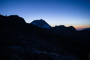
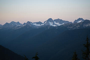 views from the trail 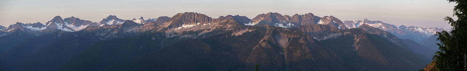 Pano 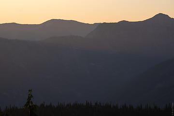 trail from Mill Creek up to Cady Pass 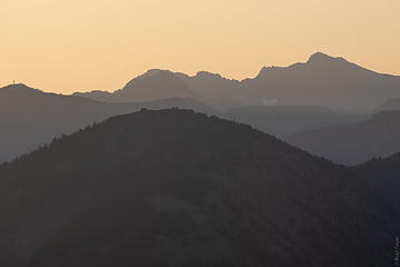 Slate Peak LO at left 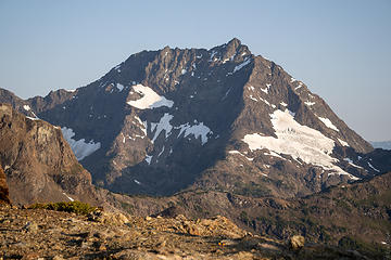 First view of Jack 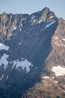 "How the heck am I going to climb that??" 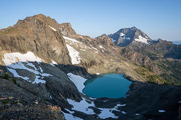 What a sight 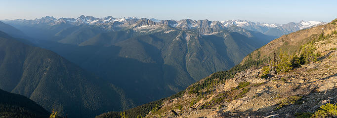 Elija Ridge has piqued my interest 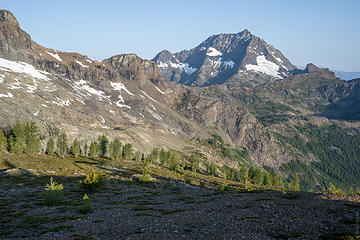 larches too! 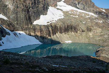 can you spot the human+dog? 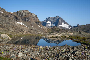 tarn on the way to the moraine 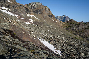 Moraine crossing 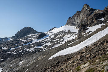 Jerry Glacier 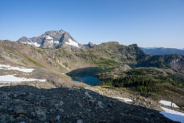 Jerry Lakes 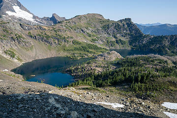 so many larches 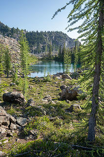 This lake was wonderful 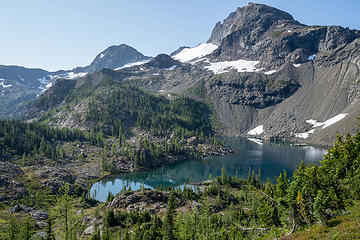 Back up high above the lakes 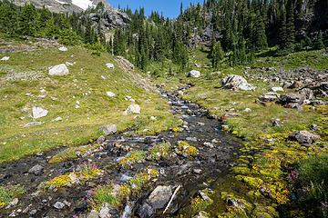 Crater creek headwaters 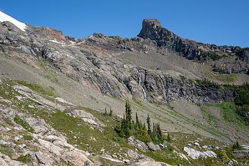 interesting waterfalls 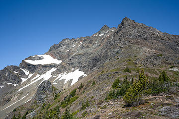 The route comes into view 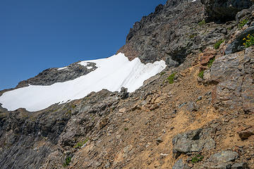 Lobstah claw from the slung boulder 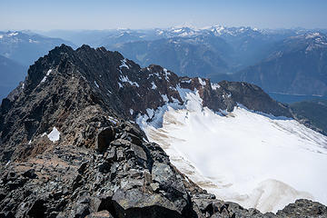 Summit Success! 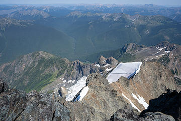 Note the slabs in the snowfield from what must have been a big avalanche 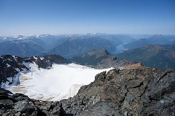 Nohokomeen + Ross 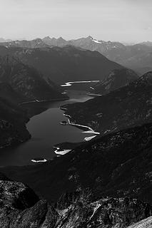 Ross Lake  Looking back to the Jerry Glacier 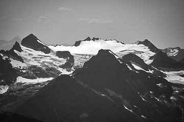 Snowfield 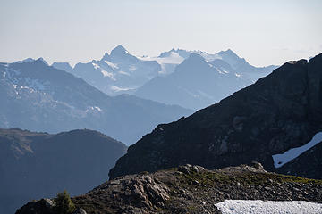 Smoke season is here 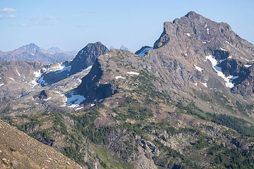 That north ridge of crater looks nice 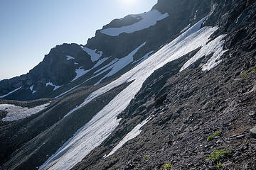 "best part of the route" 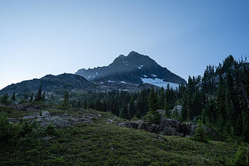 Light playing games 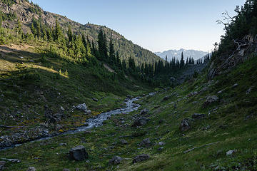 drainage 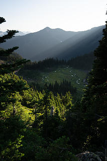 Fantastic light  It was like my conscious brain had a front row seat to the increasingly dominant subconscious part of my brain that it couldn't control. My legs only seemed to be moving because they were on autopilot - pure brain stem motor control. Anytime I came across a downed log, it was as if there was a disconnect between my conscious brain and that motor control, because I had to stop and think very hard about how to get over it. It was like my conscious brain had a front row seat to the increasingly dominant subconscious part of my brain that it couldn't control. My legs only seemed to be moving because they were on autopilot - pure brain stem motor control. Anytime I came across a downed log, it was as if there was a disconnect between my conscious brain and that motor control, because I had to stop and think very hard about how to get over it.
 Goodnight, Jack
|
| Back to top |
  
|
|
cascadetraverser
Member

Joined: 16 Sep 2007
Posts: 1407 | TRs | Pics
|
Wow....that is a lot in one day. Strong work! As I was gazing that direction this past July I really was keen on going there. I think I will take a few days though. Appreciate the TR and beta.
|
| Back to top |
|
|
Brushbuffalo
Member

Joined: 17 Sep 2015
Posts: 1887 | TRs | Pics
Location: there earlier, here now, somewhere later... Bellingham in between |
Phenomenal endurance, both physically, and on that peak, mentally and emotionally.
I just love this picture. Such depth and beauty.
Passing rocks and trees like they were standing still
Passing rocks and trees like they were standing still
|
| Back to top |
|
|
b00
Member

Joined: 29 Sep 2003
Posts: 1144 | TRs | Pics
|
|
b00
Member
|
Tue Aug 06, 2019 9:08 am |
|
|
| geyer wrote: | | I think the beta to follow another climbers' peakbagger gpx track is fairly overstated. There is one location where you would cliff out if not for a hidden corkscrewing meanuver up or down the cliff, but other than that, it's a choose-your-own adventure up to the top. |
strong!!!!!!!!!!!!!!!!!!!!!!!!!!!!!
funny how different people interpret a route quite differently. i found scott rice's gps track indispensable(along with stefan's t/r). so many places that we did not go to along the route looked so much harder. maybe because i am definitely not as strong as you and likely considerably less athletic, i appreciated going the easiest way. also, maybe because i'm friends with scott(and the two others who were climbing with him that day) and stefan, and i had been in the mountains with them multiple times, i know a little how they see things and that makes it easier for me to apply their route info to my skills, or lack of.
thanks for the fun read, great pics and bringing back all the memories. i sure wish i could be as strong as you! great work!
:>)
|
| Back to top |
|
|
Backpacker Joe
Blind Hiker

Joined: 16 Dec 2001
Posts: 23956 | TRs | Pics
Location: Cle Elum |
That trip would be amazing in three days! In one thats super human. Nice work there Clark!
"If destruction be our lot we must ourselves be its author and finisher. As a nation of freemen we must live through all time or die by suicide."
Abraham Lincoln
"If destruction be our lot we must ourselves be its author and finisher. As a nation of freemen we must live through all time or die by suicide."
Abraham Lincoln
|
| Back to top |
|
|
GaliWalker
Have camera will use

Joined: 10 Dec 2007
Posts: 4929 | TRs | Pics
Location: Pittsburgh |
|
GaliWalker
Have camera will use
|
Tue Aug 06, 2019 10:43 am |
|
|
I thought heading in to Jerry Lakes and back was tiring; you went up Jack on top of that! 
|
| Back to top |
|
|
Fletcher
Member

Joined: 29 Jul 2009
Posts: 1870 | TRs | Pics
Location: kirkland |
|
Fletcher
Member
|
Tue Aug 06, 2019 10:48 am |
|
|
Damn strong effort. Jerry Lakes is really nice. I was there a couple years ago on an attempt on the south face but got stormed off right where the route began to get serious. I went back and did the Nohokomeen route the next spring and was glad I did!
|
| Back to top |
|
|
geyer
Member
Joined: 23 May 2017
Posts: 463 | TRs | Pics
Location: Seattle |
|
geyer
Member
|
Tue Aug 06, 2019 5:34 pm |
|
|
| b00 wrote: | | funny how different people interpret a route quite differently. |
Thanks so much for your report! I read it top to bottom multiple times before heading out! I would have been tempted to peel off-route and go up too early if I hadn't remembered you saying how the traverse over to the lobster claw/boulder felt longer than you'd expect. I mostly just followed my instinct in choosing my route -- "does this look class 3? No? Ok that's not the route" -- and that got me to the top. On the way down, I went a different way that felt much less chossy, almost a descending staircase. But if you had to ask me for any specifics, my memory is pretty hazy already
| Backpacker Joe wrote: | | That trip would be amazing in three days! |
I bet it would! Already scheming ways to get back there in prime larch season
| Fletcher wrote: | | Damn strong effort. Jerry Lakes is really nice. I was there a couple years ago on an attempt on the south face but got stormed off right where the route began to get serious. I went back and did the Nohokomeen route the next spring and was glad I did! |
I saw your peakbagger summit of Jerry Lakes Peak before I left. I was curious about who had been there and your group was the only recorded ascent on the site. Nohokomeen looks so much better.
|
| Back to top |
|
|
raising3hikers
Member

Joined: 21 Sep 2007
Posts: 2344 | TRs | Pics
Location: Edmonds, Wa |
Nice pics on the now lesser climbed route up Jack. Your TR is a reminder to go in that way to tag the Jerry lake area pks during larch season.
Thanks for sharing your trip!
|
| Back to top |
|
|
wolffie
Member

Joined: 14 Jul 2008
Posts: 2693 | TRs | Pics
Location: Seattle |
|
wolffie
Member
|
Wed Aug 07, 2019 5:12 pm |
|
|
Do you have any photos of the damaged Canyon Ck bridge? I'm trying to assess the crossing's difficulty.
Some people have better things to do with their lives than walking the dog. Some don't.
Some people have better things to do with their lives than walking the dog. Some don't.
|
| Back to top |
|
|
geyer
Member
Joined: 23 May 2017
Posts: 463 | TRs | Pics
Location: Seattle |
|
geyer
Member
|
Wed Aug 07, 2019 5:42 pm |
|
|
| wolffie wrote: | | Do you have any photos of the damaged Canyon Ck bridge? I'm trying to assess the crossing's difficulty. |
No pictures, but there are two large logs spanning in the exact location of the bridge. The bridge is only serving to support the logjam
@r3h -- and I'm sure it'll only take you a half day to get there and back 
|
| Back to top |
|
|
Kenji
Member
Joined: 18 May 2010
Posts: 320 | TRs | Pics
Location: Seattle |
|
Kenji
Member
|
Wed Aug 07, 2019 6:07 pm |
|
|
| wolffie wrote: | | Do you have any photos of the damaged Canyon Ck bridge? I'm trying to assess the crossing's difficulty. |
|
| Back to top |
|
|
fourteen410
Member

Joined: 23 May 2008
Posts: 2628 | TRs | Pics
|
|
| Back to top |
|
|
Bootpathguy
Member
Joined: 18 Jun 2015
Posts: 1790 | TRs | Pics
Location: United States |
| geyer wrote: | | The Lakes are gorgeous and the fish in the middle lake (5915) were feasting on all the bugs. I'd bring a rod if I went back |
Thanks for saying "rod" instead of "pole"
Drives me insane every time I hear, or read, fishing "pole"
Folks! Its a fishing "rod" or fly-fishing "rod" not a....pole!
Experience is what'cha get, when you get what'cha don't want
Experience is what'cha get, when you get what'cha don't want
|
| Back to top |
|
|
geyer
Member
Joined: 23 May 2017
Posts: 463 | TRs | Pics
Location: Seattle |
|
geyer
Member
|
Wed Aug 07, 2019 8:20 pm |
|
|
The lake near LO #2 looked so much greener and opaque 9 years ago!
|
| Back to top |
|
|
|
|


