| Previous :: Next Topic |
| Author |
Message |
MountainBoo87
Member


Joined: 16 Aug 2019
Posts: 2 | TRs | Pics
|
Gaia folder w/ my track and waypoints - https://www.gaiagps.com/datasummary/folder/bb21a408-fce9-47ca-88d7-a54fe34e7317/?layer=caltoposlope,CalTopo,GaiaTopoRasterFeet
GPX track - https://www.gaiagps.com/public/NqB44hJkTilfgAE5xzDlaYuw
I started at the Andrews Creek TH off Chewuch River Road. Road is closed 2 miles past the TH and 4 miles south of the 30-Mile TH. I didn't want to drive up and around to the Cathedral Driveway TH nor did I want to climb a 1000' from the creek to the TH at the end of my trip. Though, going this way would save you the off-trail travel to get to Remmel.
Day 1 - Didn't get started until 5pm, so I went up Andrews Creek trail about 10 miles and made a totally random camp on a creek sandbar. If your day 1 starts this late, camp at the good spot about 8 miles up the trail.
Day 2 - Left the trail for Remmel abut 9.5 miles from the TH. Bushwhacked through 3 to 4-foot undergrowth and a sh## ton of burn and blow downs as you work your way up to Colman Ridge Trail. Not fun, yet not brutal. If there was a heavy dew or rain the day prior, you'd get soaked here. There is a great camping spot at the top of Colman Ridge before you drop down into a small basin to work your way to the Four Points Lake trail and up to Remmel. I didn't camp there, but if it would be a great place to camp if you ran out of energy to get to Remmel and over to four points lake on day one.
Remmel is a total walk up as there used to be a fire lookout there many years ago.
From Remmel I hiked down the Four Points Lake trail to trail 510 where there's a potential for a ford through the Chewuch River. Prior trips this year had to ford and I too changed out of my boots. It was very easy and likely by now, you can just rock hop over. This was the only place where I had to ford and shouldn't be an issue for the rest of the year.
Trail 510 was burned to death ~15 years ago and is slowly making a recovery. I hiked up the trail ~2 miles to point 44.8 on the map and found a great camp right by the creek where you leave the trail for Apex.
Day 3 - I left mile 44.8 camp and went off trail up and over Apex. This wasn't hard bushwhacking at all and the last ~700' up is nice open meadow. Go down the north side of Apex to the Boundary Trail and go east a mile or so to Tungsten creek. Go off trail up the east side of Tungsten creek and work your way up Wolframite Mt., which is a total walk up. Back to the Boundary Trail and go west ~5 miles to upper Cathedral Lakes. Tons of camping here.
Day 4 - I did Amphitheater first by hiking west on the Boundary Trail and going left at the fork to circle back east and up Amphitheater. The horse trail goes about a 150' from the summit and it's a fun easy walk up to the little rock pile that makes the summit of Amphitheater. I walked all over the rim for fantastic views.
***The trail works its way up to the rim of Amphitheater where you go right towards the summit. At the point where the trail connects to the rim, there's a gully down towards Cathedral. Take this fun low class 3 gully down to the Cathedral Lakes basin. This will save you from walking back around and give you an opportunity to get some water and head for Cathedral. You could go up this gully instead of the gentle hike around and up Amphitheater. I didn't as I needed to stretch my legs in the morning.
Now for the real scramble fun of the trip... Cathedral Peak! I followed the route beta from the book Washington's Highest Mountains Basic Alpine & Glacier Routes by Peggy Goldman.
The Beta is perfect and as you'll see in the picture of the airy step, I down climbed ~10', stepped across the top of the rock and up. On the descent, I jumped down as it was a good 4' over and 2' down onto a flat rock that's a good square yard wide. The additions to the pic should make sense. Jumping on the descent felt safer and quicker than down climbing.
Airy step pic - https://1drv.ms/u/s!AoUgFYf5RN0ChK51aff56ebKGYrM5A
Day 5 - Left Upper Cathedral Lakes camp and hiked out 18 miles and 4000' loss back to the TH. You could hike out 4 or 5 miles to the Spanish basin area the day prior as there is a couple places to set camp. If you pass Spanish basin then you'll have to hike another 5 miles until you can find a decent spot to camp. The last 8 miles out is through burned out forest, so it's exposed, hot and dusty. Back at the Andrews Creek TH, there's easy access to the creek for a post outing bath. Highly recommend it.
I wore shoes for a majority of the trail hiking and carried my boots for off trail travel. I was glad I did. No need for any gear other than poles. Plenty of water throughout the trip. End Gaia stats were 58.5 miles and 14,400' gain/loss. I did it as a five-day trip as I had stuff to do before leaving town on day one. Could be a four-day trip if you start in the morning and not 5pm from Andrews Creek.
|
| Back to top |
  
|
|
Nancyann
Member
Joined: 28 Jul 2013
Posts: 2318 | TRs | Pics
Location: Sultan Basin |
|
Nancyann
Member
|
 Sat Aug 17, 2019 12:19 pm |
|
|
Excellent first trip report! I think you are the peakbagger we met on Apex on July 28. If so, how did your pics of the bobcat turn out?
The Chewuch is still a little high on the way up to Four Point Lake. We just got back from another awesome week up in the area.
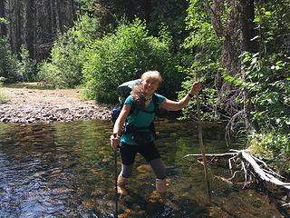 Fording the Chewuch on the trail to Four Point Lake 8/15/19
|
| Back to top |
|
|
MountainBoo87
Member
Joined: 16 Aug 2019
Posts: 2 | TRs | Pics
|
Hi Nancy!
Thank you! Yes, we met on Apex. Pics came out below average as the bobcat blended in w/ the terrain too well.
Glad you had another successful trip!
|
| Back to top |
|
|
Nancyann
Member
Joined: 28 Jul 2013
Posts: 2318 | TRs | Pics
Location: Sultan Basin |
|
Nancyann
Member
|
Sat Aug 17, 2019 3:32 pm |
|
|
It looks like your Pasayten loop went well. Hope to see some more TRs from you in the future!
|
| Back to top |
|
|
Gil
Member

Joined: 29 Sep 2004
Posts: 4062 | TRs | Pics
|
|
Gil
Member
|
Sun Aug 18, 2019 8:14 am |
|
|
Nice report. Love that area.
Friends help the miles go easier.
Klahini
Friends help the miles go easier.
Klahini
|
| Back to top |
|
|
|
|
You cannot post new topics in this forum
You cannot reply to topics in this forum
You cannot edit your posts in this forum
You cannot delete your posts in this forum
You cannot vote in polls in this forum
|
Disclosure: As an Amazon Associate NWHikers.net earns from qualifying purchases when you use our link(s). |


