| Previous :: Next Topic |
| Author |
Message |
Bluebird
suffering optional


Joined: 22 Jan 2014
Posts: 199 | TRs | Pics
Location: United States |
|
Bluebird
suffering optional
|
 Mon Nov 11, 2019 9:54 pm |
|
|
One of my favorite methods for picking a destination is "I haven't been there yet". Brenda, Steven and I hiked to Bootjack and Highchair in October and I was smitten by the cool looking mountain to the south that I initially mistook for Hawkins (which I summited last November with the other Colin)... Steven identified it later as Mt Harding. I was able to talk Brenda, Alper, Colin and Brian into joining me.
We reached the TH around 8am and started hiking shortly afterwards on the signed but not necessarily obvious Scatter Creek trail. If you reach the vehicle ford across Scatter Creek, you've missed it. The trail starts out pleasant but then steepens with lots of rocks, roots and ice. We had expected the trail to be worse... but there's always time for that to happen, right? The crossing of a Scatter Creek tributary was very icy but not too difficult (yet).
We continued up the trail and reached the junction with the Lake Ann trail (which has lost its sign) about 1300 gain from the TH and continued to the signed Scatter Creek trail, which basically disappeared after a campsite near Scatter Creek. But no matter, just follow uphill. We found occasional flags, mostly in the dirt. Not much of a bushwhack but probably more so in summer conditions. We crossed Scatter Creek around 4900-5000 elevation and continued through some open fields, forest and then, a wide swatch of avalanche debris before finding the head of the creek valley. There were also a couple of cairns along the way here.
At the head of the valley, we discussed the route and found most of the GPS tracks we had trended right and then left, above a cliffy bit to reach the pass above us. I lead up some snow and ended up on trail again, although often covered in snow or ice. The trail was intermittent from what I could tell, or maybe I just lost it in the snow and ice... but it lead us up to the pass.
I need to keep learning the lesson about how high traverses don't always save time/energy over dropping down, so I lead us on a high traverse that quickly became steep and unpleasant. The guys weren't too happy with my route choice, but they didn't want to take over either. I dropped down some steep stuff with a light coating of snow on it, which no one liked either.
At this point we crossed a snow covered, reddish boulder field and then entered some kinda snowy rock/forest stuff. It is easier to drop down here instead of maintaining elevation. We ended up dropping down about 800 feet from the pass. There's some slide alder to deal with but it wasn't too bad.
At a large boulder field that was thankfully mostly melted out, we traversed across.
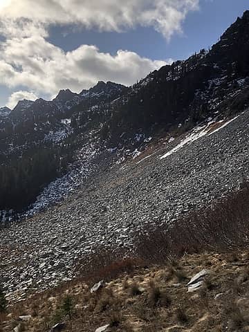 here it is from afar.
|
| Back to top |
  
|
|
puzzlr
Mid Fork Rocks

Joined: 13 Feb 2007
Posts: 7220 | TRs | Pics
Location: Stuck in the middle |
|
puzzlr
Mid Fork Rocks
|
Tue Nov 12, 2019 12:37 am |
|
|
Harding is a satisfying summit -- it takes a lot of work to get there. Too bad you couldn't add Solomon in, but you were dealing with some conditions that made the whole day hard enough with just one peak. Congrats. You're really tearing it up out there!
|
| Back to top |
|
|
Jake Robinson
Member

Joined: 02 Aug 2016
Posts: 521 | TRs | Pics
|
Nice report! You really have a knack for picking interesting, lesser-known destinations 
|
| Back to top |
|
|
neek
Member

Joined: 12 Sep 2011
Posts: 2337 | TRs | Pics
Location: Seattle, WA |
|
neek
Member
|
Tue Nov 12, 2019 9:56 am |
|
|
Interesting, I wonder if one could loop in Scatter as well as Solomon in summer.
|
| Back to top |
|
|
Bluebird
suffering optional
Joined: 22 Jan 2014
Posts: 199 | TRs | Pics
Location: United States |
|
Bluebird
suffering optional
|
Tue Nov 12, 2019 9:57 am |
|
|
neek, I'd expect so. Scott Rice's entry in the register mentioned that he came on a traverse from Scatter.
|
| Back to top |
|
|
Mike Collins
Member
Joined: 18 Dec 2001
Posts: 3097 | TRs | Pics
|
|
| Back to top |
|
|
|
|
You cannot post new topics in this forum
You cannot reply to topics in this forum
You cannot edit your posts in this forum
You cannot delete your posts in this forum
You cannot vote in polls in this forum
|
Disclosure: As an Amazon Associate NWHikers.net earns from qualifying purchases when you use our link(s). |


