| Previous :: Next Topic |
| If you have summited Silver in the winter, did you stay on ridge thru steep trees, or go around to the right side? |
| Stayed on ridge up thru steep trees |
|
50% |
[ 4 ] |
| Around on the right side |
|
50% |
[ 4 ] |
|
| Total Votes : 8 |
|
| Author |
Message |
Pribbs
Member


Joined: 13 Aug 2010
Posts: 179 | TRs | Pics
Location: Sammamish, WA |
|
Pribbs
Member
|
 Fri Mar 13, 2020 11:10 am |
|
|
I have been up Silver twice from the PCT and once last spring from the logging roads/meadows up the north basin and ridge, but never from the Annette Lake Trail (winter route).
There was a road closed sign blocking the dirt road to the Annette Lake TH, but we went around it. You do need high clearance and ideally AWD/4WD to reach the trailhead due to the snow on the road. We set off at 7:50 making quick work of the trail portion. You do need microspikes once you reach the first powerline crossing because the trail is compact icy snow from there on. After about 2 1/3 miles in a bit over an hour, we reached the top of the switchbacks and went a slight bit further until the trail actually leveled off at 3200 feet, and here we put on our snowshoes and headed up through the steep but peaceful forest. At about 3600 feet we reached a small open area where we encountered footprints from the previous day. We followed the tracks up back into the woods, where the slope got really, really steep. At around 4300 feet things leveled off a bit as we entered the start of the old glacial basin.
We went up to the top of an obvious saddle ahead and came to a well-groomed large XC ski road and followed that briefly to a bend at it's high point at the base of the larger part of the big basin at 4600 feet.
We headed up the middle of the snowfield until around 4900 feet at the base of a much steeper section to get up to a saddle between the ridge and the bump known as Silver Lining. Here you want to get out ice axes to ascend this, as the slope was steeper and more icy/crusty. Above this steep section the summit rose ahead.
At around 5100 feet we found an easy way up onto the ridge. The ridge was pretty fun and not too challenging. There we a couple steps to go over and some things to skirt around. Just stay away from cornices.
Once we reached a small bump on the ridge, the flat part of the ridge was about to end and give way to very steep snow with really brushy frozen snowy trees, and cliffs not far to the left. According to GPS tracks I had downloaded on Gaia, some tracks did appear to stay high on the ridge and go through the trees. But the frozen snowy trees looked nasty, and the there were some steep snow steps that looked sorta technical.
I know the boot path drops off here to the right side to wrap around the back side to go up a talus field, which is what other GPS tracks showed, as well. So we opted to trade our snowshoes for crampons and drop off the ridge to the right. We crossed some pretty steep and very firm and icy snow; crampons were certainly required here. Our ice ax spikes were only able to penetrate the top fresh inch or two of snow before hitting a compact icy snow underneath, so there were times where we had to face in and side-step while slamming our picks into the slope.
We finally reached a section that got steeper and even icier with some exposed talus in places, including in our run-out if we were to fall. If snow scrambling had a class system like rock, this would be pushing class 4 stuff. If the snow was not as icy, there would be no issue. But due to the treacherous snow conditions and satisfied with what we already did (especially me being to the top 3 times before), we opted to not go any further across this slope and bail and retreat back to the ridge to take break and enjoy the views. Picture below shows where we turned back. You can see the rocks in the run out. The photo doesn't do justice to the steepness.
The views from the ridge are pretty splendid, featuring the Snoqualmie Pass area, Kaleetan and Chair, Thomson, and Stuart.
We kept our crampons on until the bottom of that steep part of the basin snowfield and then we were actually able to get back down to the trail without snowshoes.
Got back to the trailhead around 3:15pm. 7.5 miles, 3800 feet of gain, 7.5 hours
http://www.movescount.com/moves/move330405517
|
| Back to top |
  
|
|
Schroder
Member

Joined: 26 Oct 2007
Posts: 6719 | TRs | Pics
Location: on the beach |
|
Schroder
Member
|
Fri Mar 13, 2020 11:56 am |
|
|
I've been up Silver many times in the winter and always just followed the trail to within about a half mile of Annette Lake and then gained the ridge to the top. I've never gone into that basin.
|
| Back to top |
|
|
Pribbs
Member
Joined: 13 Aug 2010
Posts: 179 | TRs | Pics
Location: Sammamish, WA |
|
Pribbs
Member
|
Fri Mar 13, 2020 12:13 pm |
|
|
| Schroder wrote: | | I've been up Silver many times in the winter and always just followed the trail to within about a half mile of Annette Lake and then gained the ridge to the top. I've never gone into that basin. |
Seems like that route up the giant open slope above the lake would have higher avy risk. Even on a low-risk day like yesterday, that whole slope was pretty crusty/icy and would've been crampons all the way up. Almost all tracks I found used the ridge approach, which was super fun and scenic.
|
| Back to top |
|
|
Schroder
Member
Joined: 26 Oct 2007
Posts: 6719 | TRs | Pics
Location: on the beach |
|
Schroder
Member
|
Fri Mar 13, 2020 12:23 pm |
|
|
You go up before you get to the large open slope and just hit the top corner of it
|
| Back to top |
|
|
puzzlr
Mid Fork Rocks

Joined: 13 Feb 2007
Posts: 7220 | TRs | Pics
Location: Stuck in the middle |
|
puzzlr
Mid Fork Rocks
|
Fri Mar 13, 2020 6:03 pm |
|
|
That is quite a super-zoom on your camera. Cool view of the Granite Mountain lookout. And the cornice is  When I climbed Silver in winter I left the trail somewhere between where you did and where Schroder does. We also did not go into the basin.
|
| Back to top |
|
|
revolutionaryboredom
Member
Joined: 20 Mar 2020
Posts: 1 | TRs | Pics
|
> There was a road closed sign blocking the dirt road to the Annette Lake TH, but we went around it.
Don't you think you maybe shouldn't have?
|
| Back to top |
|
|
penquin
Member

Joined: 31 Mar 2008
Posts: 27 | TRs | Pics
Location: The Wild Yonder |
|
penquin
Member
|
Wed Mar 25, 2020 12:39 pm |
|
|
I've done Silver many times in the winter and found, given the right conditions, the safest route is to leave the trail before the first avalanche shoot and ascend on a direct SW heading to a point directly below the summit. The avalanching I've worried about (I've turned back at least once from this) has been from the unstable snow in the trees. The cornice forms on the other side of the ridge so I've been less concerned about it coming from there. Below are routes showing both the summer (in green) and winter approaches along with one for Abel,Tinkham and Silver.
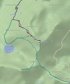 Silver Peak GPS Track 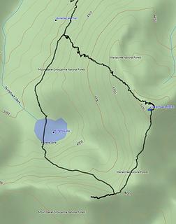 Silver Peak GPS Track B
|
| Back to top |
|
|
babylero
Member
Joined: 09 Oct 2020
Posts: 95 | TRs | Pics
Location: Tacoma |
|
babylero
Member
|
Tue Jan 19, 2021 7:50 pm |
|
|
I'm thinking of attempting Silver Peak from Lake Annette trail this weekend. I'm looking for advice as to where I should leave trail to attain the ridge, I've seen several elevations/areas mentioned:
Should I leave at top of the switchbacks near 3300 feet or further south, close to 3600 feet.
|
| Back to top |
|
|
Randito
Snarky Member

Joined: 27 Jul 2008
Posts: 9512 | TRs | Pics
Location: Bellevue at the moment. |
|
Randito
Snarky Member
|
Thu Jan 21, 2021 7:35 am |
|
|
IDK, but when I've skied from Silver Peak to Lake Annette, we leave the N ridge at about 5200 ft ski open slopes directly west to near the outlet of the lake.
The ridge above the 5200 level has an outcrop that can be bypassed to the west to reach the summit.
This is what those open slopes look like:
|
| Back to top |
|
|
babylero
Member
Joined: 09 Oct 2020
Posts: 95 | TRs | Pics
Location: Tacoma |
|
babylero
Member
|
Fri Jan 22, 2021 11:12 pm |
|
|
I've seen a few tracks descend that route, but most attain the ridge on ascent further north.
|
| Back to top |
|
|
Cascader
Boondocker

Joined: 09 Feb 2021
Posts: 7 | TRs | Pics
Location: Edmonds |
|
Cascader
Boondocker
|
Tue Feb 09, 2021 8:09 pm |
|
|
Has anyone done it yet this January? If so what are conditions.
|
| Back to top |
|
|
|
|


