| Previous :: Next Topic |
| Author |
Message |
kitya
Fortune Cookie


Joined: 15 Mar 2010
Posts: 842 | TRs | Pics
Location: Duvall, WA |
|
kitya
Fortune Cookie
|
 Sun Mar 15, 2020 11:51 pm |
|
|
Want to self isolate in King County? Cleveland Mountain is a great place for that. It is a scramble to that seems to be rarely done. Just like other $ creek area mountains I have scrambled before - Bing, Palmer and Lennox - Cleveland is mercilessly steep and brushy, perhaps even more than usual. I made a mistake of starting at the abandoned mine and scrambling directly up to Temple Mountain (for no good reason!). It was not pleasant and so crazy steep that in fact once I got cliffed out and had to down climb a lot and go search for another way. Standard route is a lot more reasonable (I went standard route on my way down and enjoyed it a lot more).
The summit of Cleveland is also very steep (though not as steep as the ridge to Temple) and should be avoided when avy danger is higher. It has some cornices and sun is already warming up the snow with more warming forecasted this week  (((
Summit views were amazing though - all three major volcanoes (Koma Kulshan, Dakobed and Tahoma), as well as in your face views of Lennox and other nearby peaks. (((
Summit views were amazing though - all three major volcanoes (Koma Kulshan, Dakobed and Tahoma), as well as in your face views of Lennox and other nearby peaks.
|
| Back to top |
  
|
|
timberghost
Member

Joined: 06 Dec 2011
Posts: 1328 | TRs | Pics
|
So essentially you trespassed on private property. That road is private and I know there are signs on it stating so
|
| Back to top |
|
|
kitya
Fortune Cookie
Joined: 15 Mar 2010
Posts: 842 | TRs | Pics
Location: Duvall, WA |
|
kitya
Fortune Cookie
|
Mon Mar 16, 2020 7:41 am |
|
|
| timberghost wrote: | | So essentially you trespassed on private property. That road is private and I know there are signs on it stating so |
Which road are you talking about? I have seen no signs on NF-6422 indicating it is private, nor heard any other people (except you) mentioning it. Though even if it was private, I wouldn't care about it less - private land ownership is stupid.
|
| Back to top |
|
|
MangyMarmot
Member

Joined: 06 Apr 2012
Posts: 474 | TRs | Pics
|
I've been up there before. I don't believe any of that land is private property. It's an old abandoned logging road.
|
| Back to top |
|
|
fourteen410
Member

Joined: 23 May 2008
Posts: 2628 | TRs | Pics
|
King County parcel records indicate that the land FS 6422 crosses belongs to George Wilson. Is there is an easement when a public road crosses private land? The answer is often murky. Personally, I believe all FS roads should be considered public, even when they cross private land.
SummitPost does list FS 6422 as the standard route, so perhaps there is misleading information out there that needs to be updated.
Kitya, I hope this doesn't discourage you from continuing to post trip reports. I find yours particularly helpful.
|
| Back to top |
|
|
Stefan
Member

Joined: 17 Dec 2001
Posts: 5091 | TRs | Pics
|
|
Stefan
Member
|
Mon Mar 16, 2020 11:33 am |
|
|
great pictures Kitya! Keep up those trip reports!
|
| Back to top |
|
|
Sculpin
Member

Joined: 23 Apr 2015
Posts: 1384 | TRs | Pics
|
|
Sculpin
Member
|
Mon Mar 16, 2020 12:09 pm |
|
|
| fourteen410 wrote: | | King County parcel records indicate that the land FS 6422 crosses belongs to George Wilson. Is there is an easement when a public road crosses private land? The answer is often murky. |
This one does not look that murky to me. Most public roads are ON private land, the road in front of my house is half mine. But the public has a 30 foot easement on my side, same goes on the other side. Unless timberghost can produce evidence, I would say this looks like legal public access to me, whether it be by basic right of public access in an easement, or by adverse action if it has been used regularly for a while.
Between every two pines is a doorway to the new world. - John Muir
Between every two pines is a doorway to the new world. - John Muir
|
| Back to top |
|
|
timberghost
Member
Joined: 06 Dec 2011
Posts: 1328 | TRs | Pics
|
I know George he was up there this past year when he posted those signs. There was people dumping trash and camping there and has since had the county sheriff watching it. He has people down at Money creek home owners checking reporting it.
|
| Back to top |
|
|
RichP
Member

Joined: 13 Jul 2006
Posts: 5634 | TRs | Pics
Location: here |
|
RichP
Member
|
Mon Mar 16, 2020 1:43 pm |
|
|
This peak may have to be approached from another area then. Too bad some rotten apples spoiled it for everyone. That route has been used for many years, mainly during the winter and spring when the brush is covered in snow.
My experience has been the same with landowners. They eventually get tired of the abuse and shut it down for everybody.
|
| Back to top |
|
|
Justus S.
Member
Joined: 17 Nov 2004
Posts: 1298 | TRs | Pics
Location: WA |
Cleveland is nice.  I unfortunately visited it in the clouds.
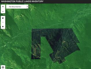
This is the private land parcel so would appear going up toward temple would avoid any private property if the owner chose to close off the land. I unfortunately visited it in the clouds.
This is the private land parcel so would appear going up toward temple would avoid any private property if the owner chose to close off the land.
 lands
|
| Back to top |
|
|
Sculpin
Member
Joined: 23 Apr 2015
Posts: 1384 | TRs | Pics
|
|
Sculpin
Member
|
Tue Mar 17, 2020 7:41 am |
|
|
| Justus S. wrote: | | This is the private land parcel so would appear going up toward temple would avoid any private property if the owner chose to close off the land. |
Good work Justus. If folks like us don't push for our rights, there are plenty who want to take them away.
Between every two pines is a doorway to the new world. - John Muir
Between every two pines is a doorway to the new world. - John Muir
|
| Back to top |
|
|
kitya
Fortune Cookie
Joined: 15 Mar 2010
Posts: 842 | TRs | Pics
Location: Duvall, WA |
|
kitya
Fortune Cookie
|
Tue Mar 17, 2020 9:10 am |
|
|
Thank you Justus S.! It appears from your map and comparing to my way up (on my map) toward Temple indeed didn't cross the private lot in question. Which explains why I have never seen any signs about private property - I only took the standard route (next to the logging road) down and since these signs were facing the other way I didn't even notice them.
| Justus S. wrote: | lands |
Unfortunately I should also add that direct route to Temple is a lot less nice than the route along the logging road. There is a lot more brush, big rock/cliff outcroppings above the old mine and it is noticeably steeper too. It is workable, but road is better.
Closing off forest that nobody even lives on and blocking access to ALW is not cool. It is just rent seeking. And land owners often trash their own land the most. It looks like owner also plans to do some logging - there was some tape on the trees I noticed indicating 'timber harvest'. Hikers on the other hand do care about LNT and cleanup - for example I removed a couple of dead mylar balloons from the forest on my way.
|
| Back to top |
|
|
timberghost
Member
Joined: 06 Dec 2011
Posts: 1328 | TRs | Pics
|
The signs are right on the first switch back before the old road that goes out to Kimball creek. So trying to go to the mines even is on Private
|
| Back to top |
|
|
kitya
Fortune Cookie
Joined: 15 Mar 2010
Posts: 842 | TRs | Pics
Location: Duvall, WA |
|
kitya
Fortune Cookie
|
Tue Mar 17, 2020 10:05 am |
|
|
| timberghost wrote: | | The signs are right on the first switch back before the old road that goes out to Kimball creek. So trying to go to the mines even is on Private |
NOPE. The mine (at least the mine I found) is at N47.71043 W121.41791. It is less 0.5 mile away from $ creek road intersection, way before first switchback on the road NF 6422 (which is 1.1 miles away from the same intersection). The mine I went to and my route up never ever came even close to the private property boundary shown on the parcel viewer. I never went anywhere close to the first switchback on my way up.
Perhaps there is more than one mine.
|
| Back to top |
|
|
Schroder
Member

Joined: 26 Oct 2007
Posts: 6720 | TRs | Pics
Location: on the beach |
|
Schroder
Member
|
Tue Mar 17, 2020 12:18 pm |
|
|
People put up no trespassing signs on public land all the time. That is FR-6422 and is not private.
|
| Back to top |
|
|
|
|


