Forum Index > Trip Reports > Star, Courtney, Buttermilk Ridge and Oval Peak June 7-8 2020
 Reply to topic
Previous :: Next Topic
Author Message
Bluebird
suffering optional


Joined: 22 Jan 2014
Posts: 199 | TRs | Pics
Location: United States
Bluebird
suffering optional
PostFri Jun 12, 2020 7:29 pm 
Nancy and I had the days set aside and the weather wasn't super cooperative for a climb so we opted for a 4 peak scramble extravaganza in an area with acceptable weather. We started hiking the E fork Buttermilk trail under sunny skies around 12:45pm on Sunday afternoon. Very soon we came to the first stream crossing. It's probably a rock hop most of the time, but those were all underwater so we continued to the second crossing option, a log that I opted to butt scoot, as per usual.
After the crossing, we ascended a bit into a lot of flowers.
The next couple miles through a recent burn had a number of annoying blowdowns to go under, over, around, or log gynmastics. I'd estimate it at around 50+ logs but it definitely slowed us down because none of them were simple step overs. (Note, I have spoken to an acquaintence who works for the NF and they are very likely to clear this trail, she stated that they cleared over 400 trees from this trail last year!) There are also some soggy sections and a few stream crossings that require a little creativity or a handy log just upstream.
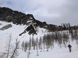
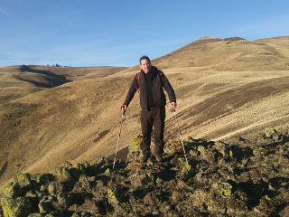
Around 5900 elevation the intermittent snow turned into significant snow cover. We continued approximately on the trail route, switchbacking up and then a long traverse to reach the pass between Courtney and Star peaks. The views of Star's dramatic cliffs were impressive.
We descended into the basin and found a snow-free patch under a tree to set up camp. Most of the basin is under significant snow. It was almost 6pm and we had a peak to bag, so we set off. The typical route goes around Star Lake, then uphill a bit and then traverses a scree slope to the ridge. The scree slope was partially melted out, but looked annoying so I picked a shorter steep route up snow and scree to the ridge, it worked.
ascending from the lake
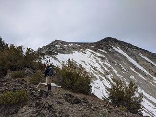
happily on the ridgeline
We traversed reasonably firm snow, some annoyingly postholey snow, scrambled rock and climbed around trees along the ridge. The final portion of the ridge is snow free to the summit.
It took us about 1 hour from camp to summit. We had a little cloud on the summit, and clouds moving around but got some peek a boo views.
We waited for a bit, but it was really cold in the wind so after about 10 minutes we headed back down and went to sleep. It snowed on our tent over the night and froze anything that wasn't in the tent. The 0f sleeping bag and 2 lb insulated pad (yeah, my gear is old!) that I hadn't *really* wanted to carry turned out to be perfect for the cold temperatures in the basin. Note: currently the only liquid water we found was at the outlet stream of Star Lake.
We started up towards Courtney around 7:45 the next morning, in less than an hour we were there. It was so windy and cold! There is a faint bootpath in places up the ridge, and sometimes it was probably covered in firm snow. We were able to boot up but it wasn't really easy to kick steps.
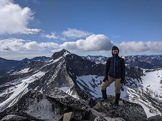
yes, it's cold enough for wearing my wind pants *under* my hiking pants, ha ha.
We were conflicted about taking the ridge from Courtney all the way to Oval. We had *heard* that the rock was really horrible and loose. So, we decided to drop to the saddle between Courtney and Buttermilk and drop packs. It took about 1 hour round trip to summit Buttermilk, which has some seriously large rocks, but they are mostly stable.
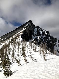
Courtney from Buttermilk
We dropped down some firm-ish snow to some liquid water. We traversed high about 7400 elevation here around Buttermilk, but it is probably easier to drop down a bit more than we did.
I opted for us to descending traverse in the route of most convenience towards the old trail to the lake beneath Oval Peak. At a talus field, I saw a cairn about 50 feet below us. So we dropped down and I followed the old trail, which is initially plagued with blowdown and difficult to follow, but later better. There are a few ancient blazes on the trees. We reached the lake below Oval, which is melted out but surrounded by snow.
I am not the best at blindly following GPS tracks, probably because I learned to navigate before GPS common. I roamed around the lake, then left-ish to join the ridge of Oval. We climbed some steep snow to the ridge and then scrambled mostly solid rock to the summit of Oval. It wasn't as bad as people say, and it looks like the ridge from Buttermilk to Oval would go, although the final drop to the Oval ridge looks steep and there was some pretty steep snow.
We decided to try the snow that was slightly off the ridgeline back. Although soft on top, it was firm beneath and I took a tumble that ended in semi-slow motion with my feet hitting some rocks. It probably would have been smart to have my axe out first! (I was also only wearing approach shoes for this trip which was a marginal but workable option for me). I took a slightly different route back that also worked fine. We then dropped directly down to the Butermilk trail via a 1,000 loss bushwhack. We had multiple GPS routes through here, each took a different route. I think if you just follow your map and stay in the lower angle terrain multiple routes will work here. Then we had about 4 miles of trail with the blowdown to travel through again. Reached the car around 7pm. Learned that the restaurants in Winthrop are all closed on Mondays?! (Not even takeout!) Total mileage was about 21 with approximately 10k vertical gain/loss with 3 bulgers and 1 top 200 peak. Great ladies night out biggrin.gif

zimmertr, reststep
Back to top Reply to topic Reply with quote Send private message
nurseventures
Member
Member


Joined: 12 Jun 2020
Posts: 1 | TRs | Pics
nurseventures
Member
PostFri Jun 12, 2020 9:00 pm 
Nicely written!

Back to top Reply to topic Reply with quote Send private message
cascadetraverser
Member
Member


Joined: 16 Sep 2007
Posts: 1407 | TRs | Pics
cascadetraverser
Member
PostTue Jun 16, 2020 7:25 am 
Cool area and nice TR; going up there this summer hopefully water will be a little easier to find!

Back to top Reply to topic Reply with quote Send private message
Brucester
Member
Member


Joined: 02 Jun 2013
Posts: 1102 | TRs | Pics
Location: Greenwood
Brucester
Member
PostWed Jun 17, 2020 12:04 pm 
Bluebird wrote:
Thanks for posting, great pics! So wide open and untouched! I love this area, thinking of possible "do overs" in the future! Wanna join, pm me smile.gif

Back to top Reply to topic Reply with quote Send private message
Bluebird
suffering optional


Joined: 22 Jan 2014
Posts: 199 | TRs | Pics
Location: United States
Bluebird
suffering optional
PostWed Jun 17, 2020 5:26 pm 
I appreciate the comments @cascadetraverser and @brucester! It's really nice terrain out there. I need to visit somewhere new in the general area in October for larches! (so far I have been to Hoodoo in April, the Gardners in September and now Oval et al in June)

Back to top Reply to topic Reply with quote Send private message
timberghost
Member
Member


Joined: 06 Dec 2011
Posts: 1324 | TRs | Pics
timberghost
Member
PostThu Jun 18, 2020 5:16 am 
Did you see any animals?

Back to top Reply to topic Reply with quote Send private message
Bluebird
suffering optional


Joined: 22 Jan 2014
Posts: 199 | TRs | Pics
Location: United States
Bluebird
suffering optional
PostTue Jun 30, 2020 11:32 am 
We saw no animals of significant size.

Back to top Reply to topic Reply with quote Send private message
Now I Fly
Member
Member


Joined: 07 Jun 2018
Posts: 465 | TRs | Pics
Now I Fly
Member
PostFri Jun 18, 2021 11:12 am 
Fun TR! Is there a chance you hiked in (or out) on the West Fork Buttermilk Trail? If so, might like to know that as of yesterday, a crew has cleared all of the blowdown to above where I cut off for Oval. Must have been at least fifty trees cleared! Made for a super sweet cruise out. :-)

Back to top Reply to topic Reply with quote Send private message
   All times are GMT - 8 Hours
 Reply to topic
Forum Index > Trip Reports > Star, Courtney, Buttermilk Ridge and Oval Peak June 7-8 2020
  Happy Birthday mtnwkr!
Jump to:   
Search this topic:

You cannot post new topics in this forum
You cannot reply to topics in this forum
You cannot edit your posts in this forum
You cannot delete your posts in this forum
You cannot vote in polls in this forum