| Previous :: Next Topic |
| Author |
Message |
Brucester
Member

Joined: 02 Jun 2013
Posts: 1102 | TRs | Pics
Location: Greenwood |
Lincoln Park Saturday was a nice urban escape...
Laid on the beach for awhile soaking up the sun and the sounds!
Wild clouds and tall trees, nice!
|
| Back to top |
  
|
|
Brucester
Member
Joined: 02 Jun 2013
Posts: 1102 | TRs | Pics
Location: Greenwood |
On Clark Mountain was the only sheep sighting I've ever had was from afar, some have all the luck!
How was the road?
|
| Back to top |
|
|
Downhill
Member

Joined: 30 Jul 2018
Posts: 342 | TRs | Pics
Location: Leavenworth |
|
Downhill
Member
|
 Tue Jun 16, 2020 5:00 pm |
|
|
Up the West Fork of the Foss River. Sunday, June 14, 2020.
Trout Lake @ 1.6 mi
Malachite Lake @ 4.0 mi
Copper Lake @ 4.2 mi
* Wonderful waterfalls near and far (we have had a lot of rain!).
* Easy hiking to Trout Lk with little elevation gain but lots of flora to enjoy
* Steep hike from Trout to the junction of Malachite and Copper trials. Trail is very well maintained with brush and logs removed (except the 40+ inches), a bit of mud here and there but much less than I'd expected west of the crest in early June.
* Snow encountered at about 3800-4000 as you top out of the switchbacks and head into the lake zone
* Malachite was 80% iced over and Copper was 95% ice
* Felt lucky to squeeze in a very scenic day hike between sucker holes of rainy weather.
Very pretty hike - one that I will return to when the snow has abated. Dogs are allowed here so that's a good thing or bad depending on your side of this topic.
|
| Back to top |
|
|
zephyr
aka friendly hiker

Joined: 21 Jun 2009
Posts: 3370 | TRs | Pics
Location: West Seattle |
|
zephyr
aka friendly hiker
|
Fri Jun 19, 2020 7:00 pm |
|
|
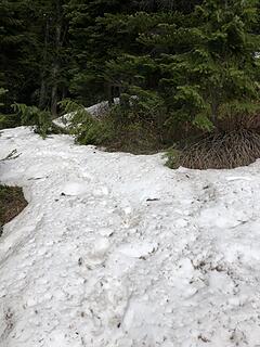
Ingalls Pass and Headlight Basin, Thursday, June 18. The North Fork of the Teanaway River road (FS 9737) was open and clear all the way to Esmeralda. Some potholes occasionally but in great shape compared to other years. Probably a couple dozen campers up and down the road in dispersed camping areas. Not many vehicles in the parking lot when I arrived around 9:15 am. The restroom was open, reasonably clean, stocked with t.p. The trail sign at the turn off to Long and Ingalls Pass was in its place. (It had been missing on my last visit in 2017.)
Plenty of creeks crossing the trail were running and water was abundant. Just a very few bugs, not really too annoying unless you lingered too long in certain spots. As I got higher I enjoyed the opening views to Mt. Rainier and distant Mt. Adams. Esmeralda and the surrounding peaks were spectacular. Fortune Peak looked immense from that angle.
Snow patches occasionally as you passed the turn off to Long Pass, then by 5800 feet elevation it began to show up in earnest. By 6000 feet or so the trail would be covered and initially you could see the trail by remnants of boot prints or sawn blowdown to indicate that there was trail below. But as you got closer to the Pass, the trail began to do a lot of switch backing under the cliffs and it became a maze. The snow was compact and several feet deep with a several inch layer of slush on top. It began to get slippery and putting on traction helped. Very near the Pass I was relieved to see the orange signs posted by the F. S. announcing the Wilderness area. It helped steer me through the cliffy portions at the end.
Folks with navigation devices shouldn't have too much problem. I had to get my map out and do some terrain association to choose which route on a couple of occasions. If you are someone who does this route several times a year or at least once a year, it's probably a non-issue. But I only get up there every few years--not enough to memorize the route through those rocks when in deep snow.
No one was at the top to greet me--no people, no goats. It was quiet with a light breeze. Very nice. Mt. Stuart was magnificient as were the peaks of Ingalls. I had half my lunch there on the dry rocks. I looked at a number of peaks I had scrambled with various partners over the years. Not Hinkhouse looked a little rugged from down below, but at one time I had come down from there with E.K. Lots of snow on Fortune, and covering the basin route up to South Ingalls. It had been sunny when I started yesterday morning, but clouds began drifting in during my ascent. This was fine with me because the bare sun was pretty warm.
Eventually I saw three distant figures on the trail around Headlight Basin. I waited for their arrival. Three folks who had overnighted at the Pass and been to Lake Ingalls for lunch. They hadn't seen anyone their entire trip. Eventually I headed up that way myself and took another lunch break on a nice big rock near the larches at Headlight B. Two other hikers came by on their way to the lake. They looked fresh and unencumbered--as if they had stepped out of an REI flyer.
I didn't go to the lake. I didn't have my axe and it was pretty slippery on those slopes. As I was heading down through the steep maze, the other two hikers showed up. They had a GAIA app on their phone. So we teamed up and navigated together through the cliffy portion. That was terrific and enjoyable to have the company. It was their first time in the Teanaways. I quickly suggested several other hikes for their future trips that offered similar view payoffs and levels of difficulty. Then they picked up the pace and I continued on.
I encountered two groups of two headed up. More vehicles were in the lot when I got back down. ~z
|
| Back to top |
|
|
neek
Member

Joined: 12 Sep 2011
Posts: 2338 | TRs | Pics
Location: Seattle, WA |
|
neek
Member
|
Fri Jun 19, 2020 7:13 pm |
|
|
^^ no pics?? OK then, here's a pano from Bean yesterday looking your direction (and others).
|
| Back to top |
|
|
zephyr
aka friendly hiker
Joined: 21 Jun 2009
Posts: 3370 | TRs | Pics
Location: West Seattle |
|
zephyr
aka friendly hiker
|
Fri Jun 19, 2020 10:42 pm |
|
|
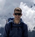
| neek wrote: | | here's a pano from Bean yesterday looking your direction |
Yes, that's me over there below Fortune Peak.  I loved those clouds yesterday. They gave dimension to the sky. And shielded me as well. Thanks! ~z I loved those clouds yesterday. They gave dimension to the sky. And shielded me as well. Thanks! ~z
|
| Back to top |
|
|
FiresideChats
Member
Joined: 20 Jan 2014
Posts: 365 | TRs | Pics
Location: San Juan Islands |
Had Lake Metam on the Mount Pugh Trail to myself on Friday night, which was a surprise. A nice spot for a solo hiker, but would be a tight squeeze for a larger party. Hit steady, obscuring snow at about 4700 under lowering skies on the way to the pass in the morning and headed back to other commitments. Lots of ripe salmon berries around the trailhead and the road up.
|
| Back to top |
|
|
OwenT
Member
Joined: 24 May 2014
Posts: 277 | TRs | Pics
Location: Moses Lake |
|
OwenT
Member
|
Tue Jun 23, 2020 4:09 pm |
|
|
Despite my concerns of it being a less than great trip, I don't think we could have asked for better conditions for our overnight backpacking trip last week (Jun 18-19).
We hiked from the Conrad Meadows TH starting around 2 pm and enjoyed the easy walk to Suprise Lake encountering virtually no snow. Another party that we saw coming the opposite directing near the TH had us worried because they said they were trying to make it to Suprise and had gone as far as they were comfortable going. Turns out they had taken the loop the opposite direction and encountered snow before the lake. Apparently, they weren't very prepared or adventurous. The lake was just melted out with 2 good campsites. The next day we finished the loop back down to Conrad Meadows. Starting at the Lake and until we got to the north side of the basin, the trail was completely snow-covered but my sisters made it across just fine in tennis shoes and we picked the trail back up. Great weather, few bugs.
|
| Back to top |
|
|
Nancyann
Member
Joined: 28 Jul 2013
Posts: 2319 | TRs | Pics
Location: Sultan Basin |
|
Nancyann
Member
|
Mon Jun 29, 2020 9:09 am |
|
|
We went up Poe via Little Wenatchee Ford on Friday. Trail was in good shape until 5,000 feet, then mostly route-finding in deep snow after that. I was glad to be wearing my Microspikes on the steep traverses. Awesome views all around of the snowy cascade crest, still a lot of melt out needed on the PCT for comfortable travel.
 Poe Mountain 6/26/20 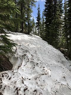 Poe Mountain 6/26/20 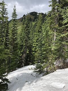 Poe Mountain 6/26/20  Poe Mountain 6/26/20 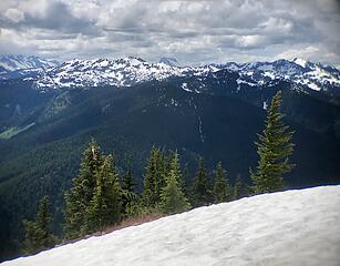 Poe Mountain 6/26/20 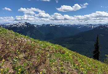 Poe Mountain 6/26/20 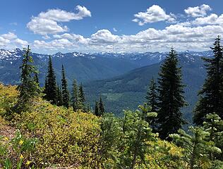 Poe Mountain 6/26/20 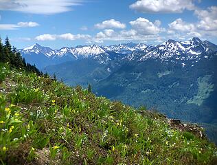 Poe Mountain 6/26/20 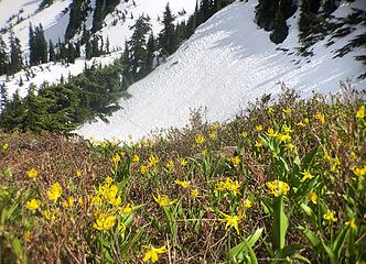 Poe Mountain 6/26/20 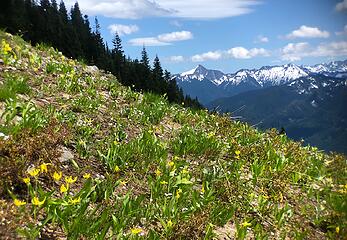 Poe Mountain 6/26/20 
 Poe Mountain 6/26/20 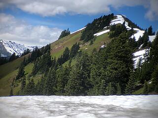 Poe Mountain 6/26/20 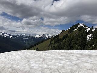 Poe Mountain 6/26/20 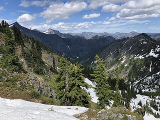 Poe Mountain 6/26/20 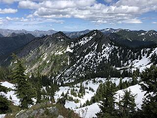 Poe Mountain 6/26/20 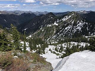 Poe Mountain 6/26/20 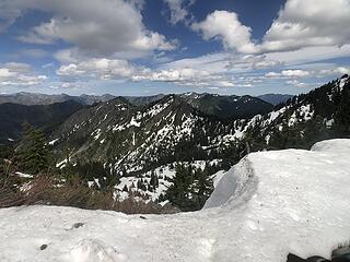 Poe Mountain 6/26/20
|
| Back to top |
|
|
Cyclopath
Faster than light

Joined: 20 Mar 2012
Posts: 7744 | TRs | Pics
Location: Seattle |
|
Cyclopath
Faster than light
|
Tue Jun 30, 2020 5:21 pm |
|
|
| neek wrote: | | ^^ no pics?? OK then, here's a pano from Bean yesterday looking your direction (and others).
|
|
| Back to top |
|
|
Brucester
Member
Joined: 02 Jun 2013
Posts: 1102 | TRs | Pics
Location: Greenwood |
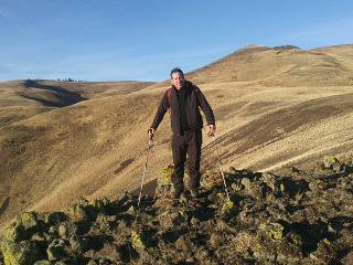
Nice day to do some rc 'wheeling up at the pass and beyond.
Was reflecting on hobbies that have little if any impact and others that have both environmental,visual and audible impacts on animals as well as people.
Not my mess but it is my responsibility to do the right thing...
|
| Back to top |
|
|
Brucester
Member
Joined: 02 Jun 2013
Posts: 1102 | TRs | Pics
Location: Greenwood |
Wow, I want some of that!!!
|
| Back to top |
|
|
kitya
Fortune Cookie

Joined: 15 Mar 2010
Posts: 842 | TRs | Pics
Location: Duvall, WA |
|
kitya
Fortune Cookie
|
Fri Jul 03, 2020 12:09 pm |
|
|
| Brucester wrote: | | Nice day to do some rc 'wheeling up at the pass and beyond. |
Wow! it looks really cool. Also thanks for cleanup!!!
|
| Back to top |
|
|
Cyclopath
Faster than light
Joined: 20 Mar 2012
Posts: 7744 | TRs | Pics
Location: Seattle |
|
Cyclopath
Faster than light
|
Fri Jul 03, 2020 10:20 pm |
|
|
| Brucester wrote: | | Wow, I want some of that!!! |
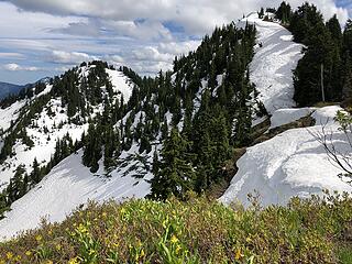
 Bean Peak in the Teanaway. Highly recommend. Trail follows a creek through a beautiful open forest to a really nice meadow with a rocky headwall. The trail goes up to the ridge where that was shot, and disappears. Fun little scramble to the peak. Few other peaks nearby too.
Looks like you had a fun day too! Where are you looking down on the lake from? (And thanks for taking in the trash!
Bean Peak in the Teanaway. Highly recommend. Trail follows a creek through a beautiful open forest to a really nice meadow with a rocky headwall. The trail goes up to the ridge where that was shot, and disappears. Fun little scramble to the peak. Few other peaks nearby too.
Looks like you had a fun day too! Where are you looking down on the lake from? (And thanks for taking in the trash!  ) )
|
| Back to top |
|
|
Malachai Constant
Member

Joined: 13 Jan 2002
Posts: 16093 | TRs | Pics
Location: Back Again Like A Bad Penny |
Nice quiet 20 mi MTB ride today no crowding mask at start and end .
"You do not laugh when you look at the mountains, or when you look at the sea." Lafcadio Hearn
"You do not laugh when you look at the mountains, or when you look at the sea." Lafcadio Hearn
|
| Back to top |
|
|
|
|


