| Previous :: Next Topic |
| Author |
Message |
Eaglecadd
Member


Joined: 05 Feb 2010
Posts: 185 | TRs | Pics
Location: Kailua Kona, HI |
Hi all, I'm going up West Foss Lakes and looping over to Necklace Lakes in 2 1/2 Weeks. I would sure appreciate any information you can pass on about snow and trail conditions. Also wondering if there are any campsites at Malachite Lake? How about climbing route to Malachite Peak?
Thanks for your help.
David
|
| Back to top |
  
|
|
SwitchbackFisher
Boot buster

Joined: 24 Feb 2018
Posts: 364 | TRs | Pics
Location: Wa |
It's a great loop, I have never hit malachite peak. I don't even remember if malachite had campsites I just took a peak as a short detour on my way up. Tons of information on this loop just use the search function.
I may not be the smartest, I may not be the strongest, but I don't want to be. I only want to be the best I can be.
I may not be the smartest, I may not be the strongest, but I don't want to be. I only want to be the best I can be.
|
| Back to top |
|
|
Waterman
Member

Joined: 21 Mar 2015
Posts: 589 | TRs | Pics
Location: Big Snow Quadrangle |
|
Waterman
Member
|
 Wed Jun 24, 2020 5:27 pm |
|
|
There's sites to the left as you get to the lake.
As for the high route it will be challenging with alot of snow
Two roads diverged in a wood, and I,I took the one less traveled by. And that has made all the difference.
Robert Frost
Two roads diverged in a wood, and I,I took the one less traveled by. And that has made all the difference.
Robert Frost
|
| Back to top |
|
|
Eaglecadd
Member
Joined: 05 Feb 2010
Posts: 185 | TRs | Pics
Location: Kailua Kona, HI |
Yeah, looks like plenty of snow this year. We will have to judge snow and safety considerations when we get there. We are researching a second route over to Opal lake area on the low side by the lakes if the high route is too difficult. May also go over to Mt. Hinman and Mt Daniel. Hoping to see the glacier.
Thanks All,
David
|
| Back to top |
|
|
puzzlr
Mid Fork Rocks

Joined: 13 Feb 2007
Posts: 7220 | TRs | Pics
Location: Stuck in the middle |
|
puzzlr
Mid Fork Rocks
|
Wed Jun 24, 2020 9:18 pm |
|
|
The final scramble/climb to the summit of Malachite is facing southwest. Because it's mostly rock I'd expect some of the area around the summit to be melted out by now. That's what I've been seeing on other peaks in the central cascades of about the same elevation. Snow conditions are have been really good lately. The basin and ramp on the west just before getting to the summit block will probably be a pretty steep snow traverse and there are cliffs below so no runout. If I had to decide, I'd say overall Malachite is do-able if you're comfortable on steep snow, and maybe better than late in the year when there's a lot of tedious talus.
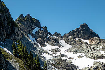 you'll be climbing/traversing that upper snow ramp with more snow than this July 21, 2019 shot. There's more snow this year.
|
| Back to top |
|
|
skiorkayak
Member
Joined: 09 Feb 2013
Posts: 49 | TRs | Pics
|
Yes, Malachite Lake has campsites. We installed a toilet there 6 years ago as part of an Eagle Scout project, hopefully that is still in decent shape too. Let me know if you get up there.
|
| Back to top |
|
|
Sky Hiker
Member
Joined: 03 Feb 2007
Posts: 1469 | TRs | Pics
Location: outside |
So you plan to take the high route this time of the year?
|
| Back to top |
|
|
Mike Collins
Member
Joined: 18 Dec 2001
Posts: 3094 | TRs | Pics
|
Do you really live in Hawaii? The link will take you to a trip report from my climb of Malachite twenty years ago. I did the climb in mid-July and definitely used an ice axe and recommend crampons for the high-angled snow. It is more complex than a walk-up. https://www.wta.org/go-hiking/trip-reports/tripreport-2000072208
|
| Back to top |
|
|
Eaglecadd
Member
Joined: 05 Feb 2010
Posts: 185 | TRs | Pics
Location: Kailua Kona, HI |
Hi All, Thanks for the input. Glad to know about the climb conditions, yes I do live in Hawaii now but born and raised in Puget Sound Region. We are planning to do the whole West Foss and cross over to Tank Lakes and down the Necklace trail. Hopefully get up into Hinman and maybe Daniels area, too. If The high route over to Opal Lake area is too iffy, we will go low by Otter Lake is then up to the higher lakes.
|
| Back to top |
|
|
Sky Hiker
Member
Joined: 03 Feb 2007
Posts: 1469 | TRs | Pics
Location: outside |
Hope you are prepared for snow
|
| Back to top |
|
|
Eaglecadd
Member
Joined: 05 Feb 2010
Posts: 185 | TRs | Pics
Location: Kailua Kona, HI |
Absolutely ready for snow. Ice axe and crampons at the ready.
|
| Back to top |
|
|
Alpineadam
Mr
Joined: 22 May 2017
Posts: 7 | TRs | Pics
Location: Spokane |
I did a loop: trout, delta, otter, azurite, azure, chetwoot, west foss lakes out. Should have taken an extra day to get over/under iron cap to tank lakes and view. Didnt need any snow or climbing gear. We all had pack rafts. I used a klymit that held 185 lb me and my 35 lb pack. I drilled holes in the tips of my hiking poles and bolted on just the plastic yellow paddles from a cheap inflatable setup. It worked great but we stayed pretty close to shore and wind could have pinned us to one side of the lake if it blew too hard. We ascended two rock slides out of otter and azurite. One part had us passing our packs up ledges. Laughably short distance days, it took us 3 days of hiking. No slide alder if you stay on track and have a boat. Its my little secret but hey youre coming all the way from Hawaii!
|
| Back to top |
|
|
Sky Hiker
Member
Joined: 03 Feb 2007
Posts: 1469 | TRs | Pics
Location: outside |
|
| Back to top |
|
|
pula58
Member
Joined: 13 Aug 2009
Posts: 588 | TRs | Pics
|
|
pula58
Member
|
Fri Jul 31, 2020 10:16 am |
|
|
I wouldn't want to do the high route with lots of snow on it. Especially the iron cap mountain section. I have done the high route before (West Foss lakes-> Iron Cap-> Tank lakes-> necklace valley), and no way would I personally do it with snow, but hey, that's just me my wife concurs).
|
| Back to top |
|
|
Malachai Constant
Member

Joined: 13 Jan 2002
Posts: 16092 | TRs | Pics
Location: Back Again Like A Bad Penny |
Did in snow for most of It actually easier to go around Chetwooth Lake in deep snow.
"You do not laugh when you look at the mountains, or when you look at the sea." Lafcadio Hearn
"You do not laugh when you look at the mountains, or when you look at the sea." Lafcadio Hearn
|
| Back to top |
|
|
|
|


