| Previous :: Next Topic |
| Author |
Message |
benneke
Member


Joined: 15 Sep 2018
Posts: 35 | TRs | Pics
|
|
benneke
Member
|
 Wed Aug 05, 2020 8:38 pm |
|
|
Recently got back from a Bailey Range traverse where we entered via Obstruction Point and exited Sol Duc. As far as I know it is an uncommon way to approach the Bailey Range so I wanted to write a trip report share with others who may be interested. This was my first time in the Bailey Range but I have hiked nearly every maintained trail in ONP. I believe that the route we did is one of the most direct ways to access the Bailey Range. While it includes a fair bit of extra off-trail travel, it is very scenic and there isn't a ton of extra elevation gain since you start so high up. I find the extra road walking to get to the Elwha very boring. The North Fork of the Quinault is by far the most direct way to get to the Baileys but it requires a long flat-ish trail I have done many times and a longer drive to shuttle cars.
Here is a rough map of our route: https://caltopo.com/m/3HQH
Day 0:
We wanted to start on Sunday 7/26, so we shuttled a car to Sol Duc and had my partner's dad who lives nearby drive us up to Obstruction. We were heading up to Hurricane Ridge around 11am when we got stuck in traffic.. the parking lot at the Ridge was full and they were only letting one car up for every car going down. Its a shame that they don't have any system to accommodate people heading to Obstruction Pt. We waited in line for nearly an hour until traffic stopped moving completely and we were told there was a major accident up the road and traffic would be stopped for several hours at least. Visiting national parks on summer weekends can be so frustrating. We turned around and decided to try again the next day
Day 1:
Made it up to Obstruction Pt this time, hiked out on the very scenic Lillian Ridge to "Low Pass" where we turned off to Lillian Lake. Never been to the lake before and the route gets a bit confusing at times. The lake is gorgeous, probably my new favorite spot in ONP that is easily reachable in a day. We continued above the lake to the ridge below McCartney Peak and traversed over to Cameron Pass. This section was a little harder than I expected, nothing like the northern Baileys but definitely some tiresome scree and side-hilling involved. We camped near Lost Pass where there was still a solid stream flowing.
Photos from Day 1: https://imgur.com/a/nNsrOYs
Day 2:
Hiked on-trail down to Dose Meadows, over Hayden Pass, down to the Elwha and camped at Chicago Camp. Not much to report other than how disappointing it is how much the NPS has disregarded the trail in the upper Elwha and let it get so rough and brushy. Hayden Pass trail is in excellent shape.
Day 3:
Hiked up the Elwha Snowfinger to Bear Pass, traversed the southern Baileys and camped in Ferry Basin. Getting from the end of the old "Elwha Basin" trail, through the brush and around the cliffs to the base of the snowfinger was one of the biggest navigational challenges of the trip. Not a ton of snow left in the snowfinger but we made it over the snowhump without issues. The southern Baileys have some of the best scenery I have ever witnessed, definitely the highlight of the trip. Nonstop jaw-dropping views from Dodwell-Rixon to Ferry Basin. We definitely needed the ice axes a couple times on some steep snow in this area.
Photos from Day 3 (I took a lot): https://imgur.com/a/tQ4HrwZ
Day 4:
Ferry Basin to the Catwalk. The first few miles north of Ferry Basin were the other main navigational challenge of the trip. This area is notorious for turning people around, we tried to stay as high as possible to avoid the notorious "Cream Lake Vortex" we had heard about but we still ended up bushwhacking and scrambling a bunch which got tiresome. Eventually we got back on the use trail below Steven Peak and the navigation was relatively straightforward after that. The gullies around Eleven Bull Basin are no joke. They were all clear of snow but the steep dirt and scree is exposed and scary. Major consequences for any wrong step. Honestly this section was way more dangerous than I had anticipated given the popularity of the route. We finished the day with the Catwalk which I felt wasn't bad compared to the gullies south of it and found a campsite just past it. We were so worn out from the gullies that we skipped Mt Carrie. While the scenery is stellar in the northern Baileys, I probably wont be back for a while because of how much work they are to travel thru and the danger in the gullies. Next time I will probably try to exit via Ludden and Dodger Pt to avoid the north Baileys.
Photos from Day 4: https://imgur.com/a/tQ4HrwZ
Day 5:
Hike out via Cat Basin and Sol Duc River
|
| Back to top |
  
|
|
RodF
Member

Joined: 01 Sep 2007
Posts: 2593 | TRs | Pics
Location: Sequim WA |
|
RodF
Member
|
Thu Aug 06, 2020 6:47 pm |
|
|
"of all the paths you take in life, make sure a few of them are dirt" - John Muir
"the wild is not the opposite of cultivated. It is the opposite of the captivated - Vandana Shiva
|
| Back to top |
|
|
cascadetraverser
Member

Joined: 16 Sep 2007
Posts: 1407 | TRs | Pics
|
You did all that in 5 days?? Wow.....
I did the Bailey`s from Boulder Lake to Blue Lake through the Bailey`s and out via the Skyline trail. We did it in 9 days but I am a mere mortal...
|
| Back to top |
|
|
meck
Member
Joined: 31 Dec 2010
Posts: 920 | TRs | Pics
|
|
meck
Member
|
Thu Aug 06, 2020 8:25 pm |
|
|
Excellent TR! I'm very envious of the views you got! Do you have any photos of the chutes & gullies? (I hated those things when I went through in 2014).
Please oh please don't post this TR "elsewhere on the web"...
*Just say NO to Rent-Seeking, don't give up the concept of "ownership"*
*Just say NO to Rent-Seeking, don't give up the concept of "ownership"*
|
| Back to top |
|
|
RAW-dad
Member

Joined: 07 Jul 2017
Posts: 119 | TRs | Pics
Location: Oregon |
|
RAW-dad
Member
|
Thu Aug 06, 2020 8:34 pm |
|
|
|
| Back to top |
|
|
benneke
Member
Joined: 15 Sep 2018
Posts: 35 | TRs | Pics
|
|
benneke
Member
|
Fri Aug 07, 2020 7:36 am |
|
|
Unfortunately I didn't take any photos of the gullies, at the time I was too preoccupied with trying to get through them alive to think about anything else, but in hindsight I definitely should have captured some
|
| Back to top |
|
|
coldrain108
Thundering Herd

Joined: 05 Aug 2010
Posts: 1858 | TRs | Pics
Location: somewhere over the rainbow |
2 years ago we ran into a couple who got turned back by those gullies. The guy took a fall and injured his shoulder I think. They were starting from the Sol Duc so they turned back. Later that trip we ran into another couple who started at Glacier Meadows, they said they had to drop way below one of the gullies to get through. Big difference running into that at the end instead of the beginning of that trek, no turning back - must find a way through.
Since I have no expectations of forgiveness, I don't do it in the first place. That loop hole needs to be closed to everyone.
Since I have no expectations of forgiveness, I don't do it in the first place. That loop hole needs to be closed to everyone.
|
| Back to top |
|
|
benneke
Member
Joined: 15 Sep 2018
Posts: 35 | TRs | Pics
|
|
benneke
Member
|
Fri Aug 07, 2020 10:44 am |
|
|
Had I known how nasty the gullies were I'm not sure if I would have planned the trip in this way where we were so committed. However, I felt like going northbound is probably the safer way to do it, as you are going uphill through the most exposed spots where I wouldn't want to be going downhill.
|
| Back to top |
|
|
Fatrick
Member

Joined: 09 Aug 2011
Posts: 27 | TRs | Pics
|
|
Fatrick
Member
|
Fri Aug 07, 2020 11:01 am |
|
|
Huge days! Two of the best routes in one go!
| Quote: | | While the scenery is stellar in the northern Baileys, I probably wont be back for a while because of how much work they are to travel thru and the danger in the gullies. Next time I will probably try to exit via Ludden and Dodger Pt to avoid the north Baileys. |
IMO Ludden exit is harder than Northern exit and dropping off of Ferry is worse than the gullies, but it's bad either way. Out Sol Duc is faster overall from Ferry Basin I think.
|
| Back to top |
|
|
benneke
Member
Joined: 15 Sep 2018
Posts: 35 | TRs | Pics
|
|
benneke
Member
|
Fri Aug 07, 2020 12:09 pm |
|
|
Just read your trip report on the Ludden exit.. looks like there aren't any easy ways in or out of the Baileys. I guess thats not a bad thing, keeps the range from getting overrun
|
| Back to top |
|
|
haydenslides
Member
Joined: 23 Feb 2009
Posts: 78 | TRs | Pics
|
Wow! Impressive trip! When I did the Crisler Traverse about 10 years ago I too found the gullies to be the sketchiest part of the whole trip. Beautiful photos, thank you for sharing.
|
| Back to top |
|
|
Fullripbrian
Member
Joined: 10 Jan 2018
Posts: 29 | TRs | Pics
|
In 2016, I went southbound and avoided the gullies by summiting Carrie then descending the Fairchild Glacier and crossing into Stephen Basin then circumnavigating Stephen Peak to the East from the unnamed lake SE of Stephen Lake. It was gnarly as hell but still better than the gullies.
No easy way for sure.
|
| Back to top |
|
|
RAW-dad
Member
Joined: 07 Jul 2017
Posts: 119 | TRs | Pics
Location: Oregon |
|
RAW-dad
Member
|
Sat Aug 08, 2020 12:09 pm |
|
|
| benneke wrote: | | Unfortunately I didn't take any photos of the gullies |
At the risk of stoking some nightmares, here are some gully pics from a 2017 BRT (Lake Crescent to Elwha SF). They don't look so bad here... suppose we never pause to take photos at the gnarly spots!
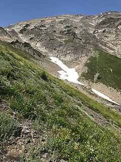 NWgully 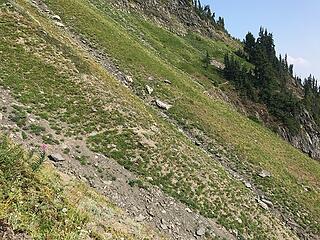 MIDgully 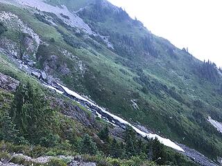 SEgully1 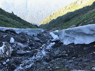 SEgully2
|
| Back to top |
|
|
|
|


