| Previous :: Next Topic |
| Author |
Message |
Pribbs
Member


Joined: 13 Aug 2010
Posts: 179 | TRs | Pics
Location: Sammamish, WA |
|
Pribbs
Member
|
 Wed Oct 07, 2020 1:46 pm |
|
|
GPS track Wing Lake to summit (perfect route!): https://www.gaiagps.com/public/JHcESa0cC5HkNayp1Yl63BMa
We arrived at the Rainy Pass trailhead at 12:30pm on a Monday, and it was completely full with cars parked on the highway. We drove through the lot anyways and got lucky with someone leaving. We made quick work up the crowded trail to Heather Pass, then hung a right onto the way trail to Lewis and Wing Lakes, leaving the crowds behind. We hiked through some pretty meadows and larches as we began to make the descent toward Lewis Lake. The trail is easy to follow but does cross some pretty large boulder fields. There are lots of cairns to follow though the cairns could be confusing since there are multiple routes through the boulder field marked by cairns. But they are all the same. Eventually the trail crosses a large creek then a bit more to Lewis Lake, which has a cloudy appearance due to the glacial sediments.
The trail wraps around the right side of the lake before climbing steeply up through tons of golden larches to Wing Lake. The trail passes a pretty giant wall of a terminal moraine of a former glacier, which is pretty cool to see.
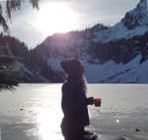
About 1000 feet above Lewis Lake, we reached Wing Lake at about 4:30pm. This lake is even more impressive, lined with larches and at the foot of Black Peak. There was only one other pair of folks who arrived before us to camp, so there were plenty of campsites to pick from.
What began as a pleasant evening became a pretty windy night with some pretty strong gusts regularly, so I got very little sleep. Still we woke up to witness the glorious sunrise colors lighting up Black Peak and we set out for the summit around 7:30am.
We began by first hiking up the first small hill that was before the rockfield behind it, then found the bootpath and steeply ascended the rocks of the glacial cirque up to the giant terminal moraine above. From here there were two options. One was to go straight up through the bowl, where we saw tracks crossing the snow patches. The other was to go right and up the moraine along the right side of the bowl. We saw an obvious boot path marked by a cairn, so we picked this option, which proved to be great.
But regardless with which option you take through the bowl, they both end up on a really steep, nasty, loose climb up dirt and scree to reach the saddle at 8000 feet. But the views from the ridge were amazing, looking across to Goode, Buckner, and Logan.
From here we followed the cairns and boot path up the south slope, and into the giant gully where we stayed toward the right side to scramble up some pretty nice class 2-3 rock, avoiding the loose stuff to the left. The gully soon splits in two and here be sure to take the right fork. At the top of the gully you will come to a large flat area just below the summit.
From here continue to follow the cairns ALL THE WAY to the far end of the summit ridge, avoiding the temptation to go up too soon up tempting looking places. At the far end as you wrap around to the other side, you will come to the obvious class 3 final short gully to the top, which does have maybe 1-2 low-class 4 moves.
We reached the summit around 10am to enjoy the spectacular views that featured numerous surrounding Bulger peaks like Goode, Storm King, Buckner, Boston, Logan, Snowfield, Baker, Shuksan, Picketts, Jack, Dome, Glacier, etc etc etc.
We didn't stay long before we retreated back to the flat area on the other side of the summit ridge where we took a longer break, and met another person on a day trip, before heading back down to the lake.
We returned to camp at 12:15 and took an hour to pack up and rest before an enjoyable hike out through the larches back to Heather Pass, where we got back on the "hiking freeway" back to the trailhead, getting back at 4:45.
|
| Back to top |
  
|
|
rbuzby
Attention Surplus
Joined: 24 Feb 2009
Posts: 1011 | TRs | Pics
|
|
rbuzby
Attention Surplus
|
Wed Oct 07, 2020 2:45 pm |
|
|
Sweet pics!
Good job finding the easy scramble route.
|
| Back to top |
|
|
Alden Ryno
Member

Joined: 04 Jun 2019
Posts: 150 | TRs | Pics
Location: Issaquah, WA |
Stunning shots!
Black and Silver Star are (deservedly) the introduction to many North Cascadian love affairs.
|
| Back to top |
|
|
KascadeFlat
Member
Joined: 06 Jul 2020
Posts: 316 | TRs | Pics
Location: Eating peanut M&Ms under my blue tarp |
For a good time call: 1-800-SLD-ALDR.
|
| Back to top |
|
|
Jesse_Frome
Member
Joined: 28 Sep 2020
Posts: 1 | TRs | Pics
Location: Kent |
Would you recommend an ice-axe if doing this one in late October?
|
| Back to top |
|
|
Pribbs
Member
Joined: 13 Aug 2010
Posts: 179 | TRs | Pics
Location: Sammamish, WA |
|
Pribbs
Member
|
Tue Oct 20, 2020 6:20 am |
|
|
| Jesse_Frome wrote: | | Would you recommend an ice-axe if doing this one in late October? |
There should be lots of new snow by then, so yes.
|
| Back to top |
|
|
OutOfOffice
Member

Joined: 02 Jun 2015
Posts: 91 | TRs | Pics
Location: Seattle |
| Pribbs wrote: | | Jesse_Frome wrote: | | Would you recommend an ice-axe if doing this one in late October? |
There should be lots of new snow by then, so yes. |
Can confirm. Just did the Maple Pass loop on Saturday and the area is covered in ~1-2ft of snow.
|
| Back to top |
|
|
|
|
You cannot post new topics in this forum
You cannot reply to topics in this forum
You cannot edit your posts in this forum
You cannot delete your posts in this forum
You cannot vote in polls in this forum
|
Disclosure: As an Amazon Associate NWHikers.net earns from qualifying purchases when you use our link(s). |


